
The latest news stories across the state of Oregon from the digital home of the Oregon coastal cities, OregonBeachMagazine.com
Wednesday, September 7, 2022
Oregon Beach Weather

Fire Weather Watch And Small Craft Advisories Issued By National Weather Service
...FIRE WEATHER WATCH REMAINS IN EFFECT FROM FRIDAY MORNING THROUGH SATURDAY MORNING FOR WIND AND LOW RELATIVE HUMIDITY FOR FIRE WEATHER ZONES 601, 612, AND 664...

* AFFECTED AREA...In Oregon, Fire Weather Zone 601 North Oregon Coast and Fire Weather Zone 612 Central Oregon Coast. In Washington, Fire Weather Zone 664 South Washington Coast and
West Willapa Hills.

* WINDS...Northeast 10 to 20 mph with gusts up to 40 mph.

* RELATIVE HUMIDITY...As low as 25 percent.

* IMPACTS...Conditions may be favorable for rapid fire spread which may threaten life and property. Use extra caution with potential ignition sources, especially in grassy areas.
Outdoor burning is not recommended.
SMALL CRAFT ADVISORY REMAINS IN EFFECT UNTIL 5 AM PDT FRIDAY... ...HAZARDOUS SEAS WARNING REMAINS IN EFFECT FROM 2 PM THIS AFTERNOON TO 5 AM PDT FRIDAY...

* WHAT...For the Hazardous Seas Warning, very steep and hazardous seas 8 to 12 ft, with seas dominated by short period wind waves. For the Small Craft Advisory, north winds 20 to 30
kt with gusts up to 35 kt and steep seas 8 to 10 ft, with seas dominated by short period wind waves.

* WHERE...For the Hazardous Seas Warning, all areas beyond 3 nm of the coast from Reedsport south, except closer in near the capes. For the Small Craft Advisory, all area not affected by the warning.

* WHEN...For the Hazardous Seas Warning, from 2 PM Wednesday to 5 AM PDT Friday. For the Small Craft Advisory, until 5 AM PDT Friday.

* IMPACTS...Very steep and hazardous seas could capsize or damage vessels. Bar crossings will become especially treacherous.

* View the hazard area in detail at https://go.usa.gov/x6hks

Seaside Shooting Fugitive Arrested In South Dakota
An Oregon man wanted for a shooting August 28th in Seaside was taken into custody following an arrest in South Dakota on Monday.

The City of Seaside said in a release Jeremy Morinville, 24, of Warrenton, was taken into custody by the Minnehaha County Sheriff’s Office in Sioux Falls, South Dakota around 7:20 p.m. Monday.
Police had been searching for Morinville since Aug. 28 when a Seaside man was shot at his home before driving himself to the hospital for treatment. The man’s injuries were considered non-life threatening.
Officials described the incident as not a random encounter but warned the public Morinville could be armed and dangerous.
Following his arrest Monday, Morinville was booked into the Minnehaha County jail and charged as a fugitive from justice.
Astoria Coast Guard Rescues Woman From Cruise Ship
An aircrew from U.S. Coast Guard Air Station Astoria evacuated a 66-year-old woman with medical issues from the Ruby Princess on Tuesday.
The cruise ship was about 75 miles southwest of the Columbia River Bar when the rescue took place, the Coast Guard said in a tweet.
The woman was taken to Oregon Health & Science University Hospital in Portland. Her condition was stable, the Coast Guard said


Light scattered showers were observed in Western Washington and Northwestern Oregon while the remainder of the
geographic area was dry. A warming and drying trend combined with increasing instability moved into the geographic region ahead of a trough.
These warmer and drier conditions allowed for increased activity and moderate growth on existing large fires while initial attack activity was light.
There were 18 lightning strikes served in the past 24 hours in Northeast Oregon and Southwest Oregon.
An upper-level trough will cross the region today, cooling temperatures in western Washington, while the rest of the region remains hot. The system will boost general winds, particularly through Cascade gaps and across the east side. Mid-level moisture and instability will support some potential for thunderstorms, mainly east of the Oregon Cascades.
Some of the storms over northeastern Oregon could get strong with gusty, erratic outflow winds. Little, if any, precipitation is expected to reach the ground. Temperatures will be cooler Thursday behind the system before rebounding Friday into the weekend.
A backdoor front will move down from British Columbia Friday, generating brisk northerly winds through the Okanogan Valley and other N-S oriented valleys and easterly winds across the Cascades to the coast. Models lack consistency at this point, but another trough possibly moves in from the Pacific late in the weekend or early next week pushing temperatures down closer to average and possibly bringing some chances for measurable precipitation and thunderstorms.
Significant fire potential remains elevated to high today due to the combination of high fire danger and hot, dry and
unstable weather. Increased winds and thunderstorm potential will lead to high risk for new significant fires for southern and eastern Oregon. Concerns then turn to the west side Friday into Saturday with easterly winds boosting spread potential for new and existing fires.
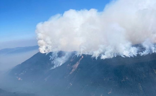
Double Creek.10 miles SE of Imnaha, OR. Start 8/30. Full Suppression. Cause: Lightning. 59,510 acres (+15,842). 0% containment. Timber. Extreme fire behavior. Evacuations in effect. Road, trail and area closures. These teams are also managing Nebo, Sturgill, Goat Mountain One and Goat Mountain Two incidents.
Cedar Creek Fire Evacuation Level Increases
Link to Map https://lcgisorg.maps.arcgis.com/apps/webappviewer/index.html?id=fffd5cd4131d40bc885331fe3c905283
15 Miles E of Oakridge, OR. Start 8/1. Full Suppression. Cause: Lightning. 18,143 acres (+518). 12% containment. Timber. Active fire behavior. Evacuations in effect. Road, trail and area closures.
Increased fire activity has prompted an increase in evacuation levels for areas around the Cedar Creek Fire. In addition to all previously issued evacuation notices remaining in effect, the Lane County Sheriff’s Office has issued the following evacuation level increases:
LEVEL 3 (GO NOW) EVACUATION NOTICES HAVE BEEN ISSUED FOR THE FOLLOWING AREAS
• McFarland lakes & Elk Creek Trail areas
Level 3 means leave immediately! Do NOT take time to gather things. GO NOW! There is immediate and imminent danger and you should evacuate immediately.
LEVEL 2 (BE SET) EVACUATION NOTICES HAVE BEEN ISSUED FOR THE FOLLOWING AREAS:
• Mink Lake Basin
Level 2 means: You must prepare to leave at a moment’s notice, and this may be the only notice that you receive.
The Deschutes County Sheriff’s Office has announced the following evacuation levels and corresponding areas:
LEVEL 3 (GO NOW) EVACUATION NOTICES HAVE BEEN ISSUED FOR THE FOLLOWING AREAS
Previous Level 2 evacuation areas including Johnny Lake, Clover Meadow, Lemish Lake, Many Lakes area, north to the line between Township 19 and 20 (approximately milepost 40.5 on Cascade Lakes Hwy). All areas west of the Cascade Lakes Hwy north of FS 4290 (Charlton Lake Road) north to Deschutes Bridge Area. This includes Cultus Lake, Little Cultus Lake, Corral Swamp, and the areas around Lemish and Ketchketch Buttes.
LEVEL 2 (BE SET) EVACUATION NOTICES HAVE BEEN ISSUED FOR THE FOLLOWING AREAS:Areas west of Cascade Lakes Hwy and south of FS 4290 (Charlton Lake Road) south to the line between Township 21 and 22 (approximately milepost 54 on Cascade Lakes Hwy). Areas between the Metolius – Windigo Trail / Six Lakes Trail and the County Line including Winopee Lake, Snowshoe Lakes and Leech lake.
LEVEL 1 (READY) EVACUATION NOTICES HAVE BEEN ISSUED FOR THE FOLLOWING AREAS:Areas around the west side of Crane Prairie from Deschutes Bridge south to FS 42 (South Century Drive including Browns Mountain, Cow Meadow, Quinn Meadow, and Rock Creek Campgrounds.
Public safety personnel cannot guarantee they will be able to notify you if conditions rapidly deteriorate. Continue to closely monitor your phone, local media and www.LaneCountyOR.gov/CedarCreek for information.
Rum Creek Fire. Cause: Lightning. 20,029 acres (+534). 42% containment. Timber. Active fire behavior.
Evacuations in effect. Road, trail and area closures. Transfer of command to NR Team 6 occurred yesterday at 1800.
The National Weather Service issued a Red Flag Warning today due to high temperatures and low relative humidity, which ended at 8 p.m. A Heat Advisory extends until 11 p.m. Wednesday, with more hot weather expected later in the week. As of 6 p.m., gusts were recorded up to 15 mph on the ridgetops in the fire, with stronger winds recorded nearby.
With high temperatures, low relative humidity, and some gusty winds, the Rum Creek Fire burned actively today. On the northwest part of the fire towards the Rogue River, firefighters found and suppressed a few small spot fires. The rest of the fire stayed within the containment lines.
The northwest corner near Montgomery Creek and the Rogue River has large unburned pockets of fuels, creating a potential for fire to flare up and make a push toward containment lines. To reduce the chance of this, fire personnel plan to do a tactical burn this evening. They will ignite an interior ridgeline, expecting the fire to walk down the slopes. By mid-day tomorrow, when fire activity increases, much of this area should be burned and cooling down.
Day and night shift firefighters are monitoring the fire, watching for flames to move into crowns of trees and spread embers. Ember showers pose a threat of igniting spot fires outside containment lines. Fire personnel cool flare-ups, using aerial resources if needed. They continue to conduct thorough mop up near structures and on the fire’s perimeter. In areas with scattered heat, increased fire activity helped crews locate residual heat. Some hidden hot spots begin to smoke, helping fire personnel locate and extinguish them.
Due to reduced threats to structures near the Rum Creek Fire, Oregon’s Office of State Fire Marshal Blue Team and remaining structural resources are completing their assignment here. On Wednesday they will be reassigned to other fires or return to their home units.
A weekend that started with a red flag alert could be a calm between two wind storms for Rum Creek Fire crews. Their 1,191 personnel today are fighting the wildfire’s 19,495 swath that has burned two homes and four other structures.
They’re progress toward containment of the deadly northern Josephine County wildfire stands at 34% today, up from 1% reported Thursday. Rum Creek Fire’s Unified Command (UC) reported steady progress through the weekend with slightly milder weather, which changes this week.
The National Weather Service had a Fire Weather Watch in effect for Tuesday afternoon and evening for the Rum Creek Fire area, forecasting hot temperatures, gusty winds and low humidity. It is widely expected to be re-issued again today (Wednesday). The Wild section of the Rogue River below Grave Creek will remain open unless fire conditions warrant closure. River status is determined on a day-to-day basis.
Oregon Power Companies Prepare To Cut Electricity To Prevent Wildfires Due To Weather
With winds picking up this week there could be cause for concern in mountain communities. Places that lost power just two years ago due to wildfire dangers are bracing for the possibility once more.
As of Tuesday, Sept. 6 no official shutdown has been announced. But both Pacific Power and PGE say it is possible, saying they’re monitoring the situation and if it’s needed, will spread the word soon.
Two wildfires burning near Weed, California are growing, one in acreage, the other in structure count.
CalFire says the Mountain Fire’s size is over 13 thousand acres this morning, with moderate fire behavior overnight and short periods of flare ups. A Red Flag Warning in effect yet again today for the area reflects hot and dry conditions conducive to wildfires.
It says crews have 20% containment of the Mountain Fire burning timber nine miles southwest of Gazelle near Gazelle-Callahan Road where 59 people have evacuated. It says the wildfire has destroyed two structures and two outbuildings while threatening 690 other structures.
The wildfire started Friday, and CalFire is asking for public help with information that could help determine its cause. The death count also stays at two from the Mill Fire, involving two women at separate locations within Weed city limits.
Senate Bill Would Fund Preventing Future Oregon Wildfires
Senate Bill 762 is an increased effort to prevent potentially deadly wildfires. However, the funds aren’t entirely directed at resources that help once a fire has already started.
Rather, a significant amount of the funds goes towards taking action before one begins.
Compliments of the $220 million grant, fire officials like Chad Hawkins are traveling the state and meeting with homeowners. They’re discussing how to make the area around their homes a defensible space that is safer from flames, because it “reduces the intensity,” Hawkins explained, and “allows folks to get out of their home, as well as allowing firefighters to get in there.”
Hawkins said anywhere between as few as eight or as many as 600 homeowners have attended community town hall meetings so far to talk about what that means.
The Bill and funds are aimed at helping to create fire-adapted communities and increase the resilience of Oregon landscapes. People like Hawkins are gleaning public input to put together the best plan of actions, so they “can really understand, or have a code that is built for Oregonians.”
A code Hawkins said will help prevent fires from moving from the ground, to igniting the tops of trees “where we see a lot of ember cast or ember shower.”
He added things like broken sticks and foliage are the ignition sources that embers go out searching for, and they’re usually hidden in places that you might now think about – like gutters.
What they take in from these meetings will likely be codified in December, but actual assessments on properties are still a ways away.
So far, they’ve held 13 out of the 17 meetings they’re planning to have.

Oregon Employment Department launches ‘Frances Online,’ new online portal for employers
The Oregon Employment Department’s new online portal, Frances Online, is now available to Oregon employers.
This marks the first rollout in a complex, multi-year effort to modernize the department’s business processes and core technology systems and make them more flexible, adaptable and efficient.
In this phase, Frances Online replaced the systems Oregon employers previously used to file their combined payroll reports. The portal also supports employers who want to submit equivalent plan applications for the new Paid Leave Oregon program.
“The launch of the Frances Online employer portal is the first step to simplify and streamline the unemployment insurance process and create a solid system of support for Paid Leave Oregon,” said David Gerstenfeld, acting director of the Oregon Employment Department. “Frances Online will provide improved, modernized services, such as online self-service and improved data collection, and it will help us integrate services, like payroll reporting, with partner agencies such as the Department of Revenue.”
Employers and third-party administrators can now do things in Frances Online like file and amend their payroll reports, find their tax rate and those of their clients, manage account access for themselves and their staff, view letters, and send and receive secure messages.
For Paid Leave Oregon, employers can use Frances Online to apply for an equivalent plan. An equivalent plan is when an employer provides paid leave benefits that are equal to or greater than those provided by Paid Leave Oregon. Employers with approved equivalent plans, and employees working for an employer offering an equivalent plan, do not have to pay contributions to Paid Leave Oregon.
The Employment Department’s Modernization Program is working to transform how the department does business, update the core technology systems supporting unemployment insurance, and create the technology to support the new Paid Leave Oregon program. The current, multi-year initiative is expected to be complete in 2024, supporting the functionality for Paid Leave Oregon contributions in January 2023, Paid Leave Oregon benefits in September 2023, and Unemployment Insurance benefits in March 2024.
You can learn more about Frances Online; find updated file specifications; and download how-to guides, infographics and informational videos by visiting francesinfo.oregon.gov and clicking on “Resources.”
Employers with questions about creating their account or filing their combined payroll report in Frances Online can call 503-947-1488 or email our team at ibutions.unit@employ.oregon.gov“>Contributions.unit@employ.oregon.gov.
### The Oregon Employment Department (OED) is an equal opportunity agency. Everyone has a right to use OED programs and services. OED provides free help. Some examples are sign language and spoken interpreters, written materials in other languages, braille, large print, audio and other formats. If you need help, please call 503-947-1444. You can also ask for help at Communications@employ.oregon.gov.
El Departamento de Empleo de Oregon (OED por sus siglas en inglés) es una agencia de igualdad de oportunidades. Todas las personas tienen derecho a utilizar los programas y servicios del OED. El OED proporciona ayuda gratuita. Algunos ejemplos son intérpretes de lenguaje de señas y lenguaje hablado, materiales escritos en otros idiomas, braille, letra grande, audio y otros formatos. Si necesita ayuda, llame al 503-947-1444. Los usuarios de TTY pueden llamar al 711. También puede solicitar ayuda en Communications@employ.oregon.gov.
Record Oregon Kicker Rebate Predicted
The potential income tax kicker rebate for 2023 in Oregon has grown by 500-million dollars over the forecast three months ago.
The Oregon Department of Revenue is forecasting a three-and-a-half billion dollar kicker which would be paid in 2024. The forecast depends on whether the Federal Reserve is successful in avoiding a recession.
Oregon’s kicker refund is triggered when tax revenue exceeds two-percent of the state’s budget. A mild recession could reduce revenue by one-point-two billion dollars.
Kickers are also calculated on business revenue. The forecast predicts the corporate tax kicker would total $1.1 billion in 2024, up from this spring’s forecast of $931 million. Businesses don’t get that money back, however. The corporate kicker is kept by the government and used for educational spending.
But at some point during the next couple of years, Oregon’s economy will sag as consumer spending and employment growth sour, the forecast warned. Just when and how severe that downturn would be remains a matter of debate, the forecast said.
Rising inflation can drive a recession. Forecasters said if inflation persists, Oregon could experience a recession by the third quarter of 2023, prompting job losses, income stagnation and weakened consumer spending and corporate profits.
If that happens, it will have a big impact on the state, the forecast said.“The potential recession would weigh heavily on (state) revenues over the next several years,” the forecast said.
But Oregon also could experience a soft economic landing, the forecast said. For now, government revenues remain flush.
A newly released population study shows Oregon now has more deaths than births.
State economist Josh Lehner said, in the last century the replacement rate has been tracked in Oregon, this is the first time we are seeing this trend. Both experts say it’s an alarming milestone but not a surprising one since Oregon’s birthrate has been declining for years and baby boomers are aging.
“We did expect that the death counts would start to overtake births, but we expected that maybe in 2025,” Sharygin said.
Lehner said the pandemic was a wildcard that sped up this trend, with virus-related deaths, but pointed out that so-called “deaths of despair” have also shown an upward trend nationwide and in Oregon.
“Unfortunately, in the last couple of decades we have also seen the deaths increase at a little bit faster rate than the demographics alone would suggest,” he said. “A lot of that has to do with some really dark and unfortunate trends with the opioid crisis and drug overdoses and suicides and things like that where the number of deaths are rising.”
With inflation and the potential for an economic recession, these experts say the birthrate is not likely to increase anytime soon. They say over time the low birth rate will likely exacerbate labor shortages.
“The labor market is tight; it will continue to be tight in the decade ahead, and to the extent that this birthrate remains really low, then it means demographically the labor market will be tight in 20 years,” Lehner said.
Sharygin says emerging research✎ EditSign✎ EditSign suggests countries that improve overall income equity and increase access to education seen their low birthrates pick back up.
“The hypothesis there is that when you give people conditions where they can expect a stable future and be kind of optimistic about the conditions that they will face, they are more likely then to have children,” he said.
With the Brookings Institute reporting the cost of raising a child spiking by 9% in recent years, lawmakers will face serious challenges in creating that sense of stability.

We want to keep you informed about COVID-19 in Oregon. Data are provisional and change frequently. Note: This report covers the four-day period from September 2 to September 5, 2022.For more information, including COVID-19 data by county, visit our dashboard: http://ow.ly/EL9x50KymTM

A new forecast from Oregon Health and Science University says another wave of coronavirus cases could hit Oregon by the end of next month. Cases and hospitalizations are projected to fall this month before spiking by the end of October due to waning immunity from current vaccinations. Cases are down throughout the state, with OHSU reporting a more than 40 percent drop in hospitalizations from its peak in July.


This is just a small compilation of missing women and their pictures in the area. There are of course women missing all over Oregon and men and children missing too. We don’t mean to dismiss that, however, there is an inordinate amount of women who go missing each week and there could possibly be a connection with an anomaly or two here and there. Sadly most of them never get any attention. Family and friends must keep any information going and lead investigations so that they aren’t just forgotten.


https://www.facebook.com/pg/Have-You-Seen-Me-Southern-Oregons-Missing-People-161249961222839/posts/
