

The latest news stories across the state of Oregon from the digital home of the Oregon coastal cities, OregonBeachMagazine.com
Monday, July 27, 2026
Oregon Beach Weather



Here’s the overview of our weather outlook, but be sure to check out what we’re predicting in your area: https://www.farmersalmanac.com/extended-forecast

Heceta Head Lighthouse Shines Again Now That Repairs Completed
After nearly five months of darkness due to mechanical repairs, the Heceta Head Lighthouse south of Yachats is again shining its light

The light in the Heceta Head lighthouse was turned on again Thursday, July 23, after repairs to gears that rotate its 10-foot-tall lens.
Specialists from Welch’s Machine Works in Eugene finished work last week on the huge carriage wheels that allow the lighthouse’s 10-foot-tall lens to rotate, according to media reports.
The old wheels, which lasted 13 years, were replaced with bronze versions. Repairs also included resurfacing the metal base upon which the wheels traveled.
The lighthouse’s lighting mechanism—known as a first-order Fresnel lens, designed by a French physicist and ordered in 1893 from a British company—was first lit on March 30, 1894, The Lincoln Chronicle reports.
The light, housed atop the 56-foot-tall lighthouse tower, shines a beam so powerful it can be seen 21 nautical miles out to sea. Heceta Head Lighthouse sits 206 feet above the Pacific Ocean just off Highway 101.
“The iconic 56-foot tower, and stunning setting, make it one of the most photographed on the Oregon Coast. The light atop the tower was first illuminated in 1894. Its automated beacon, seen 21 miles from land, is rated as the strongest light on the Oregon Coast,” the Oregon Parks and Recreation Department states on its website.
The upper floors of the light house are closed to the public, but the public can visit the first floor of the lighthouse from 11 a.m. – 3 p.m. in the summer (March through October) and 11 a.m. – 2 p.m. in the winter (November through February), weather and staff permitting.
Newport Symposium Will Bring Researchers Together to Discuss West Coast’s Gray Whales
Range-wide Gray Whale Science Symposium Coordinated by the Marine Mammal Commission and hosted by the Marine Mammal Institute at Oregon State University — Hatfield Marine Science Center, Newport, Oregon — September 9-10, 2026

Experts from every part of the whales’ historic range, from Mexico to the Arctic, will discuss recent trends in health, feeding behavior, distribution and population dynamics. They will also try to identify priorities for future research, monitoring and coordination among both public and private groups studying gray whale health.
A public range-wide Gray Whale Science Symposium will take place on September 9–10, 2026, coordinated by the Marine Mammal Commission and hosted by the Marine Mammal Institute at Oregon State University in Newport, Oregon.
This two-day scientific meeting will focus on gray whale ecology and health across the Eastern North Pacific (ENP) and Arctic and will synthesize current research and observations to improve understanding of recent trends in health, feeding behavior, distribution, and population dynamics, and to identify priorities for future research, monitoring, and coordination.
The Symposium goals are to:
1) Review gray whale ecology and health status in the context of recent marine ecosystem variability in the ENP and Arctic;
2) Outline future priorities for gray whale ecology research and health surveillance and monitoring to help fill identified data gaps and address management objectives;
3) Enhance communication amongst scientists from Mexico, USA and Canada monitoring and conducting research on gray whale population status, health and ecology; and
4) Produce a workshop report summarizing presentations and recommendations for future directions.
Meeting Format
Day 1: Presentations and poster session
Invited oral presentations will provide a range-wide overview of gray whale status, trends, feeding ecology and health followed by an evening poster session highlighting additional research and observations. Day 1 oral presentations will be available both in person and remotely.
Day 2: Facilitated discussions and synthesis
Structured discussions will focus on key themes, knowledge gaps, and future priorities, with the goal of identifying areas for coordination and next steps.
Note: The Day 1 evening poster session and Day 2 discussions are in-person only.
Registration Register here! Registration is open to all interested participants. Note: IN-PERSON REGISTRATION IS FULL but you can still register to attend virtually or join the waitlist to attend in-person. https://www.mmc.gov/events-meetings-and-workshops/other-events/gray-whale-science-symposium/
Coos County Sheriff’s Office introduces new online Concealed Handgun License (CHL)application, appointment scheduling and payment program

– The Coos County Sheriff’s Office (CCSO) is launching a new program in their Concealed Handgun Licensing (CHL) Department called “Permitium”. Permitium allows citizensto make appointments, apply for new or renewal CHL licenses, monitor application status, upload required documentation and pay for CHLs online. Permitium also allows citizens to schedule and pay for fingerprinting services not related to Concealed Handgun Licenses online.
This new system will shorten and simplify the appointment process which will also allow CCSO staff to see more applicants each day. Additionally, it will allow CCSO staff the ability to get an earlier start on the comprehensive background check process, resulting in shorter wait times for applicants to receive their license.
“We are in the habit of researching new ways to serve the public, especially if they can help streamline efficiencies. Applicants will still be able to walk in during the week, but giving them the ability toschedule their own appointments, pay before they get here and have an electronic option in additionto the paper is a win-win.” said Sheriff Fabrizio
Residents who are unable to make appointments online or use a credit/debit card can come down to the CHL Department Tuesday – Friday 8:30am-11:00am and 1:00pm-4:00pm to: apply for or renew their CHL license, pay for the appointment, and schedule CHL or fingerprinting appointments.

Lincoln County Grand Jury Unanimously Finds Law Enforcement Officers Justified in Their Use of Deadly Physical Force
On July 21, 2026, a Lincoln County Grand Jury unanimously found that Oregon State Police Lieutenant Joey Pollard and Newport Police Officer Jerimiah Mangum were each justified in their use of deadly physical force against Daniel Noonan, 50, on June 17, 2026.
The Grand Jury convened yesterday to hear testimony, review body worn camera, and examine scene diagrams. The following is a factual summary of the investigation:
On June 11, 2026, Lt. Pollard, Oregon State Police, received reports of a disturbance that had occurred at a fruit stand at the intersection of Highway 229 and Highway 101, Lincoln City, Oregon.
Evidence suggested that a male suspect had initially approached the fruit stand, yelled at a Hispanic female operating the stand, before destroying the fruit stand and leaving on an e-bike. The same male suspect then returned shortly after and proceeded to make racially motivated derogatory comments. At one point in the altercation, the male suspect was seen on video strangling a Hispanic male on scene. The male suspect could also be seen carrying a handgun on his right hip during the altercation.
Through a series of investigative means, Lt. Pollard identified the male suspect as Noonan, who was believed to be living in a residence off the Siletz Highway. On June 17, 2026, the Oregon State Police, accompanied by Officer Mangum of the Newport Police Department, responded to Noonan’s residence to arrest Noonan for the crimes of menacing, criminal mischief, assault in the fourth degree, strangulation, and bias crime in the first and second degree. Law enforcement arrived at the property at approximately 3:50 PM. While standing at the top of the path, Lt. Pollard observed Noonan, wearing full camouflage, walking up the path towards Lt. Pollard. It was apparent Noonan had drastically altered his appearance since the fruit stand incident by shaving his head and large beard.
Lt. Pollard asked Noonan if he was Danny. Noonan responded in the affirmative before raising a firearm and opening fire on Lt. Pollard, as well as four other law enforcement officers in Lt. Pollard’s proximity. Lt. Pollard returned fire and Noonan quickly retreated down the path towards his residence. Shortly after, Noonan reappeared again on the path and law enforcement instructed Noonan to show his hands. Noonan responded, “Fuck you, fuck you, you N lovers” before Noonan fired again. Lt. Pollard and Officer Mangum returned fire but lost view of Noonan.
Lt. Pollard, Officer Mangum, and other members of the Oregon State Police proceeded down the path and located Noonan lying on his back. Noonan had a handgun in his right hand and held the gun to his chest. Noonan was also holding a second handgun in his left hand. Noonan did not respond to commands to drop either weapon but was still breathing. Law enforcement observed what appeared to be a gunshot wound to Noonan’s head and later located a gunshot wound to Noonan’s lower abdomen.
Additional law enforcement responded to the scene and rendered medical aid to Noonan. Noonan was transported to the Samaritan North Lincoln Hospital but was pronounced deceased upon arrival.
The Lincoln County Major Crime Team (MCT) was activated and conducted an investigation into the use of deadly force. Lincoln City Police Department Detective Bud Lane led the investigation. Detectives from the Lincoln County Sheriff’s Office, Lincoln City Police Department, Newport Police Department, Toledo Police Department, Lincoln County District Attorney’s Office, and Oregon State Police Crime Lab participated in the investigation.
Pursuant to SB 111 protocol, Lt. Pollard and Officer Mangum were both placed on administrative leave pending the investigation. Lt. Pollard has approximately 29 years of police experience, including 26 years as a member of Oregon State Police SWAT. Officer Mangum has approximately 5 years of police experience and is a current member of the Lincoln County Tactical Response Team.
Noonan appeared to live alone. A search of Noonan’s residence revealed Noonan was in possession of a police scanner, additional firearms and ammunition, child pornography (child sexual abuse material), a small make-shift sex doll, as well as children’s underwear.
An autopsy was conducted by State Medical Examiner Dr. Henry McNett on June 18, 2026. Dr. McNett determined Noonan manner of death was a gunshot wound to the head. However, Dr. McNett noted a dark discoloration consistent with soot located at the entrance of the wound, consistent with a “contact” shot. This could be indicative of a self-inflicted wound. Noonan also sustained a gunshot wound to his lower left abdomen. Noonan had no prior criminal convictions.
The Grand Jury applied the facts of this case to the legal principles dictating circumstances when deadly physical force can be used. Specifically, the Grand Jury found that, under the totality of the
circumstances known to each peace officer, each officer reasonably determined that the use of deadly physical force was necessary as:
- Deadly physical force was necessary to defend a peace officer and/or another person from the use of threatened imminent use of deadly physical force;
- Under the totality of the circumstances existing at the time and place, the use of such force was justified.
The Grand Jury further found that no reasonable alternatives, such as verbal de-escalation, waiting or using other available techniques or resources were reasonable, safe or feasible to either officer at the time they used deadly physical force.
Under Oregon law, a District Attorney or Grand Jury, made up of Lincoln County residents, may make the final decision as to whether or not law enforcement officers were justified in their use of deadly force. This case was presented to the Grand Jury by District Attorney Jenna Wallace. The Grand Jury’s decision required reviewing relevant facts and evidence available and applying them to the legal principles above. The Grand Jury concluded unanimously that the actions of Oregon State Police Lt. Pollard and Newport Police Officer Mangum on June 17, 2026 was justified and lawful.
Most of the seats on the Seaside City Council will be up for election this November. All except one.
City leaders had hoped to appoint someone to the vacant Ward 3 seat this summer in time to also get that seat on the ballot in November. Whoever was appointed would serve through the end of this year. But no one applied,
Now the city’s is taking applications for the appointment until the seat is filled. Whoever is appointed will now serve out the rest of this year and through the next two years.
The Ward 3 seat became vacant following a successful recall election of former city councilor Seamus McVey.
Any applicant for the seat must have been a full-time resident of Seaside for at least the previous 12 months. They must be a current resident of Ward 3 and a registered voter. They also need to obtain 20 signatures from registered voters in the ward and complete an online application.
Six of the seven seats on the Seaside City Council will be on the ballot in November, including the position of mayor.
As of July 22, only incumbent Mayor Steve Wright, who is pursuing a second term, had met the filing requirements to be a candidate.
Incumbents have until August 18 to file. All other candidates have until August 25.
Former West Coast Game Park Safari Owner Sentencing Delayed to September

Sentencing was all set to get underway Monday afternoon in Coos County for the owner of West Coast Game Park Safari near Bandon.
In April, Brian Tenney pleaded guilty to dozens of felony charges, most involving animal neglect. In May 2025 law enforcement confiscated hundreds of animals from the park after investigators said many had been neglected and left starving.
The judge on Monday said there is an issue concerning restitution, as Tenney is currently involved in the sale of property to generate funds. The judge said he is bumping sentencing to give time for Tenney to resolve property matters in Nevada. Sentencing is scheduled to resume on Tuesday, Sept. 8 at 3 p.m.
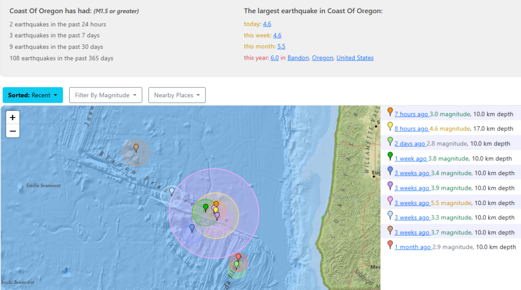
Active Earthquake Activity Along the Oregon Coast This Past Week
Back-to-back Earthquakes occurred off the Oregon coast Tuesday! A Magnitude 4.6 followed by a 3.0. That’s four in the last week.
Cape Perpetua Collaborative ·We’ve got some fabulous events over the next couple of weeks that you won’t want to miss

 !We kick things off on July 21st, with Riley Bellows Young Wavemaker Webinar presentation online, followed on July 31st in Portland for a multi documentary screening (one is about CPC!) at OMSI’s Empirical Theater!On Aug 2nd, swim by @oregoncoastaquarium for all things ROCKFISH
  don’t miss the Cape Perpetua Collaborative table for coveted BOFFFF stickers
  Aug 7-9th is the Annual Nesika Illahee Pow-Wow in Siletz! Get your dance sponsorships in before the big weekend
  Last but certainly not least, our friends at @foxflower.farm are hosting String and Shadow Puppet Theater on Aug 9th at the Yachats Commons
  Enjoy a beer in the beer garden at Pelican Brewery’s new Yachats location before the show- proceeds are donated to The Cape Perpetua Collaborative
The Siletz Bay Music Festival Preparing for its 11-day Run across Lincoln City and Newport

Eleven days. Twelve concerts. Venues fill up quick so be sure to reserve your seats early!
Get tickets here: https://app.arts-people.com/index.php?ticketing=sbmf
Lincoln County Sheriff’s Office Awarded High-Water Rescue Vehicle through Oregon SPIRE Grant
The Lincoln County Sheriff’s Office has been awarded a new high‑water rescue vehicle funded through the Oregon State Preparedness Infrastructure Resource Equipment (SPIRE) grant program. This specialized vehicle enhances emergency responders’ ability to respond to flooding, severe weather, and other emergencies.

Designed for challenging environments, this vehicle can safely access areas impacted by high water or debris. It is equipped with a custom 17-foot aluminum rescue body, integrated stairs, and a deep-water fording kit capable of navigating up to 50 inches of water. “This vehicle significantly expands our ability to reach community members during floods, storms, and other emergencies.” said Lincoln County Sheriff Adam Shanks.
In addition to navigating challenging environments, this vehicle is equipped with a lift gate for moving medical equipment, evacuees, and supplies. The interior accommodates approximately 25 passengers, including versatile fold‑down seating and wheelchair accessibility, providing critical capacity during evacuation operations.
The Oregon SPIRE program supports local jurisdictions by providing essential response equipment to improve resilience and collaborative emergency response capabilities statewide. “Our communities have unique needs and challenges before, during, and after disasters. This funding helps increase capacity for first responders throughout Lincoln County, not only the Sheriff’s Office.” Sheriff Shanks continued. The addition of this high-water rescue vehicle will enhance coordination with local fire departments, emergency management agencies, and regional partners during disaster operations. Although this grant was originally applied for and awarded in 2022, it was delayed due to supply-chain disruptions following COVID-19.
Nearly 50 years after the bodies of two teens from Alaska were found on the Oregon coast, authorities are still seeking answers into the unsolved case.

In 1978, Teresa M. Krause and Elena Jacobs were reported missing by the Tongue Point Job Corps center in Astoria.
Later that year, their bodies were found in the area of Del Rey Beach near Gearhart. Alisha Holland and Josh McCulloug, co-hosts of the Murder in the Rain podcast, joined us on AM Extra’s True Crime Tuesday to look back at the unsolved double homicide. https://www.murderintherain.com

Southern Oregon Dwarf Cars Saturday August 1 in Coos Bay
The Southern Oregon Dwarf Cars make their final appearance of the 2026 season at Coos Bay Speedway on Saturday, August 1, joining the NASCAR Local Racing Series presented by O’Reilly Auto Parts for an exciting night of racing on the NASCAR Dirt Oval.

These lightning-fast, high-horsepower machines have become a fan favorite thanks to their close, wheel-to-wheel competition and nonstop action. If you haven’t had the chance to see them this season, or want one last opportunity before they return in 2027, this is the night to be at Coos Bay Speedway.
The NASCAR Local Racing Series presented by O’Reilly Auto Parts will also be in action as drivers continue their battle for valuable championship points. With the season winding down, every position on the track becomes more important, setting the stage for an intense night of racing from green flag to checkered flag.
Gates open at 4:00 p.m., with racing beginning at 6:00 p.m. Come hungry and enjoy great food from the speedway concessions while cooling off with an ice-cold beverage from the on site 7 Devils Brew House as you take in one of the best nights of dirt track racing on the Oregon Coast.
Make plans now to join us on Saturday, August 1, for the final Southern Oregon Dwarf Car appearance of 2026 and another exciting night of NASCAR Local Racing Series action at Coos Bay Speedway.

One weekend- countless great flavors to try! Don’t miss the Annual Food Truck Off at @kokwelcasinoresort Coos Bay on Oregon’s Adventure Coast August 7-9, 2026!

This three-day event will feature up to 20 food trucks from the Pacific Northwest. Bring the whole family for a weekend of fun and vote for your favorite truck for the People’s Choice Award!
Coming in from out of town? Take advantage of our $75 Fuel Freebie promotion and get a $75 Gift Card to help cover the cost of gas! Visit oregonsadventurecoast.com/events to learn more about this and other events happening this summer on Oregon’s Adventure Coast: Coos Bay, North Bend, Charleston!
Florence Chamber to Host Ambassador Conference
The Florence Area Chamber of Commerce will host the 2026 Oregon State Chamber Ambassador Conference October 1st through 3rd at Three Rivers Casino Resort. The annual event will bring Chamber Ambassador volunteers from communities across Oregon to Florence for leadership training, professional development, and networking. Chamber President and CEO Bettina Hannigan says the conference is an opportunity to showcase Florence as a destination for meetings and conventions while generating business for local hotels, restaurants, shops, and attractions. Organizers expect hundreds of attendees from throughout the state.

Reedsport Fire Department Seeks Volunteer Ham Radio Operators
The Reedsport Volunteer Fire Department is looking for volunteers interested in becoming licensed ham radio operators to support emergency communications in western Douglas County. Training is online and offered at no charge.
The Reedsport Volunteer Fire Department is looking for volunteers interested in becoming licensed ham radio operators to support emergency communications in western Douglas County.
The volunteers would work with the Western Douglas County Emergency Operations Center, located at the Reedsport Fire Station at 2680 Frontage Road.
According to the department, training is offered online at no charge. A background check is required for anyone interested in the volunteer positions.
Ham radio operators can play an important role during major emergencies, especially when normal communication systems are down. In those situations, radio operators may help keep local emergency officials connected with county, state and federal agencies.
The department said the positions are vital because ham radio could become one of the last available ways to communicate during an emergency incident.
Anyone interested in learning more can contact Melvina Adolf at 928-200-0979 or the Reedsport Fire Department at 541-271-2423.
WLCF Education Scholarships
The Western Lane Community Foundation is accepting applications for Continuing Education Scholarships for the upcoming academic year. Scholarships are available for students attending four-year colleges, community colleges, and approved trade schools, with award amounts ranging from $1,000 to $5,000. Students pursuing careers in health care, arts, and education are especially encouraged to apply.
Applicants are automatically considered for all scholarships they qualify for, with criteria varying by fund and including academic achievement, financial need, field of study, and school choice. Applications require information on educational background, career goals, and financial circumstances. The deadline to apply is July 22. More information is available through the Western Lane Community Foundation: https://www.wlcfonline.org
Oregon Whale Sightings
Oregon Whale Sightings is a fun place to hear about and report cetaceans along our beautiful coastline.

https://www.facebook.com/groups/1176168644064352/
North Jetty Access Closed
Lane County has announced the long-term closure of North Jetty Road in Florence. The closure, which began Tuesday, May 26th, stretches from Harbor Vista Road to the entrance of North Jetty Park and is expected to continue through Friday, September 4th.
County officials say the closure is necessary as crews rebuild parking lots for North Jetty Park and the nearby dive park along North Jetty Road. There are no alternate vehicle routes available during the construction period, however access to the North Jetty beach can still be reached by the outlet near Driftwood Shores. Officials encourage visitors to plan ahead and avoid the area while work is underway.
Puffin Season on the Oregon Coast
The beautiful, beloved tufted puffins are expected back at Haystack Rock in Cannon Beach, where the 2026 Welcome the Puffins Celebration will take place from 7:30 a.m. to 10 a.m. April 18.
Friends of Haystack Rock · We have puffins!
Check out our website, Friendsofhaystackrock.org to see them live! We have our webcam zoomed in on a couple active burrows. Your best chance to see them is in the morning between 8 a.m. and 11 a.m.

Organized by the Haystack Rock Awareness Program and Friends of Haystack Rock, the free event will not only celebrate the return of the puffins to their Oregon nesting grounds but also give the public the chance to spy on the birds as well. Interpretive rangers will be on hand with binoculars and spotting scopes to help people safely observe the tufted puffins.
Respect Nesting Areas to Protect Threatened Snowy Plover Mar. 15 through Sept. 15

The Oregon Parks and Recreation Department and Siuslaw National Forest remind visitors to the Oregon Coast that western snowy plover nesting season begins March 15 and runs through Sept. 15.
Beachgoers can help recovery efforts for the threatened shorebird by observing recreation restrictions at designated plover beaches.
Sensitive plover nesting areas are identified on maps for the northern Oregon Coast and southern Oregon Coast. Western snowy plovers nest in dry sand above the high tide line and are often difficult to see because they camouflage well.
To help protect these tiny shorebirds, please stay on wet sand and leave your dogs at home or at your campsite, even if they are leashed. Visitors may notice signs at trailheads with additional rules and limitations. There may be rope fencing in dry sand areas; this fencing delineates some, but not all, of the critical plover habitat that should be avoided.
Background on plover protections — Several land managers oversee beach activity for plover protection, primarily the U.S. Forest Service (USFS), the Bureau of Land Management (BLM) and Oregon Parks and Recreation Department (OPRD). For more information on how plovers are managed in Oregon, see the Habitat Conservation Plan (HCP): https://www.oregon.gov/oprd/PCB/Documents/WSP-HCP_08182010-web.pdf.

Donor Offers $50K Reward in 40-Year-Old Case of Missing Oregon Coast Teen

Lincoln County authorities hope the recent offer from an anonymous donor of a $50,000 reward will lead to the remains of a 17-year-old Siletz girl who was last seen walking on U.S. 20 more than four decades ago.
An anonymous donor put up money hoping it will spur information that leads not only to Kelly Disney’s remains but also to the conviction of her killer, according to the Lincoln County District Attorney’s Office.
The DA’s Office has confirmed that an anonymous donor offered the reward for any information leading to Disney’s remains and/or the conviction of her killer.
Information can be submitted anonymously at 541-265-0669 or online at FindKellyDisney@co.lincoln.or.us
READ MORE on CASE: https://lincolnchronicle.org/15597-2/
Wildlife Center of the North Coast · We need your help!
Make a difference in wildlife rescue! Join our Wild at Heart Membership Program starting at just $5/month. Help us save lives!  https://coastwildlife.org/wild-at-heart/
It’s been a busy summer here at the Wildlife Center of the North Coast, and our rehab clinic has gone through lots of supplies caring for patients!!

->> To help us restock and stay prepared for the next wave of wildlife in need, we’ve updated our Amazon Wishlist with the items we need most. https://www.amazon.com/hz/wishlist/ls/LU97SQA0VPZA
Every donation—big or small—goes directly to helping orphaned, injured, and sick wildlife get a second chance at life. Check out our wishlist here: https://www.amazon.com/hz/wishlist/ls/LU97SQA0VPZA Thank you for being part of our wildlife rescue family!
Volunteers are being sought to help prepare and serve lunch three times a week at the Florence Senior and Activity Center.
They serve lunch Monday, Wednesday, and Friday each week. Both programs, the in-house dining known as Cafe 60, and Meals on Wheels, are very important in helping promote socialization and nutrition for older adults in Lane County. Volunteer drivers for Meals on Wheels use their own vehicles, but they can be reimbursed for their mileage. The Lane Council of Governments operates the Senior and Disabled Services in Lane County. Alisa Andrion encourages potential volunteers to give her a call at L-COG, 541-682-1366.
Gleneden Beach Community Club Events
Look what’s coming up soon at the Club… (sign up at glenedenbeach.org)
Emergency Volunteer Corps of Nehalem Bay

Follow on Facebook: Emergency Volunteer Corps of Nehalem Bay
Oregon Food Bank · Find free food sites near you using OregonFoodFinder.org.
If you can’t make it to a food location, someone else can pick up food for you.You will just need to print and fill out the Authorized Representative form at https://lnkd.in/dsskUpkQ, and have them take it with them to the food sites. You can find step-by-step instructions at https://lnkd.in/dVBRxn-A.
Worried about recent changes or losing assistance?
Here are resources that can help:
211Info: Dial 2-1-1 or visit the211Info food webpagefor information and referrals to more than 1,500 food resources across Oregon.
Oregon Food Bank: Use the Oregon Food Bank’s Food Finder Mapto find over 100 food pantries, free food markets or hot meal programs near you.
Aging and Disability Resource Connection of Oregon (ADRC): Call 855-673-2372 or visit theADRC food webpage to find local meal programs and food boxes in your area.

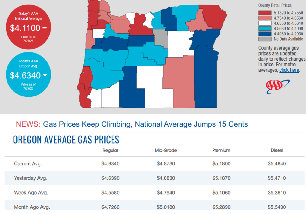
7/27/2026 — Gas Prices in Oregon Today
OSP investigating report of individuals impersonating law enforcement

CLACKAMAS COUNTY, OR– The Oregon State Police and Federal Bureau of Investigation are investigating a report of individuals impersonating law enforcement officers in Clackamas County and are asking for the public’s assistance.
There is already fear and uncertainty among immigrant communities across Oregon. OSP investigators are actively pursuing leads and conducting a thorough investigation to identify those responsible.
On Friday, July 17, 2026, between approximately 3:30 p.m. and 5 p.m., the victim was driving on Highway 211 near milepost 5, east of Woodburn, when they observed a vehicle displaying red and blue emergency-style lights behind them. Believing they were being stopped by law enforcement, the victim pulled over onto a gravel turnout.
Two men exited the suspect vehicle, one of whom was armed with a rifle. The suspects identified themselves as “ICE” and told the victim they were being detained. The victim was forcibly removed from their vehicle, searched, and placed into the back seat of the suspects’ vehicle. A third individual, who remained in the vehicle and was described as acting as a “guard,” assaulted the victim while they were detained.
After approximately 15 to 20 minutes, the suspects released the victim and told them they were free to leave.
The suspects were described as wearing boots, baseball caps, face coverings, and green long-sleeved shirts.They wore tactical vests displaying “POLICE” in white lettering and carried badges marked “Police.” The suspect vehicle was described as a newer model smaller SUV, blue or gray in color, with no visible license plates.
The victim later sought medical treatment for injuries sustained during the incident. While at an area hospital, the victim began receiving text messages from a phone number claiming to represent a law firm offering legal representation related to the incident. The messages originated from phone number 971-502-5548.
OSP investigators have contacted federal law enforcement agencies, who confirmed the individuals involved were not federal officers.
A report of individuals impersonating law enforcement officers while falsely claiming to represent federal immigration authorities may have broad impacts on immigrant communities throughout Oregon.
Anyone who witnessed suspicious activity in the area of Hwy. 211 near South Barlow Road on July 17, or anyone who may have encountered individuals posing as law enforcement officers, is asked to contact the Oregon State Police. Investigators are also interested in hearing from anyone who has received similar communications from the phone number 971-502-5548.
Anyone with information is asked to contact OSP dispatch at 800-442-0776 or OSP (677) from a mobile phone. Please reference case number SP26-237961.
OSP encourages all community members to remain vigilant, seek information from trusted sources, and report suspicious activity or individuals claiming to be law enforcement if something does not seem right. To report suspicious activity or individuals claiming to be law enforcement, contact your local law enforcement agency or call 911 in an emergency situation.
Guidance for Confirming Law Enforcement Identity — Federal agencies operating in Oregon have confirmed that officers conducting official operations must clearly identify themselves as law enforcement. They also reiterated that anyone who falsely represents themselves as a federal immigration officer will face criminal prosecution to the fullest extent of the law. Impersonating law enforcement jeopardizes public safety, creates unnecessary fear and confusion, and undermines trust in legitimate agencies.
If you are unsure whether a traffic stop or law enforcement contact is legitimate, consider the following safety tips:
- If the vehicle stopping you is not a marked unit, the emergency lights should be built in and are usually not a temporary light placed on the vehicle.
- Try to stop in a well-lit area or a location where there are a lot of people present.
- Turn on your emergency flashers, but don’t turn off your car.
- Lock your door.
- Look for a uniform or other official department clothing. If you are unsure, ask the officer to display their department identification and badge. Ask where they work and if you can contact their dispatch center to confirm their identity.
- In Oregon, local, state, and federal law enforcement officers may not wear face coverings except in specific circumstances and must clearly display identification showing the agency they represent.
- OSP also acknowledges that Oregon immigrant or refugee communities may not feel safe to do any of these things and also reminds individuals that they can always call 911 or other non-emergency line to ask for a marked vehicle to respond.
# # # About the Oregon State Police – Oregon State Police (OSP) is a multi-disciplined organization that is charged with protecting the people, wildlife, and natural resources in Oregon. OSP enforces traffic laws on the state’s roadways, investigates and solves crime, conducts postmortem examinations and forensic analysis, and provides background checks, and law enforcement data. The agency regulates gaming and enforces fish, wildlife, and natural resource laws. OSP is comprised of nearly 1,400 staff members – including troopers, investigators, and professional staff – who provide a full range of policing and public safety services to Oregon and other law enforcement agencies throughout Oregon.

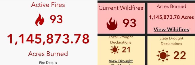
More than 30 major wildfires burning across central and eastern Oregon with a total of 70 active fires. Majority caused by two lightning events over the span of a couple weeks. Total acreage burned in the state as of today- 1.1 Million acres.
“Avoid the area”: Almost 80 miles of I-84 closed in Oregon due to wildfires
CRITICAL FIRE WEATHER CREATES HIGH FIRE DANGER
Fire Officials Seek Public Cooperation — Critical fire weather conditions, including Red Flag Watches and Warnings, are underway across the Geographic Area, creating an increased risk for rapid wildfire growth. Fire officials urge residents and visitors to help prevent wildfires by avoiding activities that could spark a fire, following local fire restrictions, and staying informed about changing conditions. The public should also monitor evacuation information and be prepared to act quickly if conditions change.
“Right now, everyone needs to be extremely careful,” said Jeff Fedrizzi, Chair of the Pacific Northwest Wildfire Coordinating Group. “Current fire conditions mean that just one spark, a discarded cigarette, or an unattended open flame can ignite the next wildfire. After the lightning we’ve received over the past 10 days and the number of new fires already burning across the landscape, we need the public’s help to prevent additional fires and protect our firefighters, our communities, and our natural resources.”
Fire officials across Oregon and Washington remind residents and visitors that fire restrictions and area closures are in place to reduce the risk of human-caused wildfires during this period of extreme fire danger. Know before you go by checking local fire restrictions and area closures before recreating outdoors. Common activities that can ignite dry vegetation include mowing dry grass, driving off designated roads, operating equipment that creates sparks, and building campfires. Many of these activities are currently prohibited or restricted because of extreme fire conditions. Stay clear of active wildfire areas and firefighting operations. Do not drive to view wildfires, as traffic can delay emergency responders, hinder firefighting efforts, and create additional safety hazards. If you encounter smoke while driving, slow down and use extra caution.
Before traveling or recreating outdoors, check the latest road closures, fire restrictions, fire activity, and evacuation information:
Road Conditions
• Oregon: TripCheck – https://tripcheck.com/
• Washington: WSDOT Real-Time Travel – https://wsdot.com/travel/real-time/
Evacuations & Emergency Alerts
• Oregon: https://oralert.gov/
• Washington: https://mil.wa.gov/alerts
Current Fire Information
• InciWeb: https://inciweb.wildfire.gov/
• Northwest Interagency Coordination Center: https://gacc.nifc.gov/nwcc/
• Air Quality: https://fire.airnow.gov/
Your decisions matter. Stay informed, follow local restrictions and evacuation orders, and help keep yourself, your community, and our firefighters safe.
After a relatively slow start to Oregon’s fire season, prolonged dry conditions with the addition of thunderstorms and strong winds last week have caused the rapid growth of wildfires in several areas of the state.
As of Saturday, a total of roughly 690,197 acres have been burned by wildfires this season.
Govenor Tina Kotek issued a preemptive emergency declaration on June 16, which allows the Oregon fire agencies to share resources. She has since issued emergency conflagration declarations for several fires, allowing for more resources to be mobilized.
The details of all major wildfires currently burning in Oregon are listed below, and information will be continually updated. Wildfires are listed by the county in which they began, but some fires or their evacuation zones extend into neighboring counties.
Fires that reach 90% containment will be removed from the list unless evacuation orders are still in effect, and some smaller fires will be excluded. Information about fire acreage and containment percentages is approximate.
The figures below are up to date as of 8:30 a.m. on Monday, July 27, 2026, unless otherwise noted.
Wheeler County
Note: The Rowe Creek Complex includes the Crosswhite East (181,443 acres), Camel Hump (6,614 acres), Parrish (404 acres) and Deep Canyon (8,089 acres) fires, all of which have physically merged.
Rowe Creek Complex
- Location: Fossil, notably east, north and west of Twickenham, along the John Day River, across Wheeler, Wasco and Crook counties
- Acreage: 208,546acres
- Cause: Lightning
- Began: July 15
- Containment: 35%
- Closures: The Bureau of Land Management closed public lands along both sides of the John Day River, from Service Creek north to the Columbia River; the National Park Service closed the Clarno and Painted Hills sections of John Day Fossil Beds National Monument.
- Evacuations: Level 3, Level 2 and Level 1 evacuations are in place; an interactive map can be found here.
- More info: Visit Wheeler County Sheriff’s Office for more evacuation information, along with their interactive evacuation map. Residents can receive updates and view evacuation zones through Genasys Protect. Check National Park closures and BLM closures at their respective websites.
Shingle Fire
- Location: 14 miles southeast of Mitchell (Wheeler, Grant and Crook counties)
- Acreage: 21,849 acres
- Cause: Lightning
- Began: July 23
- Containment: Unknown
- Closures: None
- Evacuations: Level 2 and 3 evacuations are in place; visit the Wheeler County Sheriff’s Office, Grant County Emergency Management, Crook County Sheriff’s Office or the Shingle Fire Facebook pages for more information.
Gilliam County and Sherman County
Note: The Hoag, Hopkin, McInnes, Porcupine Ridge and Wilcox Fires are now being referred to collectively as the Hay Creek Complex. The fires are burning in Gilliam, Sherman and Wasco counties. (99% contained, as of July 25) As of July 21, the McInnes and Wilcox fires merged into the Porcupine Ridge Fire. (99% contained, as of July 25) A new fire, the Cottonwood Fire, was added to the complex (0% contained) and the Little Buck Fire (0% contained) on July 23.
Hay Creek Complex
- Location: Gilliam, Sherman and Wasco counties
- Acreage: 186,730 acres
- Cause: Multiple
- Began: July 15
- Containment: 60%
- Closures: BLM land is closed near the junction of Interstate 84 and Highway 97, south along Highway 26 and near the junction of highways 27 and 20.
- Evacuations: Some evacuations were made along Scott Canyon Lane, but most of this fire’s growth has not been made toward populated areas. A temporary shelter is in place at the South Gilliam Emergency Services building in Condon.
- More info: Visit the Gilliam County Sheriff’s Office for more details.
Grant County
Salmon Fire
- Location: Southwest of Granite in the North Fork John Day Wilderness
- Acreage: 1,425 acres
- Cause: Lightning
- Began: July 8
- Containment: 60%
- Closures: The Malheur, Umatilla and Wallowa-Whitman National Forests have put temporary forest closures in place around the Salmon, Olive Butte and Anthony fires. A map of closure areas can be seen here.
- Evacuations: Level 3, Level 2 and Level 1 evacuations are in place for areas surrounding the Salmon and Olive Butte fires.
- More info: Visit the Salmon Fire OR 2026 or Baker County Sheriff’s Office Facebook pages for more information. An in-person community meeting will be held at Prairie City High School at 6 p.m. on Thursday. It will also be streamed on the Salmon Fire OR 2026 Facebook page.
Olive Butte Fire
- Location: Southwest of Granite in the North Fork John Day Wilderness
- Acreage: 3,029 acres
- Cause: Lightning
- Began: July 8
- Containment: 60%
- Closures: The Malheur, Umatilla and Wallowa-Whitman National Forests have put temporary forest closures in place around the Salmon, Olive Butte and Anthony fires. A map of closure areas can be seen here.
- Evacuations: Level 3, Level 2 and Level 1 evacuations are in place for areas surrounding the Salmon and Olive Butte fires.
- More info: Visit the Salmon Fire OR 2026 or Baker County Sheriff’s Office Facebook pages for more information.
Anthony Fire
- Location: 34 miles north of Baker City
- Acreage: 2,561 acres
- Cause: Lightning
- Began: July 8
- Containment: 89%
- Closures: The Malheur, Umatilla and Wallowa-Whitman National Forests have put temporary forest closures in place around the Salmon, Olive Butte and Anthony fires. A map of closure areas can be seen here.
- Evacuations: Level 3, Level 2 and Level 1 evacuations are in place for areas surrounding the fire.
- More info: Visit theWallowa-Whitman National Forest or Baker County Sheriff’s Office Facebook pages for more information.
Bologna Fire
- Location: 7 miles northeast of Kimberly
- Acreage: 2,338 acres
- Cause: Lightning
- Began: July 16
- Containment: 15%
- Closures: The Malheur, Umatilla and Wallowa-Whitman National Forests have put temporary forest closures in place around the fire. A map of closure areas can be seen here.
- Evacuations: None
Harney County
Egypt Fire
- Location: 12 miles north of Riley
- Acreage: 4,595 acres
- Cause: Lightning
- Began: July 16
- Containment: 68%
- Closures: None
- Evacuations: None
Baker County
Powder River Fire
- Location: 5 miles west of Richland
- Acreage: 21,026 acres
- Cause: Undetermined
- Began: July 16
- Containment: 52%
- Closures: None
- Evacuations: Level 3 and Level 2 evacuations are in place for areas surrounding the fire. Visit the state RAPTOR map for more information.
- More info: Visit the Baker County Sheriff’s Office Facebook page for more information.
Jackson County
East Evans Creek Fire
- Location: 14 miles northeast of Rogue River
- Acreage: 15,705 acres
- Cause: Vehicle into power pole
- Began: July 10
- Containment: 46%
- Closures: Traffic is closed to the public on East Evans Creek Road at Meadows Road. The BLM has issued a road closure for West Fork Evans Creek Road and Rock Creek Road. Public entry to BLM-administered lands near the fire is also temporarily prohibited.
- Evacuations: Level 1 evacuations are in place in Jackson County. An interactive map of evacuation zones can be found here.
- More info: Visit the East Evans Creek Fire entry on InciWeb for more information.
Jefferson County
Akawa Butte Fire
- Location: Southwest of Lake Billy Chinook in Jefferson and Deschutes counties
- Acreage: 26,435 acres
- Cause: Lightning
- Began: July 16
- Containment: 5%
- Closures: Road closures in place, including Indian Ford Road between Highway 20 and Meadow View Lane, as well as Wilt Road north of Buffalo Drive
- Evacuations: Level 3, 2 and 1 evacuations, including for U.S. Forest Service land, are in place. Interactive map can be seen here.
- More info: Visit the fire’s Facebook page for more details, along with Jefferson County and Deschutes County sheriff’s office Facebook pages. The Deschutes County Sheriff’s Office also has an interactive map of the evacuation zones here. Residents can receive evacuation notices via Everbridge.
Bench Fire
- Location: Four miles southwest ofWarm Springs Reservation
- Acreage: 20,180 acres
- Cause: Unknown
- Began: July 23
- Containment: 0%
- Closures: U.S. 26 is closed near Warm Springs, milepost 108 to 110.
- Evacuations: Level 3, 2 and 1 evacuations are in place; visit the Jefferson County Sheriff’s Office or the CTWS Fire Management Facebook pages for more information. Evacuation zones can be seen on this interactive map.
- More info: Shelters at The Old School Cafeteria at 1150 Warm Springs Street or St. Patrick’s Church at 341 SW J Street in Madras; livestock can be taken to the Jefferson County Fairgrounds at 430 Southwest Fairgrounds Road.
Beachcomb Fire
- Location: Four miles southwest ofWarm Springs Reservation
- Acreage: 13,648 acres
- Cause: Unknown
- Began: July 23
- Containment: 0%
- Closures: U.S. 26 is closed near Warm Springs, milepost 108 to 110.
- Evacuations: Level 3, 2 and 1 evacuations are in place; visit the Jefferson County Sheriff’s Office or the CTWS Fire Management Facebook pages for more information. Evacuation zones can be seen on this interactive map.
- Fire activity: The Beachcomb and Bench fires have merged after burning through dry fuels between the two fires. The increase in acreage reflects extreme fire behavior and recent mapping operations. Fire activity was moderate until winds increased late in the afternoon, leading to more active fire behavior. Heavy aircraft was used throughout the fire area as conditions intensified.
- Operations: Crews continue working on structure protection and strengthening dozer lines as the fire moves farther northeast.
- More info: Shelters at The Old School Cafeteria at 1150 Warm Springs Street or St. Patrick’s Church at 341 SW J
- Street in Madras; livestock can be taken to the Jefferson County Fairgrounds at 430 Southwest Fairgrounds Road.
Brewer Fire
- Location: 1 mile east of Brewer Reservoir in both Crook and Jefferson counties
- Acreage: 51,308 acres
- Cause: Lightning
- Began: July 15
- Containment: 5%
- Closures: None
- Evacuations: Level 3, Level 2 and Level 1 evacuations are in place for the Brewer and Box Springs fires; visit the Crook County Sheriff’s Office Facebook page for updated information.
- More info: Visit the Crook County and Jefferson County sheriff’s offices’ Facebook pages.
Crook County
Coyote Fire
- Location: 25 miles southeast of Prineville
- Acreage: 17,447 acres
- Cause: Undetermined
- Began: July 16
- Containment: 57%
- Closures: None
- Evacuations: Level 3 and Level 1 evacuations are in place; visit the Crook County Sheriff’s Office Facebook page for updated information or view the county’s interactive evacuations map.
- More info: Visit the Crook County Sheriff’s Office Facebook page.
Henry Fire
- Location: 2 miles south of Paulina
- Acreage: 28,827 acres
- Cause: Undetermined
- Began: July 16
- Containment: 35%
- Closures: None
- Evacuations: Level 3 evacuations are in place; visit the Crook County Sheriff’s Office Facebook page for updated information or view the county’s interactive evacuations map.
- More info: Visit the Crook County Sheriff’s Office Facebook page.
Umatilla County
Hagen Fire
- Location: South of Bingham Road
- Acreage: 26,879 acres
- Cause: Lightning
- Began: July 16
- Containment: 0%
- Closures: None
- Evacuations: Level 3, Level 2 and Level 1 evacuations are in place in Umatilla County. Visit the Umatilla County Sheriff’s Office Facebook for current evacuation information, as well as an interactive map here.
- More info: Visit the Umatilla County Sheriff’s Office Facebook.
Wallowa County
Burnt Creek Fire
- Location: 23 miles north of Enterprise
- Acreage: 3,074
- Cause: Lightning
- Began: July 17
- Containment: 0%
- Closures: Chico Trailhead in Wallowa-Whitman National Forest
- Evacuations: None
Wasco County
Grasshopper Fire
- Location: 4 miles northwest of Sportsmans Park and 3.5 miles west of Rock Creek Reservoir
- Acreage: 10,742 Acres
- Cause: Unknown, but lightning suspected
- Began: July 23
- Containment: 0%
- Closures: Several closures are in place for Mount Hood National Forest.
- Evacuations: Level 3 evacuation orders are in place for Sportsman Park, Pine Hollow and Wamic. Shelter will be at Maupin High School, as well as some Level 2 and 1 notices. See the Wasco County Sheriff’s Office Facebook or the U.S. Forest Service for Mount Hood National Forest Facebook for updates, as well as an interactive evacuation map for the county.
- More info: The Sherman County Fairgrounds, located at 66147 Lone Rock Road in Moro, will be available to shelter large animals for evacuees.
Here’s what evacuation levels mean
Level 1 Notice – Be Ready: Residents should be aware of the danger that exists in their area and monitor local media outlets for information. Residents with special needs should take note and begin making arrangements to evacuate. Evacuations at this time are voluntary.
Level 2 Notice – Be Set: This level indicates there is significant danger to your area, and residents should either voluntarily relocate to a shelter or outside of the affected area, or if choosing to remain, to be ready at a moment’s notice. Emergency services cannot guarantee that they will be able to notify you if conditions rapidly deteriorate.
Level 3 Notice – Go Now: Danger to your area is current or imminent, and you should leave immediately. Listen to local media and watch for emergency personnel who may be coming by to give further instructions regarding the evacuation.
Shelters
The Red Cross has opened multiple shelters, including:
- Burns High School at 1100 Oregon Avenue, Burns, OR 97720
- Crook County Fairgrounds (Carey Foster Hall) at 1280 South Main Street, Prineville, OR 97754
- St Patrick Catholic Church at 341 Southwest J Street, Madras, OR
- Sunridge Middle School at 700 Southwest Runnion Avenue, Pendleton, OR 97801
- Sisters High School at 1700 West Mckinney Butte Road, Sisters, OR 97759
Fire Complexes
The following fires have been grouped together as part of larger complexes, and will no longer be individually updated:
Hoag Fire (merged with Starvation Point and Lower Rock Creek fires)
- Location: South of Arlington, near the Rock Creek area
- Acreage: 50,224 acres
- Cause: Unknown
- Began: July 16
- Containment: 99%
- Closures: None
- Evacuations: Level 3, Level 2 and Level 1 evacuations are in place around and between the various fires in the Hay Creek Complex, encompassing an overall area that covers much of the western half of Gilliam County and a large portion of southeast Gilliam County, also extending into Wasco County. See the RAPTOR evacuation map for details on areas under evacuation.
- More info: Visit the Gilliam County Sheriff’s Office or Hay Creek Complex 2026 pages on Facebook for more details.
Hopkin Fire
- Location: North of Condon
- Acreage: 11,366 acres
- Cause: Unknown
- Began: July 15
- Containment: 99%
- Closures: Travel restrictions may be in place along Highway 19 near Gwendolen.
- Evacuations: Level 3, Level 2 and Level 1 evacuations are in place around and between the various fires in the Hay Creek Complex, encompassing an overall area that covers much of the western half of Gilliam County and a large portion of southeast Gilliam County, also extending into Wasco County. See the RAPTOR evacuation map for details on areas under evacuation.
- More info: Visit the Gilliam County Sheriff’s Office or Hay Creek Complex 2026 pages on Facebook for more details.
Porcupine Ridge Fire (merged with the McInnes, 456 and Wilcox fires)
- Location: 7 miles southwest of Condon
- Acreage: 80,081 acres
- Cause: Unknown, but likely lightning
- Began: July 15
- Containment: 99%
- Closures: None
- Evacuations: Level 3, Level 2 and Level 1 evacuations are in place around and between the various fires in the Hay Creek Complex, encompassing an overall area that covers much of the western half of Gilliam County and a large portion of southeast Gilliam County, also extending into Wasco County. See the RAPTOR evacuation map for details on areas under evacuation.
- More info: A temporary shelter for those affected is at the South Gilliam Emergency Services Building, located at 220 Northeast Main Street in Condon. Visit the Gilliam County Sheriff’s Office or Hay Creek Complex 2026 pages on Facebook for more details.
East Evans Creek Fire – Jackson County
The East Evans Creek Fire is now 66% contained following another day of mop-up operations across the incident. Acreage remains 15,580.
Mop-Up Progress: Crews completed 300 feet of deep mop-up work adjacent to the primary fire line. This effort systematically cools hot spots and prevents interior embers from crossing containment boundaries.
]Resource Optimization: Operational command transitioned to a Florida Complex Incident Management Team as of July 27, 2026. Crews have begun demobilizing and packing up equipment that is no longer needed on the line.
Active Evacuations: All emergency evacuation levels remain downgraded to a Level 1 “Be Ready” notice for zones JAC-016, JAC-017, JAC-026, JAC-109, JAC-124, JAC-126, JAC-147, JAC-148, JAC-149, JAC-158, and JAC-203-B.
Safety Closures: Roadblocks remain active for public safety. Traffic remains closed to the general public on East Evans Creek Road at Meadows Road, along with Bureau of Land Management restrictions on West Fork Evans Creek Road and Rock Creek Road.
Incident History: The blaze originally ignited on July 10, 2026, following a vehicle crash into a roadside utility pole. [1]
Oregon PUC invites Pacific Power customers to comment on proposed rate increase – Monday, July 27, 2026, at 6 p.m
The Oregon Public Utility Commission (PUC) is inviting Pacific Power (PacifiCorp) customers and community members to share their input on the company’s request to increase customer rates. Comments may be submitted in several ways, including during an upcoming virtual public meeting.
Comment at virtual public meeting
Held Monday, July 27, 2026, at 6 p.m. via Zoom or by phone, this meeting allows community members to learn about the proposed increase and provide spoken comments directly to the Commissioners and Administrative Law Judge overseeing this case.
If members of the public are still waiting to comment at 7 p.m., the meeting may continue to allow as many members of the public to comment as time permits.
Information on how to join the meeting can be found at: https://bit.ly/PacificPower-meeting-notice
Other ways to submit comments
Comments may be submitted through any of the following methods:
- Online Public Comment Form: https://bit.ly/UE470-public-comment-form
- Email: licComments@puc.oregon.gov” target=”_blank”>PUC.PublicComments@puc.oregon.gov
- Phone: 503‑378‑6600 or 800‑522‑2404 (all relay calls accepted)
- Mail:
Oregon Public Utility Commission
Attn: AHD – UE 470
PO Box 1088
Salem OR 973081088
About the Pacific Power rate change proposal
Pacific Power has proposed increasing the amount of money it collects from Oregon customers by $170.7 million, or about 8.6 percent overall. Actual bill impacts will vary depending on customer type (residential, commercial, or industrial) and energy usage. The company reports this increase is needed to continue investing in the electric system so it can provide safe and reliable service to its 667,000 Oregon customers. This proposed change does not include rate adjustments addressed in other proceedings before the Commission that could result in other increases or decreases to customer rates.
These investments include upgrades to transmission, distribution, and generation facilities, along with projects that improve system resiliency and customer service. In its filing, Pacific Power explains that current rates are not sufficient to cover rising operating costs or to support the company’s ability to attract investment for future system upgrades.
Pacific Power’s general rate case filing is undergoing a nearly year-long review and will be fully investigated on behalf of customers by the PUC, the Oregon Citizens’ Utility Board, and others. This public meeting is part of that review. The Commission will issue a final decision in March of next year and any approved rate changes would take effect on April 4, 2027.
OHA urges people to limit smoke exposure as wildfire season intensifies
Health officials concerned about poor air quality, effects on sensitive populations as blazes rage across Oregon
| What you should know:Wildfire season is creating hazardous air quality conditions across Oregon. Wildfire smoke contains particles that can irritate eyes, lungs, and other organs and have a severe impact on people with chronic conditions. People can stay safe by keeping windows and doors closed, using HEPA filters if available, and avoiding outdoor activity. |
With nearly 80 wildfires burning across Oregon, air quality is poor in many areas of the state. But there are steps people can take to protect themselves and their loved ones from wildfire smoke exposure.
“Smoke from wildfires can travel hundreds or thousands of miles, and some people—especially those with chronic conditions like lung disease or heart disease—can have a pretty severe reaction to even small amounts of smoke,” said Gabriela Goldfarb, manager of the Environmental Public Health Section at Oregon Health Authority’s Public Health Division.
Wildfire smoke exposure risks – Wildfire smoke, like other sources of air pollution, can irritate eyes and lungs and cause everyone to experience symptoms such as coughing and watery eyes, which often clear up once the smoke passes.
Smoke is made up of very small particles that can travel into the bloodstream to people’s lungs, heart, and other organs.
Scientists are concerned about particulate matter that is 2.5 microns in size and smaller, known as “PM 2.5.” Thirty PM 2.5 strung together are the width of a human hair.
“That’s how small we’re talking here. It is very well-documented that PM 2.5 exposure can decrease lung function, aggravate asthma, cause irregular heartbeat and heart attacks, and cause premature death in people with heart or lung disease,” Goldfarb said.
People most impacted – In addition to those with chronic conditions, groups sensitive to wildfire smoke include older adults, infants and children, people who are pregnant and those who regularly smoke. Outdoor workers and athletes are also at higher risk.
Low-income families who struggle with access to health care and protective housing may also experience worse effects of wildfire smoke, Goldfarb said.
Children are a particularly sensitive population, because they inhale more smoke per pound of body weight than adults, and their lungs and other organs are still developing.
How to stay safe – Smoke levels can change rapidly depending on weather. OHA reminds people to check conditions on the Oregon Smoke Information Blog, view Oregon DEQ Air Quality Index or download the free OregonAIR app on the Apple App Store or Google Play store and search for alerts in their communities.
If reports show high smoke levels, take the following steps:
- Stay indoors whenever possible.
- Create cleaner air spaces.
- Keep windows and doors closed.
- Avoid strenuous outdoor activity.
- Use high efficiency particulate air (HEPA) filters in indoor ventilation systems or portable air purifiers, if available, or create a DIY Box fan filter.
- When driving, set your car’s ventilation to “recirculate.”
- If you live with chronic lung or heart conditions, follow your management and treatment plan. Call your health care provider if your condition worsens due to smoke exposure. Relocate to an area with cleaner air if you can.
- Keep track of medication, refill prescriptions if needed, and keep an eye on personal health.
Many communities open cleaner air spaces during severe smoke events to help people unable to create a cleaner air space at home. In partnership with local officials and organizations, 211Info maintains a list of public cleaner air spaces. For more information:
- Dial 2-1-1 or 1-866-698-6155 – both lines are available 24 hours a day.
- Text the area zip code to 898211 (TXT211) – available Monday through Friday from 9 a.m. – 5 p.m.
- Visit https://www.211info.org/
Remember that cloth, dust, and surgical masks do not protect against harmful particles in smoke. NIOSH-approved N95 or P100 respirators may offer protection, but they must be properly fitted and worn. They won’t work for everyone, especially children.
For more information on reducing exposure to wildfire smoke, including fact sheets and FAQs in multiple languages, visit OHA’s Wildfires and Smoke page.
Oregon emergency alert system more popular in rural areas than metro area, study says
Participation in Oregon’s voluntary statewide emergency alert system designed for natural disasters and public safety threats has been far higher in rural counties than in the Portland metro area, according to a new study.

A new study details emergency alert efforts in Oregon to respond quickly to natural disasters.
(Courtesy Oregon Hazards Lab)
Researchers from the Ohio-based Miami University published their findings on Monday in Disaster Prevention and Management: An International Journal. They found that the OR-Alert system has “surprisingly” high enrollment rates above 100% from counties such as Clatsop, Curry, Douglas, and Lincoln, while the Multnomah County area had an enrollment rate of 13% that mostly included “internal Portland employees.” The rates above 100% are likely due to people signing up for the alerts more than once.
“Enrollment also varied geographically, with some rural counties reporting surprisingly high participation rates, while urban areas like Multnomah County showed low participation, leaving large populations more vulnerable,” the study reads.
That’s a reflection of the fact that natural disasters such as landslides and floods are more common in rural Oregon in comparison to the Portland metropolitan area.
The OR-Alert system kicked off in Oregon in 2021 and allows people to visit a statewide portal to connect with local emergency alert systems in all 36 counties and tribal governments across the state who rely upon a universal mass notification service. The system allows for local emergency notification managers to coordinate with the Federal Emergency Management Agency, or FEMA, which can send alerts to all cell phones in a given area.
While more than 50% of the alerts the system sent out use text messaging, push notifications were “underutilized” at 2%, posing “substantial barriers for time-sensitive earthquake warnings,” according to researchers. They said the geographic and notification-type disparities represent barriers to risk reduction.
“Institutional coordination between emergency management, public health, and community organizations can build the engagement and trust necessary for effective warning response,” the study reads.
The U.S. Geological Survey offers another tool that delivers automatic notifications to people on their cellphones ahead of damaging earthquakes at their locations. That is not an opt-in tool, but recipients must allow their cell phones to receive emergency alerts in their settings. (SOURCE)

Investigators Serve Ashland Search Warrant After Unidentified Suspect Sent Thousands of Child Sexual Abuse Material Images to Undercover Agent

ODOJ Case CJD0550-26 ASHLAND, Ore. – The Southern Oregon Child Exploitation Team (SOCET) along with the Oregon Department of Justice’s (ODOJ) Internet Crimes Against Children (ICAC) Task Force and Ashland Police Department (APD) served a search warrant Wednesday morning in Ashland. The task force served the search warrant after SOCET investigators received over 2000 images of Child Sexual Abuse Material (CSAM) images directly from an unidentified suspect.
On scene, investigators interviewed potential witnesses and involved parties. SOCET investigators are working to identify the suspect. Once identified, investigators will refer criminal charges to the Jackson County District Attorney’s Office.
SOCET served the search warrant Wednesday, July 22 at an apartment in the 400 block of Russell Street in Ashland. Jackson County Sheriff’s Office (JCSO), Homeland Security Investigations (HSI), Medford Police Department (MPD), APD, Central Point Police Department, Talent Police Department, ODOJ ICAC, and the Southern Oregon High Tech Crimes Task Force (SOHTCTF) assisted with the warrant service. During the warrant, investigators seized digital devices which will be forensically examined by SOHTCTF for further evidence of child exploitation.
SOCET is a joint inter-agency task force that started in June of 2020 to combat child exploitation. The task force consists of investigators from JCSO, MPD, ODOJ ICAC, and HSI, as well as prosecutors from our local, state, and federal law enforcement partners in Jackson County. SOHTCTF is a joint inter-agency task force that consists of investigators from JCSO, HSI, and MPD.
Investigators continue to examine seized devices and interview witnesses as the investigation moves forward. No further details will be released at this time.
L. L. Stub Stewart and Rooster Rock State Parks will host OMSI Star Parties this summer

— L.L. Stub Stewart and Rooster Rock State Parks will celebrate the night sky with free stargazing parties in July, August and September.
The parks are partnering with OMSI and Rose City Astronomers to host an OMSI Star Party 2026, which includes a presentation at dusk and stargazing from 9 to 11 p.m. Telescopes will be provided by volunteers, and visitors are welcome to bring their own. Depending on the weather, stargazers will search out stars, the moon, and planets.
“We love helping people experience the park in a different way. After dark, everything feels calmer, quieter, and a little more magical,” shared Park Ranger Jeremy Williams at L. L. Stub Stewart State Park.
These events are free. Parking in the day-use areas requires a $10 parking permit per vehicle or you can use an annual parking pass if you have one.
Visitors are encouraged to bring their own chairs, blankets, warm clothing, snacks and water. Bug repellent is always a good idea. Please use red flashlights to avoid interfering with the dark sky viewing. You can also cover your flashlight or smartphone with red electrical tape.
Star maps will be provided along with recommended astronomy apps that visitors can load on their phones if interested.
Visitors should arrive early to familiarize themselves with the area and park only in designated spaces. Overnight camping is not permitted in day-use areas, though campground reservations are available at stateparks.oregon.gov.
On the scheduled day for OMSI Star Parties, visitors should visit the OMSI website for possible weather-related cancellations. The long-range forecast looks promising for excellent viewing.
“Whether you come to Rooster Rock to count Perseids or simply to spend a peaceful evening under the stars, the meteor shower is a wonderful excuse to slow down, look up, and experience the Gorge in a whole new light”, said Park Ranger Elika Paki at Rooster Rock. “And if you lose track of how many shooting stars you’ve seen, don’t worry, that just means you’re doing it right.”
All events begin at dusk. We recommend arriving early to accommodate parking. Parks will close at 11:45 p.m.
Perseid Meteor Shower Watch | Wednesday, August 12
- L. L. Stub Stewart State Park
- Rooster Rock State Park
Equinox Celebration | Saturday, September 12
- L. L. Stub Stewart State Park
You can find additional details about the event, parking logistics, whether pets are allowed, and how to request accessibility accommodations on the L.L. Stub Stewart State Park and Rooster Rock State Park event pages, and the OMSI event page.
Oregon State Parks often hosts stargazing events across the state. More opportunities can be found on Oregon State Parks’ event page.
Public invited to comment on plan to possibly triple logging in eastern Oregon national forests
The U.S. Forest Service’s proposed revisions to the Blue Mountain Forest Plan would allow more logging and taking older trees in the name of wildfire prevention
Officials at the U.S. Forest Service are proposing new management plans for eastern Oregon’s Blue Mountains that include potentially tripling the amount of logging across 5.5 million acres in the next decade.

The Forest Service published a draft of proposed changes to the 35-year-old Blue Mountain Forest Plan last week. It would allow more logging, mining and grazing across four national forests spread across eastern Oregon, as well as parts of southeast Washington: the Malheur, Ochoco, Wallowa-Whitman and Umatilla National Forests.
The public has until Sept. 30 to submit comments on the 350-page draft proposal.Submit comments on the revised Blue Mountain Forest Plan here.
The draft plan describes increases in logging and animal grazing as important to local economies and to preventing wildfire.
It predicts everything from habitat conservation to forest carbon storage would improve over the long term if more logging is allowed because strategically logging and grazing parts of the forest would prevent wildfire, which officials characterize as the biggest threat to habitat and forest loss.
Environmental advocates disagree with the framing.
The Blue Mountains encompass Oregon’s largest protected wilderness areas. Conservation groups have expressed concern and outrage over the draft management plan, which they say could exacerbate area drought and water quality issues, wildfire risks and impact habitat for elk, wolverine, wolves, moose, owls and salmon.
“This plan seeks to open up and pillage one of the wildest places left in the U.S.,” Lauren Anderson, a climate forests manager at the nonprofit Oregon Wild, said in a statement. “The Trump administration is already taking a hatchet to protections for water, wildlife and the public’s voice. This plan is that philosophy in action, putting at risk the very values that make the Blue Mountains special.”
Bev Law, a forest scientist and professor emerita at Oregon State University who has studied extensively the potential forest carbon storage in Oregon forests, found that protected wilderness areas in the Blue Mountains contain the second highest proportion of above-ground carbon stocks in all of Oregon’s protected wilderness areas.
Nick Smith, a spokesperson for the American Forest Resource Council, a trade association representing the timber industry, said in a statement that the group is still reviewing the proposed updates but that change is overdue.
“These national forests face some of the highest wildfire, insect and disease risks in the West. At the same time, the region is steadily losing the sawmills, logging contractors and the skilled workforce needed to carry out active forest management and provide markets for the material that needs to come out of the woods,” he said.
The draft Blue Mountain Management Plan proposal also includes rescinding a 32-year-old rule called the Eastside Screens that prohibits logging trees that are 21 inches in diameter or larger on six eastern Oregon and Washington national forests. Forest Service officials attempted to rescind the rule during the first Trump administration, but conservation groups sued and it was blocked by a federal judge.
Forest Service officials have argued that some younger trees that grow fast should be able to be removed even if they are more than 21 inches in diameter, because they are crowding out other tree species that take longer to grow but are important to the forest ecosystems.
The proposal also assumes Congress will soon rescind the 25-year-old Roadless Rule, which prohibits road construction, logging and mining on roughly 60 million acres of public land, including about 2 million acres of forests in Oregon. That alone would increase the amount of land classified as open for logging in the Blue Mountains by 17%, according to the draft.
Most of the increased logging would take place in the Malheur National Forest, followed by the Wallowa-Whitman and then Umatilla national forests. (SOURCE)
The Oregon Division of Financial Regulation has issued a warning regarding a newly identified fraud ring that enrolls individuals in life insurance policies without their awareness or consent.
This fraudulent activity primarily targets older adults and has been reported across several states, including Oregon. The scheme involves licensed insurance agents who initiate contact with victims through multiple telemarketing calls, during which personal information is solicited. This information is subsequently passed on to the participating insurance agents, who then reach out to the victims to gather any additional details necessary to finalize an application for a life insurance policy.
These applications are submitted without the victims’ knowledge, resulting in the issuance of one or more policies for which the agents receive commissions, despite the fact that the premiums have not yet been paid. The fraud typically comes to light when the insurance company seeks the initial premium payment.
The Division of Financial Regulation’s consumer advocates are available to assist with inquiries or to facilitate the filing of complaints. They can be contacted at 1-888-877-4894 or via email at DFR.InsuranceHelp@dcbs.oregon.gov for insurance-related assistance, and dfr.financialserviceshelp@dcbs.oregon.gov for help with financial services.
Check out Oregon State Parks with your library card
Borrow an Oregon State Parks parking permit for free at 82 libraries statewide.

– Oregon Parks and Recreation Department (ORPD) and the State Library of Oregon are partnering to offer free state parks parking permits to Oregon public libraries. There are currently 200 parking permits available at 82 libraries across the state.
“Oregon’s state parks are for everyone,” said OPRD deputy director JR Collier. “As we assess ways to manage our budget responsibly, we also want to uplift equitable access to our parks.”
Each participating library received up to four parking permits. These are the physical hang tags you check out from the library and put in your car. The permit covers parking in all Oregon State Parks day-use areas for one vehicle. Go to the Oregon State Parks website to find participating libraries. All you need to participate is your library card.
“Libraries help make life more affordable for Oregonians. This program leverages the existing borrowing system to help connects folks of all income levels with the beauty and splendor of Oregon’s State Parks,” said Wendy Cornelisen, State Librarian.
Both OPRD and the State Library contributed 100 parking permits to the program to distribute to libraries. The agencies determined how many passes each library would receive based on interest from the library, its proximity to a park charging a day use fee, and the size of the population it serves. The State Library purchased permits with Library Services and Technology Act funds from the federal Institute of Museum and Library Services.
OPRD first distributed parking permits to 28 libraries as part of a year-long pilot program starting in August 2024. Those passes were checked out more than 2,100 times. At the pilot’s conclusion, OPRD evaluated how to best move the program forward in the context of its changing fees. In 2027, OPRD and the State Library will continue to explore options for an expanded long-term program that will serve even more libraries and people in Oregon. Learn more about the OPRD Library Pass Program.
Weekend Train Rides Return to the Oregon Rail Heritage Center for the 2026 Season

PORTLAND, Ore. — The Oregon Rail Heritage Center is excited to announce the return of its popular weekend train rides. Running every Saturday and Sunday through October 11, 2026, these family-friendly excursions offer passengers a memorable rail adventure through the heart of Portland aboard historic diesel locomotive BNSF 3613.
About Oregon Rail Heritage Center:
The Oregon Rail Heritage Center (ORHC) provides for the preservation, operation and public enjoyment of Portland’s historic locomotives, railroad equipment, and artifacts, and educates the public about Oregon’s rich and diverse railroad history. ORHC is open to the public on Thursdays-Sundays from 1:00pm-5:00pm. Seasonal train excursions are offered most weekends. For additional information, visit https://orhf.org/. Follow us on Facebook and Instagram.
Oregon Department of Veterans’ Affairs
No veteran should be without a place to call home, and the Oregon Department of Veterans’ Affairs is committed to ending veteran homelessness in our state. The new ODVA Houseless Veterans Program collaborates with federal, state, county, and Tribal agencies, veteran services offices, and community homeless service providers to meet the urgent and unique needs of Oregon’s diverse veteran communities challenged with housing stability. In addition to advocating for Oregon veterans experiencing or at risk for houselessness, the program provides direct service to veterans and their families seeking federal and state veterans’ benefits, including access to local VA health care, documentation of service, as well as other available state benefits, and local homeless services organizations and low-income assistance programs. If you or a veteran you know is dealing with homelessness, contact the ODVA Houseless Veterans Coordinator today at houselessvets@odva.oregon.gov or visit https://ow.ly/V4EH50VnL93 to learn more.
Staying Informed During a Communications Outage: Best Practices for the Public
Disasters can damage critical infrastructure, leading to temporary outages in cell service, internet, and power. When communication systems go down, it’s vital to be prepared with alternate ways to get emergency information and stay connected. Here’s how you can prepare and respond:
Have a Battery-Powered or Hand-Crank Emergency Weather Radio
- Why it matters: Emergency radios can receive Emergency Alert System (EAS) broadcasts via AM/FM or NOAA Weather Radio frequencies—even when cell towers and the internet are down.
- Note: Emergency radios do not receive Wireless Emergency Alerts (WEA) like cell phones do. Tip: Pre-tune your radio to your local emergency broadcast station (e.g., OPB in Oregon or NOAA frequencies).
Turn On WEA Alerts on Your Phone
- Make sure Wireless Emergency Alerts (WEA) are enabled in your phone’s settings. These alerts include evacuation orders, severe weather warnings, and other urgent notifications.
- WEA messages are sent through cell towers—if cell service is out, WEA alerts will not be delivered. This is why having backup methods like a radio is essential.
Charge Everything in Advance and Have Backup Power
- Charge phones, power banks, laptops, and rechargeable flashlights before fire weather conditions worsen.
- Consider solar-powered chargers or car chargers as backups.
- If you are sheltering in place, a generator (solar or gas powered) is helpful.
Know Your Evacuation Routes in Advance
- Save printed or downloaded evacuation maps in case you can’t access GPS or navigation apps.
- Most mapping services (like Google Maps or Apple Maps) offer the ability to “Make maps available offline.” Download your area in advance so you can navigate even if cell towers or internet access are down.
- When in doubt, call 511 or visit the TripCheck.com website if you have cell service.
- Don’t wait for a notification—if you feel unsafe, evacuate early.
Print or Write Down Critical Contacts and Info
- Phone numbers of family, neighbors, and local emergency contacts.
- Address of evacuation shelters, veterinary services (for pets/livestock), and medical facilities.
- Your own emergency plan, including meeting locations.
- Have copies of vital documents in your go-bag and take video of your property (inside and out) for insurance claims later.
If Calling 9-1-1 Over Wi-Fi or Satellite, Check Your Location Settings
If you call 9-1-1 using Wi-Fi calling or a satellite-connected phone (like an iPhone or Android), your location might not be automatically visible to dispatch. Instead, it may rely on the emergency address saved in your phone’s settings.
- Update this emergency address when you travel or relocate—especially in evacuation zones or rural areas.
- Most importantly, always tell the dispatcher exactly where you are—include your address, landmarks, road names, or mile markers to help first responders reach you quickly.
Sign Up for Alerts Before There’s an Outage
- Register for OR-Alert and your county’s local alert system.
- Follow your local emergency management officials’ and bookmark resources like: wildfire.oregon.gov.
Prepare for Alert Delays or Gaps
- Know the three levels of evacuation:
- Level 1 – Be Ready
- Level 2 – Be Set
- Level 3 – GO NOW
- If you hear a siren, see a neighbor evacuating, or witness fire behavior increasing—take action even if you haven’t received an alert.
Be Your Own Info Network
- Check on neighbors, especially seniors or those with disabilities.
- Post printed signs with updates for those passing by.
In rural areas, community bulletin boards or fire stations may serve as local information points. Support and Restoration in Progress To help maintain emergency communications during this incident, OEM deployed eight Starlink terminals under the guidance of ESF 2 and the Statewide Interoperability Coordinator (SWIC). A Communications Technician (Jeff Perkins) was also deployed to assess connectivity needs on the ground. These Starlink terminals have been providing service to the Lake County Emergency Operations Center (EOC), Oregon State Police (OSP), Warner Creek Correctional Facility, and will soon support the town of Lakeview, the Bureau of Land Management (BLM), and the Lakeview Ranger Station. OEM’s Regional Coordinator (Stacey) is also on-site supporting the Lake County EOC. Coordination has been strong across local, state, and private sector partners. *** Update: As of 7/10/25 at 1:47 PM, fiber service has been restored.
Reconnect When Service Returns
- Once communications are restored, check official websites:
- Oregon.gov/oem
- Your county emergency management page
- TripCheck.com for road conditions
- Share verified info—not rumors—on social media or community pages.
Prepare for Delays in Restoration
- Communication may come back in phases. Damage to fiber lines or cell towers can take time to repair.
- Continue using backup methods and stay alert for updates via radio or in-person notices.
Final Tip:
In an emergency, CALL 9-1-1 to report life-threatening danger, not for general information. Use local non-emergency numbers or go to physical information points if needed. You can find more tips for preparing in OEM’s Be2Weeks Ready toolkit.

https://www.oregon.gov/osp/missing/pages/missingpersons.aspx
Oregon’s Missing Persons
Many times you’ll see postings without case numbers or police contact. There is rarely a nefarious reason why (the nefarious ones are pretty obvious). Usually the loved one tried to call to report their missing person and they are either refused or told to wait a day or two by people who are unaware of SB 351 and the laws that they are bound to when answering the phone. Many people don’t bother calling LE if their loved one is homeless or in transition because they believe LE won’t care. The biggest myth is the 24 hour rule.
In Oregon we don’t have those rules and an officer or person answering the phone is not allowed to decide. The law decides. We have Senate Bill 351 and it states that the police CANNOT refuse a request for any reason and they must begin working on it within 12 hours. The person making the report does not have to be related to missing person either.
Here is SB 351 written by families of the missing here in Oregon in conjunction with Oregon law enforcement officers. This should be common knowledge, please make it this way. https://olis.oregonlegislature.gov/…/SB351/Introduced


Contact us: Info@OregonBeachMagazine.com
Find the mental health support you need

Click to see all resources https://oregonhealthnews.oregon.gov/find-the-mental-health-support-you-need/?utm_medium=email&utm_source=govdelivery