

The latest news stories across the state of Oregon from the digital home of the Oregon coastal cities, OregonBeachMagazine.com
Monday, August 24, 2026
Oregon Beach Weather



Here’s the overview of our weather outlook, but be sure to check out what we’re predicting in your area: https://www.farmersalmanac.com/extended-forecast
Please pay close attention to the weather conditions across the state.
It’s extremely dry. Our ask: prevent sparking a wildfire. Check your tow chains. Don’t mow tall dry grass in the heat of the day Don’t park on tall dry grass
We’ve got prevention tips posted to our website to share with your friends and family. LEARN MORE: https://www.oregon.gov/…/pages/prevent-wildfires.aspx
Please remember:– Don’t park on dry grass– Avoid dragging chains or towing equipment that can create sparks– Use caution with outdoor equipment– Report smoke or suspicious fire activity immediately
Important Links:
 Emergency Alerts: https://member.everbridge.net/76864345342052/login
Know Your Zone: https://protect.genasys.com/search
Emergency Kits: https://rvem.org/Get-Ready-Rogue/Kit-Types
WatchDuty: https://app.watchduty.org/
Wildfire prevention starts with each of us. One careless moment can have lasting consequences for firefighters, communities, and our public lands. Stay informed. Stay prepared. Stay fire aware.

Tillamook Air Museum Announces Partnership with Vintage Aviation Museum
The Port of Tillamook Bay Commissioners have approved a term sheet for the land lease and future sale of Tillamook’s historic World War II-era Hangar B to Vintage Aviation Museum, a Utah-based 501(c)(3) nonprofit organization.

With Vintage Aviation Museum set to assume operation of the Museum from the Port of Tillamook Bay and become its future owner and operator, an exciting new chapter is beginning for the Museum. 𝘽𝙪𝙩 𝙤𝙣𝙚 𝙞𝙢𝙥𝙤𝙧𝙩𝙖𝙣𝙩 𝙩𝙝𝙞𝙣𝙜 𝙬𝙞𝙡𝙡 𝙣𝙤𝙩 𝙘𝙝𝙖𝙣𝙜𝙚: 𝙬𝙚 𝙬𝙞𝙡𝙡 𝙘𝙤𝙣𝙩𝙞𝙣𝙪𝙚 𝙩𝙤 𝙗𝙚 𝙩𝙝𝙚 𝙏𝙞𝙡𝙡𝙖𝙢𝙤𝙤𝙠 𝘼𝙞𝙧 𝙈𝙪𝙨𝙚𝙪𝙢.
Our identity is deeply connected to Tillamook, Naval Air Station Tillamook, historic Hangar B, and the people and stories that have shaped this remarkable place for more than eight decades. Preserving and sharing that history will remain at the heart of everything we do.
Work is already beginning behind the scenes as we are preparing to welcome visitors back to the museum. We look forward to sharing a reopening date as plans move forward.Vintage Aviation Museum plans to relocate most of its aircraft collection to Tillamook, bringing additional historic aircraft to Hangar B and expanding the Museum’s aviation collection. Looking ahead, the vision is to utilize the entire historic blimp hangar for aviation-related exhibits, aircraft displays, preservation, education, and visitor experiences.
The future of historic Hangar B will remain a priority. Following the Museum’s reopening, efforts will continue toward the repair, restoration, and long-term preservation of this extraordinary piece of Oregon and American aviation history so that it can be preserved and enjoyed by visitors for generations to come.
At the Tillamook Air Museum, we have always believed in thinking big, taking chances, and finding new ways to bring aviation history to life. Operating as part of a nonprofit organization will provide greater flexibility to pursue new opportunities, partnerships, funding sources, and projects as the Museum moves forward. Visitors can expect us to keep pursuing ambitious projects exploring new ideas and creating opportunities that keep the Museum moving forward.
Just as importantly, we will continue strengthening our connection with the community we call home. Education and outreach will remain an important part of our mission, including working with local schools and developing partnerships throughout our community.
We want to recognize and thank the Port of Tillamook Bay, which has owned and operated the Tillamook Air Museum for more than a decade. We have enjoyed a strong and supportive relationship with the Port, and the Museum would not be what it is today without their trust, support, and belief in our mission.
We are deeply grateful for everything they have done to help us grow and look forward to continuing that relationship into the future. Our relationship with the Friends of the Tillamook Air Museum (FOTAM) will remain an important part of our future. FOTAM’s volunteers have provided tremendous support to the museum and its mission, and we are incredibly grateful for their dedication and hard work. We look forward to continuing our strong partnership with FOTAM as we move forward together.
For those who would like to be part of this next chapter, contributions to Vintage Aviation Museum can help support exhibit preparation, restoration, and other work associated with preparing the Tillamook Air Museum to once again welcome the public.
𝙎𝙪𝙥𝙥𝙤𝙧𝙩 𝙩𝙝𝙚 𝙏𝙞𝙡𝙡𝙖𝙢𝙤𝙤𝙠 𝘼𝙞𝙧 𝙈𝙪𝙨𝙚𝙪𝙢 𝙩𝙝𝙧𝙤𝙪𝙜𝙝 𝙑𝙞𝙣𝙩𝙖𝙜𝙚 𝘼𝙫𝙞𝙖𝙩𝙞𝙤𝙣 𝙈𝙪𝙨𝙚𝙪𝙢: https://www.zeffy.com/…/7577fb8f-4c8d-4f84-94d9… We look forward to what comes next and, most importantly, to welcoming you back to the Tillamook Air Museum.Additional information, including updates on our progress and a reopening date, will be shared as plans move forward.
𝘼𝙗𝙤𝙪𝙩 𝙑𝙞𝙣𝙩𝙖𝙜𝙚 𝘼𝙫𝙞𝙖𝙩𝙞𝙤𝙣 𝙈𝙪𝙨𝙚𝙪𝙢 The Vintage Aviation Museum is a Utah-based 501(c)(3) nonprofit organization dedicated to preserving historic aircraft, aviation artifacts, and the stories of the people who shaped aviation history. Through preservation, education, exhibits, and visitor experiences, the museum works to ensure that America’s aviation heritage remains accessible to future generations.
𝘼𝙗𝙤𝙪𝙩 𝙏𝙞𝙡𝙡𝙖𝙢𝙤𝙤𝙠 𝘼𝙞𝙧 𝙈𝙪𝙨𝙚𝙪𝙢Housed in historic World War II-era Hangar B, the Tillamook Air Museum is a dynamic and ever-changing aviation museum dedicated to bringing history to life. Featuring a diverse collection of historic aircraft, immersive displays, hands-on interactive exhibits, and unique visitor experiences, the museum shares the remarkable story of Naval Air Station Tillamook while exploring aviation and military history from across the nation and around the world. The Tillamook Air Museum believes history should be experienced, not simply observed, and continues to find new and exciting ways to make the past accessible, educational, and fun for visitors of all ages.
The Oregon Coast Humane Society Veterinary Clinic is celebrating its first year of providing accessible veterinary care with a community ribbon cutting on Thursday, Aug. 27, from 4 to 6 p.m. at 1739 Twenty-Second Street in Florence.
The celebration marks the one-year anniversary of the clinic’s first surgeries following the Oregon Coast Humane Society’s purchase of the former veterinary hospital earlier in 2025. Since opening, the clinic has provided care to more than 1,600 community animals.
Florence Food Share Invites Artists to Create Signature Piece for Empty Bowls 2026

Florence Food Share is seeking a local artist to create the featured artwork for the 30th Annual Empty Bowls fundraiser, taking place the first weekend of December.
For more than a decade, an original work by a local artist has been the centerpiece of the Empty Bowls poster and is later raffled off during the event to help raise additional funds for Florence Food Share. This special tradition celebrates local creativity while supporting the organization’s mission of ensuring no one in our community goes hungry.
Artists working in any medium are encouraged to submit a concept, provided the finished piece can be professionally photographed for promotional materials and donated to Florence Food Share. The artwork should capture the spirit of Empty Bowls and reflect the event’s message: “Because no one should go hungry.”
The selected artist will be recognized in event marketing and media coverage and will receive a tax deduction for the donated artwork.
To be considered, artists should email a brief description of their concept, the intended medium, and a photo of a previous work to Kim Pickell at kpickell63@gmail.com. The submission deadline is September 4, 2026, and the completed artwork is due October 2, 2026.
Bandon Police Department · PRESS RELEASE  Public Safety Warning: Power Line Wire Theft in the greater Bandon area

We are warning residents about a recent rash of power line thefts in the greater Bandon area, including Coos & Curry counties involving individuals illegally cutting and removing wire from utility infrastructure.
These incidents are extremely dangerous. Cutting power lines can result in severe injury or death, not only to the person attempting to remove the wire but also to nearby residents, utility workers, and members of the public.
Damaged power lines and utility equipment can also create an extreme risk of fire, particularly in dry conditions.
Residents are asked to remain alert and report suspicious activity around utility poles and power infrastructure.If you see someone near a utility pole or power line who does not appear to be a legitimate utility worker, please contact law enforcement immediately. Do not approach or confront the individual.
Anyone who observes suspicious activity should note the location, description of the person or vehicle, and direction of travel, if it can be done safely.
Cutting or tampering with power lines is a serious felony criminal offense and may result in felony charges which may include, Domestic Terrorism in the 1st Degree. Depending on the circumstances and applicable law, additional serious charges may also be considered.
The safety of our community depends on everyone remaining vigilant. If you see something suspicious, please report it rather than putting yourself at risk.If you see suspicious activity involving utility infrastructure, call police immediately.
Thursday night, Seaside Fire & Rescue responded to a report of a subject stranded along the rugged west coastline of Tillamook Head.
Responding crews coordinated with the U.S. Coast Guard and staged at the Surfers Parking Lot in the Cove. Cannon Beach Police Department arrived shortly after and launched a drone in an attempt to locate the subject. Due to poor weather conditions, the drone was unable to reach the area indicated by the subject’s GPS coordinates.
The U.S. Coast Guard launched both a Motor Lifeboat and Helicopter while Seaside firefighters began hiking toward the provided GPS location. Cannon Beach Fire District was requested to assist with additional personnel for the search.After approximately an hour and a half of hiking through rocky, uneven terrain, crews were able to establish voice contact with the subject and locate them shortly afterward. The subject was uninjured but fatigued.
Although the Coast Guard helicopter was overhead, weather conditions and the subject’s location prevented crews from safely conducting a hoist. Firefighters began escorting the subject back out on foot. After another three hours navigating the rocky, uneven terrain, crews and the subject safely reached the Surfers Parking Lot. The subject was evaluated and did not require medical treatment.
We appreciate the assistance and teamwork from Cannon Beach Fire District, Cannon Beach Police Department, and the United States Coast Guard throughout this incident.Responding Fire & Rescue units:3156 — Rescue3251 — Rescue3163 — Chief Officer3202 — Chief Officer
Coastal Hiking Safety:Tillamook Head and other areas along the Oregon Coast can present serious hazards, especially when hiking near the shoreline. Before heading out:• Check tide tables and weather conditions before your hike.• Be aware of incoming tides, sneaker waves, and heavy surf that can quickly cut off your route back.• Avoid climbing or traveling on wet, unstable cliffs and rocks.• Stay on established trails whenever possible.• Carry a charged phone and consider bringing a portable battery.• Tell someone where you’re going and when you expect to return.• Give yourself plenty of daylight and never rely on the beach as an exit route without knowing the tides. Conditions along the Oregon Coast can change quickly. Plan ahead, know your route, and always give the ocean plenty of space.
Coos County Sheriff’s Office ·***Press Release***Case #: S2026-01331
Coquille, OR – On August 21st, 2026, at 10:00 p.m., a Coos County Sheriff’s Deputy conducted a traffic stop of a vehicle on U.S. Hwy 42 near Dillard Drive just outside of Coquille for a traffic violation.
During the traffic stop, it was learned that a passenger in the vehicle, Harley J. Lee (26), was in violation of a court order by being in the same vehicle as the operator, who was a protected person in the court order.
As a result, Harley J. Lee (26) was arrested on Violation of a Court Order (ORS 135.290 Contempt of Court) and transported to the Coos County Jail, where he was booked. “Police action is not indicative of guilt. All persons are presumed innocent until proven guilty in a court of law.”
ODFW to Host Public Meetings in Tillamook And Port Orford On Commercial Nearshore Fisheries

The Oregon Department of Fish and Wildlife is holding two public meetings to discuss the commercial black and blue rockfish and nearshore fisheries. The meetings will be held in person with virtual or phone-in options Sept. 2 in Tillamook and Sept. 3 in Port Orford.
ODFW commercial fishery managers will give an update on federal management and stock assessments and review the 2026 commercial fishery. The agenda also includes:
- Federal management and stock assessment update.
- Review of 2026 fishery.
- Options for setting 2027 bi-monthly vessel catch limits.
- Input from industry and other interested parties.
Both meetings are held 6:30 p.m. – 8:30 p.m. with virtual options on Microsoft Teams from your computer, tablet, or smart phone.
Sept. 2: Tillamook
In person: ODFW North Coast Watershed District Office, 4907 Third St.
Virtual Teams option: https://tinyurl.com/ODFWCNS2026TL
Phone in option: dial +1 503-446-4951; conference ID: 996 763 370#
Sept. 3: Port Orford
In person: Port Orford Library, 1421 Oregon St.
Virtual Teams option: https://tinyurl.com/ODFWCNS2026PO
Phone in option: dial +1 503-446-4951; conference ID: 508 543 40#
Those who phone in may request an electronic copy of the meeting presentation in advance by calling 541-961-8135.
ODFW provides reasonable accommodation upon request, including assistive listening devices, sign language interpreters, and materials in large print or audiotape. To request accommodation, please contact the Marine Resource Program at 541-867-4741 (voice) or 541-867-0311 (fax) at least 48 hours prior to the meeting.
Dune Restoration
Oregon Dunes Restoration Collaborative, Lane County Parks, McKenzie River Trust, and Friends of Three Mile Prairie are co-hosting a volunteer event on Saturday, August 29 from 10 AM to Noon at Three Mile Prairie County Park in Florence.
Volunteers are needed to protect the sand dune habitat and its native plants and animals by removing the invasive Scotch broom and small trees.Three Mile Prairie is located north of Florence Golf Links and west of Highway 101 at Fred Meyer. It is a 15-minute walk from the northwest corner of the Fred Meyer parking lot to the work site over some sand and fairly level ground.
Bring closed-toe shoes, work gloves, water, and snacks. Please bring shovels, hand saws, or loppers if you have them. If you don’t, ODRC will have tools you can borrow.
Directions: From the intersection of Highways 126 and 101 in Florence, drive north 2.3 miles and turn west into the Fred Meyer parking lot at the Fred Meyer gas station. Drive past the gas pumps and go to the northwest corner of the parking lot towards the dunes in the back. Event leaders will meet you there.
The Oregon Dunes Restoration Collaborative works to collaboratively support, guide and promote Oregon dunes restoration and the preservation of the open sand habitat that benefits the plants, animals and people who live and play in this special place.
Oregon to Start Testing Ropeless Crabbing Gear Next Spring to Stop Whale Entanglements
Oregon Fish and Wildlife Commission adopts new rules to enforce vessel monitoring system and to begin testing pop-up gear in state’s Dungeness crab fishery.


Oregon fishermen will begin testing ropeless crabbing technology next spring in an effort to save whales from often-fatal entanglements.
The state since 2021 has taken steps to reduce whale entanglements, including requiring additional late season crabbing tags and limiting how many crabbing pots fishermen can use and how deep they can place them, Oregon Department of Fish and Wildlife Marine Resources Program Manager Justin Ainsworth told the Oregon Fish and Wildlife Commission in a meeting Friday.
But with whale entanglements increasing, commissioners are turning to two new tools to reduce whale deaths. Rules the commission adopted Friday will require fishermen to share their vessel location with state fishery managers and allow them to test ropeless crabbing gear already allowed in California.
Traditional commercial crabbing gear requires hundreds of traps to sit on the ocean floor, each attached to a vertical line connected to a buoy on the surface. Whales can easily get entangled and injured, often fatally, in those lines, as was the case with a humpback whale freed about 20 miles off the Oregon Coast in late July that wasn’t expected to survive because the entanglement left it unable to feed.
The pop-up gear the Oregon Department of Fish and Wildlife can begin authorizing as soon as spring 2027, however, stores the rope and buoy with the trap on the seafloor. Fishermen can set a timer or trigger a release mechanism that allows the line to uncoil and buoy to surface to retrieve the catch, ensuring whales and other creatures have a clear path most of the time.
Pop-up gear is currently unlawful because all pot and trap gear must be marked at the surface with a buoy. The proposed rule would allow the Oregon Department of Fish and Wildlife to issue some experimental fishing gear permits as soon as spring 2027, and the commission could consider wider authorization if the tests prove effective.
Humpback whale entanglements on the rise
Fishing gear entanglement remains the largest threat to serious injury and mortality of whales off the West Coast.
At least 400 whales have been caught in fishing gear off the coast of Washington, California and Oregon between 2015 and 2025, according to the National Marine Fisheries Service.
Humpback whales are the most commonly entangled whale species because their feeding season coincides with crabbing season, and warming ocean waters push their feeding grounds closer to shore where commercial crab traps are posted.
Oregon has two humpback whale populations that feed off its coast. One breeds off the coast of Mexico and is listed as threatened under the Endangered Species Act. The other, which breeds off the Pacific coast of Central America, is listed as endangered.
At least four humpback whales were entangled in 2025 in Oregon commercial Dungeness crab fishing gear — the highest number of humpback whales confirmed entangled in Oregon crab gear in any single year to date.
California’s already familiar with pop-up gear
California began issuing experimental permits for pop-up gear in 2023. Earlier this year, the state authorized it for more widespread use during times and areas when the fishery is closed to conventional gear due to entanglement risk.
Brand Little, a commercial fisherman based in San Francisco, said he was “dead set” against pop-up gear until he tried it.
“It was the first year they closed salmon in California,” Little said, referring to 2023 when California canceled the salmon season after seeing historically low population numbers. “We didn’t have anything else to do… so we went out to prove (pop-up gear) wouldn’t work, and it did work. So we’re like, ‘Well, what the hell?’ And it’s just kind of been a snowball since then.”
Now, Little has enough pop-up gear to use his 450 pots, and buying the equipment wasn’t as expensive as he originally thought.
The units themselves are expensive, Little said. They cost about $1,000 per pop-up unit. Little wasn’t willing to spend $450,000 for all his pots, but he was willing to spend money to put two $1,000 pop-up units on both sides of a string of 25 crab traps — a technique known as longlining.
“I think the average price spent to do it was $30,000,” Little said. “Every single person that invested their $30,000 had a return on investment in the first couple of weeks of using the gear.”
Oregon is positioned differently than California, where shortened seasons have left fishermen with a narrow three-month window when whales pass by. Only fishermen using pop-up gear can fish for Dungeness crab between all of California’s crabbing season, which typically lasts from mid-November to the end of June. Oregon hasn’t reached that point as its crabbing season remains largely unchanged.
Stephen Melz, an early pop-up gear adopter also based in San Francisco, said the gear gives California fishermen the alternative to keep fishing even when whales move close to the coast.
“If given the option to fish or not fish, I think they’re going to want to fish,” Melz said. “That’s what it comes down to, right?”
Oregon fishermen push back against vessel monitoring but stay open to pop-up gear
While the pop-up gear is optional, the commission would require fishermen in February to adopt a monitoring system that shares their vessel location via cellular networks with state fishery managers so they can enforce closed areas and understand fleet locations.
The Oregon Department of Fish and Wildlife has secured federal funding to help reimburse permit holders up to $800 for equipment. Still, several Oregon fishermen argued the program would place new burdens on small businesses.
“Our boats are routinely hit by waves and sometimes completely underwater,” said Ray Monroe, a Pacific City fisherman. “Electronics on these dories are constantly destroyed, and space is extremely limited. Installing another device that is expensive, fragile and exposed to the harshest conditions on the coast is not reasonable.”
The technology is designed to resist harsh weather, Ainsworth rebutted, pointing to similar vessel monitoring systems in Washington and California.
Cary Johnson, a fisherman in Astoria, asked the commission to exempt small vessels from the requirement.
“None of us want to see whales entangled in our gear,” Johnson said. “It’s a bad look for our industry. We’re trying to do whatever we can to avoid that.”
Conservation advocates supported the new rules but said Oregon still needs to do more to protect whales.
They’re opposed to the department’s draft conservation plan, which outlines measures the state will take to protect whales. It proposes allowing the entanglement of up to 67 humpback whales over a 15-year period, or roughly four humpback whales a year.
Conservationists argued the plan would normalize the worst year for humpback whales rather than advance conservation measures and gear modifications to reduce whale entanglements.
And those are just the confirmed entanglements, said Ben Enticknap, a senior scientist and the Pacific campaign director at Oceana, an ocean advocacy nonprofit.
“The National Marine Fisheries Service scientists are estimating only about one in five entanglements are detected,” he said. “The department is not recognizing that piece right now that there’s these unobserved entanglements, and that needs to be made clear and incorporated into the conservation plan.” (SOURCE)
Most of the seats on the Seaside City Council will be up for election this November. All except one. Incumbents had until August 18 to file. All other candidates have until August 25.
As of July 22, only incumbent Mayor Steve Wright, who is pursuing a second term, had met the filing requirements to be a candidate.
City leaders had hoped to appoint someone to the vacant Ward 3 seat this summer in time to also get that seat on the ballot in November. Whoever was appointed would serve through the end of this year. But no one applied,
Now the city’s is taking applications for the appointment until the seat is filled. Whoever is appointed will now serve out the rest of this year and through the next two years.
The Ward 3 seat became vacant following a successful recall election of former city councilor Seamus McVey.
Any applicant for the seat must have been a full-time resident of Seaside for at least the previous 12 months. They must be a current resident of Ward 3 and a registered voter. They also need to obtain 20 signatures from registered voters in the ward and complete an online application.
Six of the seven seats on the Seaside City Council will be on the ballot in November, including the position of mayor.
Two Oregon Beaches On a Troubling National Top 10 List
The Devils Punchbowl State Natural Area and Lincoln City were both in the top 10 for most theft-prone beaches in the U.S., according to sports betting and analysis site the Action Network. They were ranked no. 5 and no. 10 respectively.
Devils Punchbowl has an implied theft risk of 3.89%, and Lincoln City is at 3.4%.

A study published in August 2026 by The Action Network indeed ranked Devil’s Punchbowl State Natural Area at No. 5 (tied with Santa Monica) with an implied theft risk of 3.89%, and Lincoln City (specifically Roads End and Taft Bay) at No. 10 with a 3.40% risk. [
Study Details
- Methodology: Analyzed crime data from over 500 U.S. beaches via CrimeGrade.org.
- Factors: Weighted property categories including general theft (40%), robbery (30%), vehicle theft (20%), and burglary (10%).
- Safety Context: Violent crime rates for both Oregon locations remain low (under 3.2 incidents per 1,000 visitors), meaning the rankings heavily reflect property and vehicle break-ins rather than physical danger.
Safest Oregon BeachesIf you prefer coastal spots with lower recorded property crime risk, the same study highlighted several safer alternatives in Oregon:
- Cape Kiwanda (Received an A+ grade)
- Nye Beach in Newport
- Manzanita Beach
The study was conducted by The Action Network. The study “analyzed crime statistics surrounding 500+ U.S. beaches sourced from CrimeGrade.org, focusing on four property categories: Theft (40%), Robbery (30%), Vehicle Theft (20%), and Burglary (10%) based on estimated daily population,” the organization said. https://www.actionnetwork.com/entertainment/the-most-and-least-theft-prone-us-beaches-in-2025
Enhanced DUII Enforcement Planned For Labor Day Weekend
Lincoln City Police
The Lincoln City Police Department will be utilizing grant funds to step up their enforcement efforts against drunk driving from August 19th through September 7th. This additional Labor Day period enforcement is being conducted in conjunction with national crackdown efforts that are designed to curb impaired driving, decrease crashes, reduce injuries, and save lives.

Many substances can impair driving. Alcohol, marijuana, and other drugs can impair the ability to drive because they slow coordination, judgment, and reaction times. Cocaine and methamphetamine can make drivers more aggressive and reckless. Using two or more drugs at the same time, including alcohol, can amplify the impairing effects of each drug a consumed. Some prescription and over-the-counter medicines can cause extreme drowsiness, dizziness, and other side effects. Read and follow all warning labels before driving, and note that warnings against “operating heavy machinery” include driving a vehicle. Driving Under the Influence of Intoxicants (DUII) continues to be a leading cause of motor vehicle crash injuries and deaths throughout the nation.
The members of the Lincoln City Police Department are committed to the safety of our citizens and visitors. Our goal is simple: to save lives and prevent injuries caused by DUII crashes. These grant funds were made possible through the Oregon Department of Transportation and Oregon Impact.
Coastal Communities Needed to Lead Cleanups This September
SOLVE calls on Oregon Coast residents and community groups to host cleanup projects during annual Beach & Riverside Cleanup, September 18–27
Coastal communities have already shown what’s possible when they come together to protect Oregon’s coast. Following 18 coastal cleanups on July 5 that brought together 667 volunteers and removed 7,393 pounds of litter, SOLVE is calling on more coastal residents, businesses and community groups to help keep that momentum going this September.

From September 18-27, SOLVE’s annual Beach & Riverside Cleanup will bring volunteers together across Oregon and Southwest Washington to remove litter, marine debris and invasive species while caring for beaches, rivers and waterways. The cleanup includes International Coastal Cleanup Day on September 19, a global effort that brings communities together to protect coastlines from litter and marine debris.
More coastal cleanup leaders are needed to host projects this September. Event leaders don’t need to have previous experience or organize everything on their own. SOLVE provides support to make hosting a cleanup easy, including cleanup supplies, permitting guidance, volunteer registration and project resources.
How to Get Involved
Those interested in hosting a coastal cleanup during Beach & Riverside Cleanup can learn more and sign up at solveoregon.org/beach-riverside.
SOLVE is also encouraging coastal residents who aren’t able to lead a project to participate in an existing cleanup or help spread the word.
About SOLVE — SOLVE brings communities together to take care of our environment and enhance our waterways. Since 1969, the organization has grown from a small, grassroots initiative to a national model of volunteer action. Today, SOLVE mobilizes and trains thousands of volunteers of all ages across Oregon, and SW Washington, to clean and restore our neighborhoods and natural areas, while empowering a community of environmental stewards for our state. Visit solve.org for more information or follow SOLVEPNW on Instagram, Facebook, LinkedIn.
Oregon Leaders Push FEMA to Restore Tsunami Grant for Columbia Memorial Hospital
Oregon leaders are calling on the Federal Emergency Management Agency to fulfill a stalled grant meant to prepare Astoria’s Columbia Memorial Hospital for a tsunami. The grant included $14 million in federal funds with a $6 million match from the state.
While FEMA previously selected Columbia Memorial Hospital as a grant recipient, the agency announced in 2025 that it was ending the grant program, which retroactively canceled the hospital’s grant.
Oregon Attorney General Dan Rayfield won a court challenge against FEMA, with the court ruling that FEMA must restore the grant.
Despite the ruling, the hospital still hasn’t received the funds. On Wednesday, Democratic Congresswoman Suzanne Bonamici (OR-01), Attorney General Dan Rayfield, Oregon House Rep. Cyrus Javadi (D-Tillamook), Clatsop County Commission Chair Mark Kujala, alongside CMH CEO Erik Thorsen, held a press conference at the hospital and called on FEMA to fulfill the grant.
The stalled funding refers to a $14 million federal grant awarded to Columbia Memorial Hospital (CMH) in Astoria, Oregon, through the Federal Emergency Management Agency’s (FEMA) Building Resilient Infrastructure and Communities (BRIC) program.
The grant was originally intended to help the hospital construct a tsunami vertical evacuation structure and fortify its $300 million expansion project against a major Cascadia Subduction Zone earthquake. However, the federal funds remain frozen following a complex legal and political battle.
Why the Funding is Stalled
- Program Cancellation: The Trump administration abruptly canceled the BRIC grant program, putting a halt to active local resilience projects across the country.
- Legal Victory Without Payout: In December 2025, Oregon Attorney General Dan Rayfield won a federal court challenge against FEMA. The judge ruled that the administration unlawfully terminated the program and ordered the grants to be restored.
- Lack of Communication: Despite the legal ruling, FEMA has allegedly withheld the funds and provided Columbia Memorial Hospital leaders with almost no communication.
2026 Governor’s Marketplace Conference and Tradeshow August 27th at the Ko-Kwel Casino in North Bend
The Governor’s Office is inviting businesses, prime contractors, business resource organizations and others to attend the 2026 Governor’s Marketplace Conference and Tradeshow on Thursday, August 27th at the Ko-Kwel Casino in North Bend.

A release from the Oregon Department of Administrative Services said this year’s theme is “Pathways to Partnerships”. It is Oregon’s premier event connecting businesses with public contracting opportunities, procurement professionals, and organizations that help businesses grow.
The release said as Oregon expands initiatives to increase opportunities for small businesses such as the Oregon Small Business Enterprise preference, this year’s conference provides an opportunity for businesses to build those relationships with agency buyers, learn how to compete for contracts and connect with prime contractors seeking qualified subcontractors.
Participants will also connect with business resource organizations, local community partners, and industry leaders from the coastal region. For registration and event information, go to: www.oregon.gov/das/procurement/gmp/pages/index.aspx
Port Orford is pursuing millions of dollars in state financing to overhaul its aging water system, as officials contend with obsolete equipment, leaking pipes and rising costs to keep the treatment plant running.
Port Orford is moving forward with plans to address major problems in its aging water system, as city officials race to overhaul the system before more of it fails.
Port Orford’s water treatment plant dates to the late 1970s. Officials say some equipment is obsolete, old distribution lines are leaking and the plant’s filtration system is no longer working as designed.
Public Works Superintendent John Isadore said the malfunctioning filtration system requires excessive backwashing and costs the city more than $60,000 a year in wasted water, electricity, chemicals and overtime. Backwashing is a cleaning process that forces clean, filtered water back through the filter, flushing out trapped debris and impurities.
“The plant’s running itself to death,” Isadore told the city council during a special meeting Wednesday.
City officials estimate the filtration problems require about 3.3 million gallons of additional treated water each year for backwashing alone. During periods of high turbidity in the winter, crews sometimes have to run the plant around the clock.
The city is currently studying whether major parts of the treatment plant should be repaired or replaced. Isadore said an engineer working on the feasibility study has raised the possibility that building a new plant could be more economical than rehabilitating the existing one.
Councilors voted unanimously Wednesday to pursue state funding for a multimillion-dollar overhaul of the system.
The city plans to apply through Oregon’s Safe Drinking Water State Revolving Fund. A preliminary funding scenario discussed by councilors was about $6.7 million, with up to $1.5 million eligible for loan forgiveness. The remainder could be financed at 1% interest over 30 years. The final project cost has not been determined.
But the city would still have to come up with a way to repay its share.
Councilors discussed two main options: raising water rates or asking voters to approve a property-tax levy. A rate increase could be approved by the council, while a property-tax levy would require a public vote.
Councilor Brett Webb raised concerns about increasing costs for community members who may already be struggling to keep up with rising prices. “We want to give them water,” Webb said, “but we can’t take their food away so they have water.
The council has not approved a rate increase, tax levy or specific borrowing amount.
Wednesday’s vote instead authorized the city to move ahead with the application process while officials gather more detailed engineering and financial information. The city can still withdraw if it cannot assemble a viable project and repayment plan. (SOURCE)
Florence Recycling Event
The City of Florence Environmental Management Advisory Committee is expanding its annual Black and White Community Collection event this year with more local partners and more items accepted. The free drive-thru event is set for Saturday, August 22nd from 10 a.m. to 1 p.m. at the south parking lot of Siuslaw Middle School.
In addition to tires, refrigerant appliances and propane tanks, residents can bring pet supplies for the Oregon Coast Humane Society, non-perishable food for Florence Food Share, and a variety of hard-to-recycle plastics through Circular Action Alliance. Free yard debris drop-off and rechargeable battery recycling will also be available. Volunteers are still needed. More information is available by contacting EMAC at recycleon@ci.florence.or.us.
Get ready, Florence — Florence Feud is back, and it’s going to be bigger and better than ever!

Join the Florence Food Share for a fun-filled evening of friendly competition and giving back to the community at the “Florence Feud” event! This live “Survey Says” parody game will take place on Friday, August 28, 2026, at the Three Rivers Casino Resort and will feature Florence residents. Your ticket includes a delicious light meal, a cash bar, and access to a great silent auction featuring a wide variety of items. Doors open at 5:30 pm, and the game starts promptly at 6:00 pm.
This event is a fundraiser for the Florence Food Share, and we need your help to make it a success. Individual tickets are priced at $45, and tables of 8 can be purchased for $385 and are on sale. You can find more information about the event at FlorenceFoodShare.org or call 541-997-9110 to learn more. Join us for a night of fun, food, and friendly competition while supporting a great cause; we can’t do this without you!
Honeyman Memorial State Park closed in early 2027 for tree removal
Oregon State Parks will remove over 150 dead or unhealthy trees in Jessie M. Honeyman Memorial State Park campground and day use area. During the removal work, the campground will be closed for several days. The length of the closure and exact timing is still being determined.
“OPRD implements a hazard tree inspection program that is crucial for identifying trees that are exhibiting signs of health decline and could become hazardous to people and infrastructure,” said Kathryn Charlton, Coastal Region Forester.
The project will take about a month and a half beginning in January 2027. A hired contractor will remove approximately 20 dead and unhealthy trees from Cleawox day use area around Cleawox Lake. They will remove about another 145 trees with declining health and structural issues from the campground area. Specifically, Loop H will see the removal of around 55 shore pines and several large Sitka spruce with decay and structural issues will be removed in Loops A, B and C.
As part of Oregon State Parks’ commitment to safety and stewardship, tree maintenance and removal is a regular occurrence. Information about the closure will be posted on the park web page and Oregon State Parks social media.
“We are providing this early notice so folks can plan accordingly with their camping plans,” said Park Manager Ryan Warren. “This campground is a popular destination, so we wanted to give visitors advance notice of this hazard tree project.”
Oregon State Parks will donate some of the logs from these trees to Suislaw Soil and Water Conservation District and Smith River Watershed Council l to place in streams for riparian and aquatic habitat restoration efforts. For some of these large trees, a short portion of the lower stem will be left standing to become snag. Snags provide food, nesting and denning resources for wildlife such as birds and small mammals that use the park as habitat.
Nearly 50 years after the bodies of two teens from Alaska were found on the Oregon coast, authorities are still seeking answers into the unsolved case.

In 1978, Teresa M. Krause and Elena Jacobs were reported missing by the Tongue Point Job Corps center in Astoria.
Later that year, their bodies were found in the area of Del Rey Beach near Gearhart. Alisha Holland and Josh McCulloug, co-hosts of the Murder in the Rain podcast, joined us on AM Extra’s True Crime Tuesday to look back at the unsolved double homicide. https://www.murderintherain.com
Newport Symposium Will Bring Researchers Together to Discuss West Coast’s Gray Whales
Range-wide Gray Whale Science Symposium Coordinated by the Marine Mammal Commission and hosted by the Marine Mammal Institute at Oregon State University — Hatfield Marine Science Center, Newport, Oregon — September 9-10, 2026
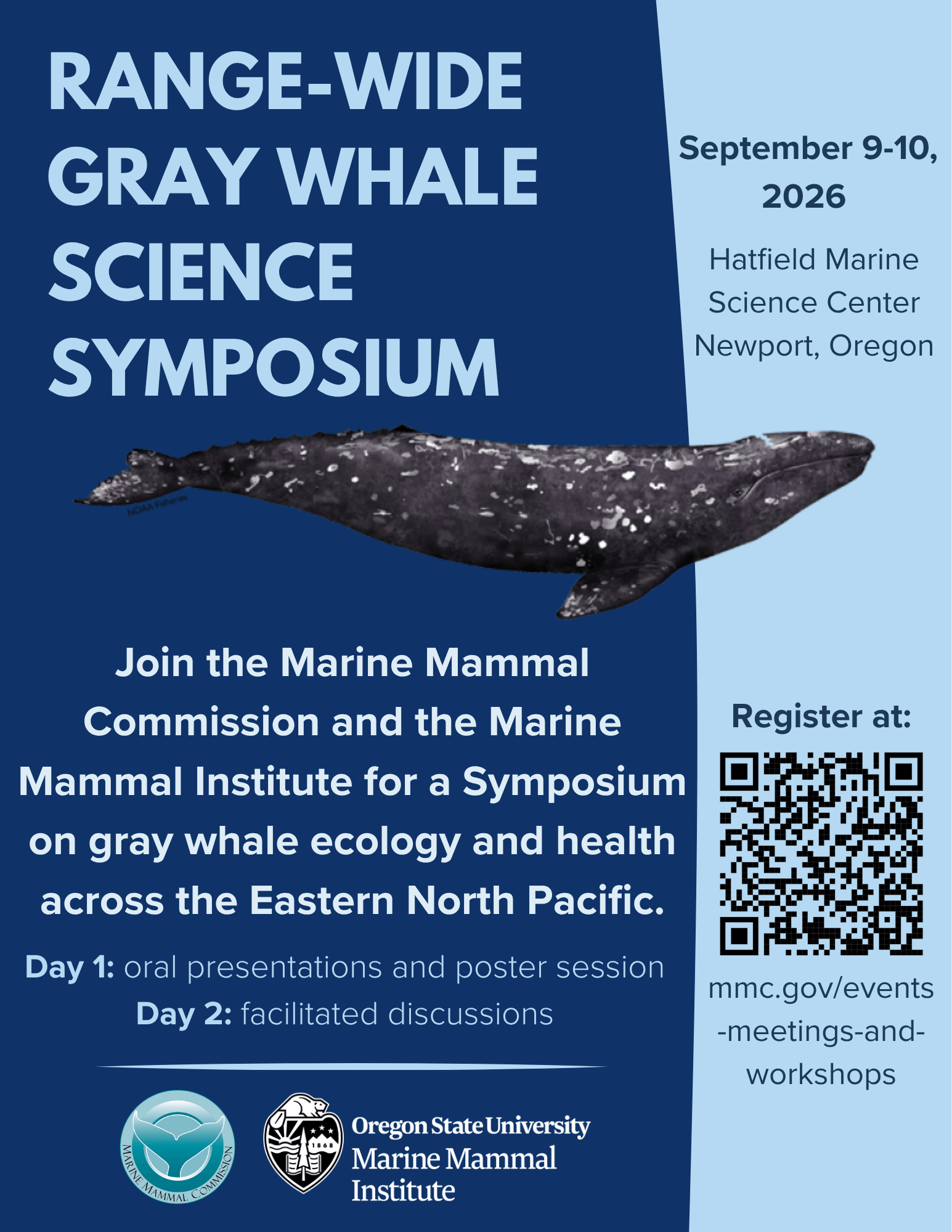
Experts from every part of the whales’ historic range, from Mexico to the Arctic, will discuss recent trends in health, feeding behavior, distribution and population dynamics. They will also try to identify priorities for future research, monitoring and coordination among both public and private groups studying gray whale health.
A public range-wide Gray Whale Science Symposium will take place on September 9–10, 2026, coordinated by the Marine Mammal Commission and hosted by the Marine Mammal Institute at Oregon State University in Newport, Oregon.
This two-day scientific meeting will focus on gray whale ecology and health across the Eastern North Pacific (ENP) and Arctic and will synthesize current research and observations to improve understanding of recent trends in health, feeding behavior, distribution, and population dynamics, and to identify priorities for future research, monitoring, and coordination.
The Symposium goals are to:
1) Review gray whale ecology and health status in the context of recent marine ecosystem variability in the ENP and Arctic;
2) Outline future priorities for gray whale ecology research and health surveillance and monitoring to help fill identified data gaps and address management objectives;
3) Enhance communication amongst scientists from Mexico, USA and Canada monitoring and conducting research on gray whale population status, health and ecology; and
4) Produce a workshop report summarizing presentations and recommendations for future directions.
Meeting Format
Day 1: Presentations and poster session
Invited oral presentations will provide a range-wide overview of gray whale status, trends, feeding ecology and health followed by an evening poster session highlighting additional research and observations. Day 1 oral presentations will be available both in person and remotely.
Day 2: Facilitated discussions and synthesis
Structured discussions will focus on key themes, knowledge gaps, and future priorities, with the goal of identifying areas for coordination and next steps.
Note: The Day 1 evening poster session and Day 2 discussions are in-person only.
Registration Register here! Registration is open to all interested participants. Note: IN-PERSON REGISTRATION IS FULL but you can still register to attend virtually or join the waitlist to attend in-person. https://www.mmc.gov/events-meetings-and-workshops/other-events/gray-whale-science-symposium/
Florence Chamber to Host Ambassador Conference
The Florence Area Chamber of Commerce will host the 2026 Oregon State Chamber Ambassador Conference October 1st through 3rd at Three Rivers Casino Resort. The annual event will bring Chamber Ambassador volunteers from communities across Oregon to Florence for leadership training, professional development, and networking. Chamber President and CEO Bettina Hannigan says the conference is an opportunity to showcase Florence as a destination for meetings and conventions while generating business for local hotels, restaurants, shops, and attractions. Organizers expect hundreds of attendees from throughout the state.
Reedsport Fire Department Seeks Volunteer Ham Radio Operators
The Reedsport Volunteer Fire Department is looking for volunteers interested in becoming licensed ham radio operators to support emergency communications in western Douglas County. Training is online and offered at no charge.
The Reedsport Volunteer Fire Department is looking for volunteers interested in becoming licensed ham radio operators to support emergency communications in western Douglas County.
The volunteers would work with the Western Douglas County Emergency Operations Center, located at the Reedsport Fire Station at 2680 Frontage Road.
According to the department, training is offered online at no charge. A background check is required for anyone interested in the volunteer positions.
Ham radio operators can play an important role during major emergencies, especially when normal communication systems are down. In those situations, radio operators may help keep local emergency officials connected with county, state and federal agencies.
The department said the positions are vital because ham radio could become one of the last available ways to communicate during an emergency incident.
Anyone interested in learning more can contact Melvina Adolf at 928-200-0979 or the Reedsport Fire Department at 541-271-2423.
Oregon Whale Sightings
Oregon Whale Sightings is a fun place to hear about and report cetaceans along our beautiful coastline.

https://www.facebook.com/groups/1176168644064352/
North Jetty Access Closed
Lane County has announced the long-term closure of North Jetty Road in Florence. The closure, which began Tuesday, May 26th, stretches from Harbor Vista Road to the entrance of North Jetty Park and is expected to continue through Friday, September 4th.
County officials say the closure is necessary as crews rebuild parking lots for North Jetty Park and the nearby dive park along North Jetty Road. There are no alternate vehicle routes available during the construction period, however access to the North Jetty beach can still be reached by the outlet near Driftwood Shores. Officials encourage visitors to plan ahead and avoid the area while work is underway.
Puffins on the Oregon Coast
Friends of Haystack Rock · We have puffins!
Check out our website, Friendsofhaystackrock.org to see them live! We have our webcam zoomed in on a couple active burrows. Your best chance to see them is in the morning between 8 a.m. and 11 a.m.

Organized by the Haystack Rock Awareness Program and Friends of Haystack Rock, the free event will not only celebrate the return of the puffins to their Oregon nesting grounds but also give the public the chance to spy on the birds as well. Interpretive rangers will be on hand with binoculars and spotting scopes to help people safely observe the tufted puffins.
Respect Nesting Areas to Protect Threatened Snowy Plover Mar. 15 through Sept. 15

The Oregon Parks and Recreation Department and Siuslaw National Forest remind visitors to the Oregon Coast that western snowy plover nesting season begins March 15 and runs through Sept. 15.
Beachgoers can help recovery efforts for the threatened shorebird by observing recreation restrictions at designated plover beaches.
Sensitive plover nesting areas are identified on maps for the northern Oregon Coast and southern Oregon Coast. Western snowy plovers nest in dry sand above the high tide line and are often difficult to see because they camouflage well.
To help protect these tiny shorebirds, please stay on wet sand and leave your dogs at home or at your campsite, even if they are leashed. Visitors may notice signs at trailheads with additional rules and limitations. There may be rope fencing in dry sand areas; this fencing delineates some, but not all, of the critical plover habitat that should be avoided.
Background on plover protections — Several land managers oversee beach activity for plover protection, primarily the U.S. Forest Service (USFS), the Bureau of Land Management (BLM) and Oregon Parks and Recreation Department (OPRD). For more information on how plovers are managed in Oregon, see the Habitat Conservation Plan (HCP): https://www.oregon.gov/oprd/PCB/Documents/WSP-HCP_08182010-web.pdf.

Donor Offers $50K Reward in 40-Year-Old Case of Missing Oregon Coast Teen

Lincoln County authorities hope the recent offer from an anonymous donor of a $50,000 reward will lead to the remains of a 17-year-old Siletz girl who was last seen walking on U.S. 20 more than four decades ago.
An anonymous donor put up money hoping it will spur information that leads not only to Kelly Disney’s remains but also to the conviction of her killer, according to the Lincoln County District Attorney’s Office.
The DA’s Office has confirmed that an anonymous donor offered the reward for any information leading to Disney’s remains and/or the conviction of her killer.
Information can be submitted anonymously at 541-265-0669 or online at FindKellyDisney@co.lincoln.or.us
READ MORE on CASE: https://lincolnchronicle.org/15597-2/
Wildlife Center of the North Coast · We need your help!
Make a difference in wildlife rescue! Join our Wild at Heart Membership Program starting at just $5/month. Help us save lives!  https://coastwildlife.org/wild-at-heart/
It’s been a busy summer here at the Wildlife Center of the North Coast, and our rehab clinic has gone through lots of supplies caring for patients!!

->> To help us restock and stay prepared for the next wave of wildlife in need, we’ve updated our Amazon Wishlist with the items we need most. https://www.amazon.com/hz/wishlist/ls/LU97SQA0VPZA
Every donation—big or small—goes directly to helping orphaned, injured, and sick wildlife get a second chance at life. Check out our wishlist here: https://www.amazon.com/hz/wishlist/ls/LU97SQA0VPZA Thank you for being part of our wildlife rescue family!
Volunteers are being sought to help prepare and serve lunch three times a week at the Florence Senior and Activity Center.
They serve lunch Monday, Wednesday, and Friday each week. Both programs, the in-house dining known as Cafe 60, and Meals on Wheels, are very important in helping promote socialization and nutrition for older adults in Lane County. Volunteer drivers for Meals on Wheels use their own vehicles, but they can be reimbursed for their mileage. The Lane Council of Governments operates the Senior and Disabled Services in Lane County. Alisa Andrion encourages potential volunteers to give her a call at L-COG, 541-682-1366.
Gleneden Beach Community Club Events
Look what’s coming up soon at the Club… (sign up at glenedenbeach.org)
Emergency Volunteer Corps of Nehalem Bay
Follow on Facebook: Emergency Volunteer Corps of Nehalem Bay
Oregon Food Bank · Find free food sites near you using OregonFoodFinder.org.
If you can’t make it to a food location, someone else can pick up food for you.You will just need to print and fill out the Authorized Representative form at https://lnkd.in/dsskUpkQ, and have them take it with them to the food sites. You can find step-by-step instructions at https://lnkd.in/dVBRxn-A.
Worried about recent changes or losing assistance?
Here are resources that can help:
211Info: Dial 2-1-1 or visit the211Info food webpagefor information and referrals to more than 1,500 food resources across Oregon.
Oregon Food Bank: Use the Oregon Food Bank’s Food Finder Mapto find over 100 food pantries, free food markets or hot meal programs near you.
Aging and Disability Resource Connection of Oregon (ADRC): Call 855-673-2372 or visit theADRC food webpage to find local meal programs and food boxes in your area.
Oregon Department of Human Services – Many Oregonians may qualify for SNAP work or activity rule exemptions without realizing it
Could you qualify for an exemption to SNAP work or activity rules? Contact us so we can talk about your situation and your options! Common reasons people might qualify include:- You’re pregnant.- You’re physically or mentally unable to work.- You’re already working enough hours to meet the requirement.- You’re participating in a qualifying education or training program.- You have moved to an exempt county or waived Tribal land.- You are responsible for caring for a child or another person, depending on their circumstances.
Learn more about exemptions in this news release: https://apps.oregon.gov/…/many-oregonians-may-qualify…Or visit https://oregon.gov/snapworkrules to find information about SNAP work rules and more.

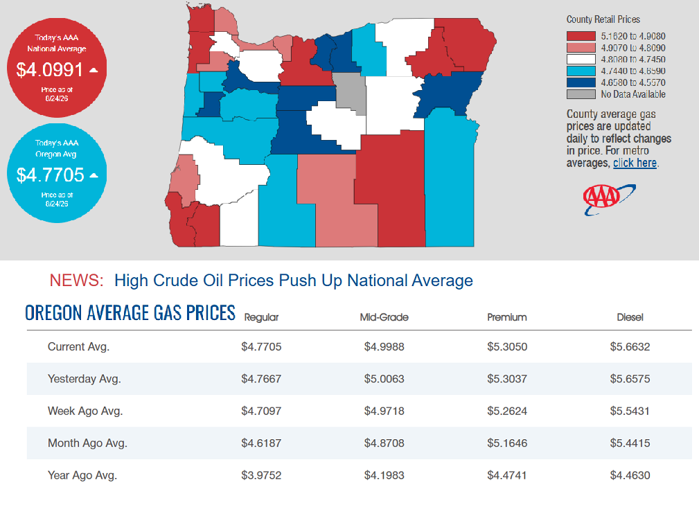
8/24/2026 — Gas Prices in Oregon Today

 PACIFIC NORTHWEST WILDFIRE UPDATE
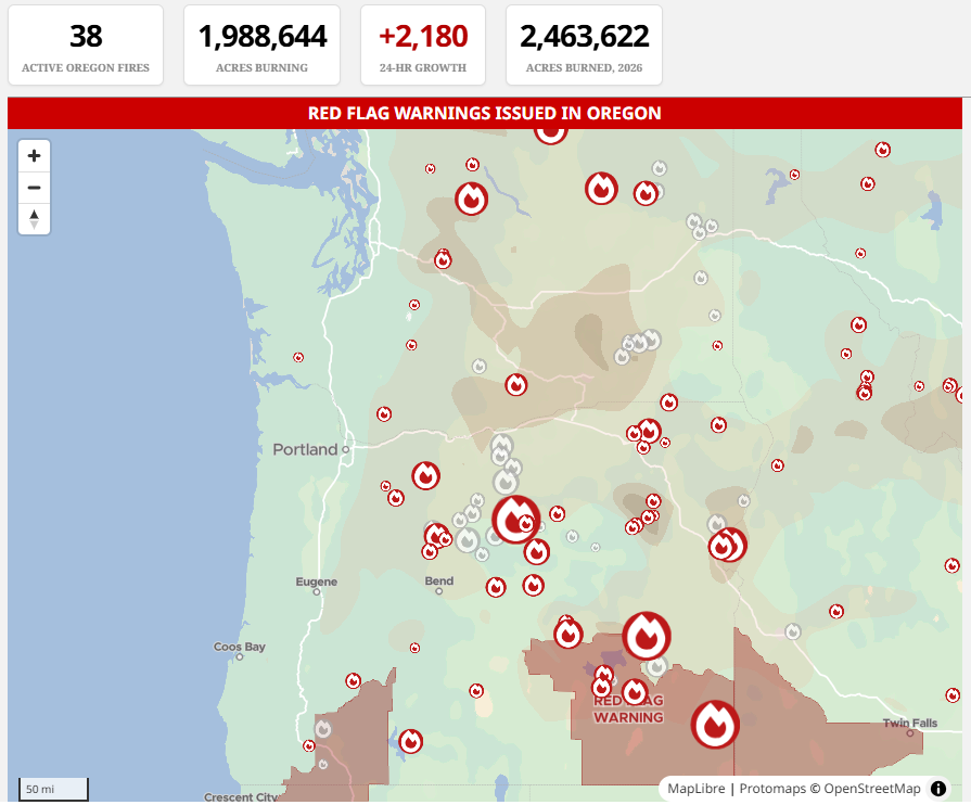
Oregon’s historic wildfire season continues to active battlegrounds across the state as of today, August 24, 2026. Over 2.4 million acres have burned this summer.
A brief dip in weekend temperatures helped fire crews achieve notable containment gains, but new lightning-caused fire starts near Bourne have triggered urgent evacuation orders in northeast Oregon.
New Fire Starts & Crucial Evacuation Updates:
- Bourne/Sumpter Area Fires (Baker County): Several new lightning-caused fires ignited just north of Sumpter over the weekend.
- Level 3 (“Go Now”): Enforced north of Mammoth Road/Forest Road 156, south of the Elkhorn Mountains crest, and west of Forest Road 160.
- Level 2 (“Be Set”): Enforced east of the Baker/Grant County line and north of Granite Hill Road. The Elkhorn Crest Trail is heavily impacted and should be entirely avoided.
- Wrights Spring Fire (Klamath County): Fire behavior is heavily fuel-driven near Saddle Mountain. Extreme fire conditions forced crews to temporarily pull back, keeping Level 1, 2, and 3 alerts active along Sprague River Road.
Major Ongoing Fire Containment Status
- Big Grass Fire: Burning across the Oregon-Idaho border, the state’s largest blaze sits at 575,132 acres. Favorable conditions have allowed crews to push containment to 93%, though blowing ash is causing highly reduced road visibility.
- Rowe Creek Complex: Holding steady at 373,981 acres and 89% contained as crews focus on deep mop-up operations.
- Grasshopper Fire: Now at 92,867 acres and 71% contained. Evacuation zones near the Mount Hood corridor have dropped to a Level 1 “Be Ready,” though Level 3 “Go Now” orders remain within the Badger Creek Wilderness area.
- Hagen Fire: Located across Umatilla and Union counties, this incident is still a high concern at 57,000 acres and only 19% contained. High winds continue to drive the fire along its eastern side.
- Central Oregon Blazes: The Shingle Fire (93% contained), Bench Fire (90% contained), and Coyote Fire (94% contained) have successfully stabilized over the last 48 hours.
Air Quality & RestrictionsAir quality remains highly impacted with reduced visibility across much of central and eastern Oregon due to lingering smoke. Active public use restrictions and public land closures remain heavily enforced by the U.S. Forest Service Alerts and the Bureau of Land Management. You can view highly localized, real-time smoke conditions via the AirNow Fire and Smoke Map.
Air Quality Alerts – Smoke from these massive blazes continues to blanket much of central and eastern Oregon. You can monitor your highly localized breathing conditions and smoke forecasts using the official AirNow Fire and Smoke Map.
For real-time evacuation zones, check the local county sheriff’s pages, monitor highway updates via TripCheck, or view the interactive tracking tools via The Oregonian Wildfire Tracker.
🗺️ Critical Resources for Evacuations & Travel — Because fire behavior, road closures, and air quality fluctuate rapidly, residents should utilize official tracking platforms before traveling:
- Evacuation Maps: Check real-time statuses using Oregon’s RAPTOR tracking map or local county sheriff’s pages.
- Road Closures: View live traffic adjustments and highway conditions on TripCheck.
- Smoke Updates: Track local pollution and breathing safety recommendations via the Oregon Smoke Information Blog.
New Oregon survey for businesses facing wildfire losses could inform disaster assistance
Oregon officials are urging business owners who have closed their businesses, seen reduced customers and revenue or discovered physical damage due to ongoing wildfires to help inform future federal financial assistance efforts through a new survey.

(Photo courtesy of Oregon Department of Forestry)
The Oregon Department of Emergency Management announced the survey in a recent press release for businesses experiencing physical damage or economic losses from wildfires or wildfire smoke. State officials can use the information to make a stronger case for additional disaster funding, according to the agency.
Completing the survey doesn’t guarantee assistance, but the findings will document economic impacts to businesses and “help determine” whether areas of the state qualify for the U.S. Small Business Administration’s Economic Injury Disaster Loans.
The federal program offers funds to ensure businesses can continue offering health care benefits, pay rent and utilities and make debt payments, and businesses have a year to start repaying the loans, according to the federal agency’s website. Qualifying organizations must face “substantial economic injury” and include most private nonprofits, small agricultural cooperatives, and small businesses.
“As wildfires and prolonged smoke affect communities across Oregon, impacts can extend well beyond areas directly touched by fire,” state emergency officials said in the press release. “Businesses may experience physical damage, closures, reduced customers, canceled events or activities, lost revenue, or other disruptions associated with wildfire and smoke conditions.”
The federal government has offered such assistance in Oregon before. The U.S. Small Business Administration in June announced that it would offer the loans to Oregon businesses, nonprofits and residents affected by straight-line winds, flooding, severe storms, landslides and mudslides during December. That assistance also included physical disaster loans for up to $2 million and came in response to a request for assistance from Oregon Gov. Tina Kotek days earlier. (SOURCE) Oregonians interested in completing the survey can visit this link for the survey in English, and this link for the survey in Spanish.
Unauthorized Drone Flights Over Wildfires Can Ground Life-Saving Aerial Operations

A joint statement from the Oregon Department of Aviation and the Oregon Department of Emergency Management
The Oregon Department of Aviation (ODAV) and the Oregon Department of Emergency Management (OEM) are jointly urging all drone operators to follow federal and state regulations: Do NOT fly drones over or near active wildfire areas under any circumstances. If you fly, we can’t.
Across Oregon and the nation, unauthorized drones have repeatedly forced wildfire managers to ground firefighting aircraft. When a drone is spotted in a fire zone, air crews must halt operations until the drone is cleared. These interruptions allow wildfires to intensify and spread, increasing risks for firefighters, nearby communities, and critical infrastructure.
Why Drone Interference Is So Dangerous
- Firefighting aircraft operate at very low altitudes, often in the same airspace used by recreational drones, creating significant collision hazards.
- Even brief disruptions can halt suppression operations at critical moments.
- In Oregon, recent incidents have already delayed aircraft responding to active wildfires, hindering containment efforts and putting crews at greater risk.
Drone detection equipment may be deployed at or near active wildfire incidents to help identify unauthorized drone activity and protect the airspace needed for firefighting operations.
Legal Consequences for Unauthorized Drone Flights
ODAV and OEM emphasize that penalties for flying a drone near a wildfire are substantial:
- Up to $75,000 in civil fines
- Up to 12 months in federal prison
- Confiscation of drone equipment
- Permanent revocation of pilot certificates
These penalties reflect the seriousness of interfering with emergency aviation operations.
What Drone Operators Must Do
- Check Temporary Flight Restrictions (TFRs) before operating any drone.
- All active wildfire areas are strict No Drone Zones. This includes at night and on the weekends.
- Keep emergency airspace clear to ensure firefighters can work safely and effectively.
- Report unauthorized drones immediately to local law enforcement or call 9‑1‑1.
Statements from Officials
“No photo is worth a federal prison sentence or a $75,000 fine. When your drone is in the air, fire aircraft can’t fly, delaying critical firefighting efforts. Don’t fly drones over wildfires, day or night – EVER ” the Oregon Department of Emergency Management, Director of Response and Recovery, Andrew Jahier, said.
“Flying a drone near a wildfire can put lives at risk. Firefighting aircraft operate in extremely challenging conditions, and an unauthorized drone can force those aircraft out of the area when they are needed most. We need every drone owner to understand the responsibility that comes with flying. If there is a wildfire nearby, keep your drone on the ground and give firefighters the airspace they need to protect our communities,” the Oregon Department of Aviation Director Kenji Sugahara, said.
ODAV & OEM Encourage Oregonians to Help Protect Their Communities
Both agencies are working with state, federal, and local partners to ensure safe airspace during Oregon’s increasingly active fire seasons. Keeping drones grounded near wildfires is one of the most important ways Oregonians can contribute to community safety.
For more guidance on safe and responsible drone use, visit the Oregon Department of Aviation at oregon.gov/aviation and follow ODAV (@ORAviation) and OEM (@oregonOEM) on most social media platforms.Media line: 503-934-3310 or OEM_PublicInfo@oem.oregon.gov
It is the mission of the Oregon Department of Emergency Management (OEM) to lead collaborative, statewide efforts to support Oregon’s communities before, during and after emergencies, with a vision to create a ready and resilient Oregon. OEM prioritizes an equitable and inclusive culture of preparedness that empowers all Oregonians to thrive in times in crisis. For more information about OEM, visit oregon.gov/oem. You can get this document in other languages, large print, braille, or a format you prefer. For assistance, email OEM_PublicInfo@oem.oregon.gov. We accept all relay calls, or you can dial 711.
Wrights Spring Fire Update August 24, 2026
Website: https://inciweb.wildfire.gov/inciden…/orfwf-wrights-springEmail: 2026.wrightsspring@firenet.gov Phone: 541-712-4438Social Media, Evacuation and Closure Information: https://linktr.ee/2026.wrightsspring Smoke Outlook: https://outlooks.wildlandfiresmoke.net/outlook/6c74f4c6
The Wrights Spring Fire in Klamath County, Oregon, has burned 53,061 acres and is 55% contained as of today, August 24, 2026. Firefighters have successfully established a containment line around the entire perimeter of the fire. Favorable weekend weather—including lower temperatures, higher humidity, and calmer winds—has significantly aided suppression efforts.
The Klamath County Sheriff’s Office continues to closely monitor conditions and manage the remaining impact zones. Current Status & Operations:
- Command structure: Northwest Complex Incident Management Team 8 remains in full command of the incident.
- Active zones: Firefighters are actively patrolling for hotspots and securing boundaries, particularly near Swan Lake Point where elevated fire activity and visual glow were reported.
- Infrastructure protection: Crews continue to monitor utility lines and secure areas near Bliss Road, Flat Lake, Saddle Mountain, and Swan Lake Rim.
Evacuations and Closures
- Evacuation downgrades: Due to improved conditions, the Klamath County Sheriff’s Office downgraded evacuation levels across multiple sectors. A majority of the livestock and animals sheltered at the Klamath County Fairgrounds have begun returning home.
- Road updates: Sprague River Road has officially reopened to traffic. However, Bliss Road and local fire-damaged secondary roads remain restricted to residents and emergency personnel only.
- Forest closures: Emergency public use closures remain active across the affected portions of the Fremont-Winema National Forest.
Areas around Wrights Spring Fire are experiencing high volumes of fire traffic and ongoing suppression activity. Firefighter safety remains the top priority and the public is asked to avoid unnecessary travel to prevent congesting traffic. Forest Closures: The Fremont-Winema National Forest issued an Emergency Closure Order on August 09, 2026. https://www.fs.usda.gov/…/fire-area-emergency-closure
No Fly Zone: A Temporary Flight Restriction (TFR) over the area remains in effect. Flying drones near the fire is prohibited and can interfere with firefighting aircraft, potentially grounding aerial suppression operations. http://knowbeforeyoufly.org.
DONATIONS NEEDED FOR FIRE VICTIMS – The Klamath County Chamber of Commerce is asking the public for animal supplies and gas cards as the Klamath County Event Center and Fairgrounds houses 713 animals.
Grass hay, dog food, cat food, chicken feed and pig feed are some of the supplies being asked for as more animals are expected to arrive. Small food and water bowls, no matter the size, are also encouraged. Donations don’t need to be brand new and all donations will find a purpose.
Equipment like bungee cords and stackable wire cages are being asked for by the community for cages and security for animals. Gas cards are also being sought after as community members have been using their own vehicles and money toward assisting with animal evacuations and helping others.
As for food, donate to the Klamath Lake Food Bank. As for animal donations, the Chamber of Commerce asks those donating to enter the Klamath County Fairgrounds through Gate 3 on the Senior Center side. Donations will be available from 7 a.m. to 9 p.m. Gas card donations can be made at Ezell Suty Fuel, 2360 S. 6th Street.
Evacuations for people in need, are located at Chiloquin Elementary and Living Springs Church in Bonanza.
The Klamath Karavan is stepping up to help families affected by the Wright Spring Fire, and they need your help! Donations of bottled water, Powerade, Gatorade, light jackets, sweaters, socks, pet food—and lots of prayers are greatly appreciated. You can drop off donations at Starvn Marvn’s, 1822 Austin Street in Klamath Falls. Every donation, big or small, can make a difference for our neighbors who are going through a difficult time.
Voters in Oregon will have the opportunity to weigh in on a statewide initiative aimed at enhancing controlled burns to mitigate wildfire risks.
The proposed Oregon Controlled Burn and Wildfire Prevention Act mandates the Oregon Department of Forestry to create and oversee a comprehensive controlled burn program. This initiative seeks to prevent catastrophic wildfires by safely incinerating hazardous vegetation before it can contribute to larger blazes.
The department will assess both public and private lands to determine their suitability for controlled burns, prioritizing areas that are at high risk for wildfires and regions where forests are in close proximity to communities. Controlled burns, as defined by the initiative, are carefully planned fires conducted by trained professionals under specific weather and fuel conditions.
These measures are intended to diminish hazardous vegetation, enhance ecosystem health, and safeguard local communities.
Statewide hotline available for Oregonians affected by wildfires and smoke
People anywhere in Oregon who have been affected by wildfires or wildfire-related air quality can call 1-833-699-0554 24 hours a day, seven days a week.

The statewide hotline is available to people experiencing any wildfire-related impact, including those who:
- Lost a home or property
- Evacuated and have ongoing needs
- Are sheltering in place and have wildfire-related needs
- Are affected by wildfire smoke or poor air quality
- Have another need or concern caused by a wildfire
“During this difficult wildfire season, Oregonians impacted by fires deserve immediate and reliable access to the help they need,” said Governor Tina Kotek. “That’s why we’ve established a dedicated, 24/7 hotline – so that no Oregonian has to navigate this wildfire season alone or wonder where to turn to for help.”
The hotline is staffed by 211info. If a call is not answered, callers can leave a message and will receive a return call within one business day.
This hotline does not provide emergency evacuation assistance or help people locate immediate shelter. People who are in immediate danger, have a medical emergency, or need emergency help evacuating should call 911. People looking for information about shelters or other immediate resources can call 2-1-1. For current 211info operating hours, visit 211info.org.
People can also enter their contact information and describe their wildfire-related needs using the Oregon Wildfire Assistance web form. An ODHS staff member will review the information and follow up with them.
“This wildfire season is already affecting a growing number of Oregon Tribes and communities,” said Ed Flick, Director, ODHS Office of Resilience and Emergency Management. “Wildfires can affect people in many ways, even when their homes have not burned. We want people to know there is one place they can call to share what they are experiencing and learn what resources may be available.”
In previous years the hotline has been used to connect people who lost homes in disasters with recovery support. This year, the Oregon Department of Human Services is expanding it to people experiencing a broader range of wildfire impacts.
ODHS has informally coordinated individual assistance following Oregon disasters since 2020. This year, Governor Tina Kotek directed ODHS to be ready to formally activate individual assistance when needed as the state prepares to establish a formal program in 2027 under House Bill 4121.
211info and ODHS will work with local communities to connect people with existing programs and local resources. If those resources are not enough to meet the level of need, ODHS will work with state leaders to identify additional support and funding options.
The hotline does not guarantee financial assistance or eligibility for a particular program. Staff will listen to each caller’s experience, document their needs and help identify available resources and next steps.
Hotline information
- Call: 1-833-699-0554
- Available: 24 hours a day, seven days a week
- Missed calls: Leave a message and your call will be returned within one business day
- Shelter and other immediate resource questions: call 211
- Emergencies or emergency evacuation help: call 911
New survey asks Oregonians how they want transportation dollars spent
The group tasked with developing recommendations on how to maintain Oregon’s transportation system wants to hear from Oregonians about what they think the state’s transportation priorities should be in a new survey. Oregonians can take the survey online at https://www.cognitoforms.com/ODOT2/ROTVSurvey.

The Oregon Department of Transportation is facing a $200 million budget shortfall in the 2027-29 budget cycle. The gap marks the fifth budget cycle in a row where the agency will have to cut services and staff unless the Oregon Legislature finds a way to provide additional revenue. The agency’s budget shortfall stems from the rising cost of materials and labor, as well as flattening gas tax revenue as more people drive fuel-efficient and electric vehicles.
After spearheading several unsuccessful attempts at finding new revenue for the state’s massive transportation agency, Gov. Tina Kotek convened 12 transportation and business experts to participate in a workgroup to help come up with solutions to the agency’s budget gap. The group has until the end of the year to deliver funding recommendations to Kotek, though lawmakers asked to receive recommendations earlier.
The survey asks Oregonians their top six transportation priorities, how they think the agency should spend its limited funding and what reductions would impact them the most.
Oregonians have until 6 p.m. Sept. 10 to complete the survey. Oregonians can also send their feedback to the workgroup’s email at rebuildingtransportation@odot.oregon.gov. — (SOURCE)
A suspect in the killings of five people outside Forest Grove was found dead in Washington, authorities said. Investigators identified him as Benjamin Parker, 36.
Suspect in killings of 5 people near Forest Grove found dead in Washington state
A suspect in the killings of five people outside Forest Grove was found dead inside a vehicle in Enumclaw, Washington, authorities said Sunday evening.
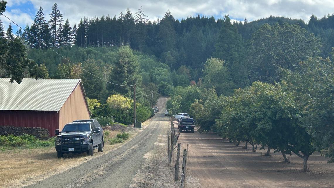
The suspect, identified as 36-year-old Benjamin Charles Parker, died by an apparent suicide, Washington County Sheriff Caprice Massey said.
Detectives identified Parker as a suspect in the case and determined he was in Enumclaw, about 50 miles southeast of Seattle. Officers with the Enumclaw Police Department found Parker’s vehicle behind a Safeway store and discovered him dead inside.
Investigators do not believe there is a threat to the public, Massey said. “We do not believe there’s a risk to the community,” Massey said. “This was our suspect and he died in Enumclaw, Washington.”
Investigators also have not released details about how they connected Parker to the crime scene. Five people and multiple domesticated animals were found dead in a rural area outside Forest Grove after authorities responded to a vehicle fire early Saturday morning.
Washington County Detective Shannon Wilde said Sunday afternoon that the case is being investigated as a “quintuple homicide” and that investigators are treating the five deaths as murders. Investigators do not believe the killings were random.
Sheriff Caprice Massey described the case as a complex investigation involving a large scene and numerous law enforcement agencies. “In my 22 years here, I have not been a part of or witnessed a scene quite this complex involving this type of an investigation,” Massey said. “I recognize that this incident is deeply concerning to our community. Our investigators are working to determine what happened, and we have dedicated every available resource to this case.”
Deputies were called at about 5:27 a.m. Saturday to assist the Forest Grove Fire & Rescue, which was responding to a vehicle fire at 47350 Northwest Otis Lane outside of Forest Grove, near Hillside Road. Firefighters discovered human remains and called law enforcement. Investigators later determined that five people and multiple domesticated animals had died.
The identities of the five people had not been released Sunday evening. Massey said investigators are still working to identify the victims and notify their families before releasing their names. Authorities also have not confirmed whether the victims lived at the property. Investigators said there was information indicating Parker may have been connected to the property, but they were still working to confirm those details.
Investigators have not released details about the crime scene, including whether the victims were found together or separately, where the bodies were located or when the deaths occurred.
Authorities also would not provide more details about the vehicle fire, including what was burning or the extent of the fire.
Wilde said authorities waited more than 24 hours to provide additional information because they wanted to ensure they had accurate information to release while also working to identify the victims and notify their next of kin.
Authorities said they are not aware of any additional victims at this time. The incident caught the attention of Oregon governor Tina Kotek. In a statement on social media, the governor said in part, “Whatever the circumstances, let’s keep the family and friends of the victims in our hearts and prayers.”
The sheriff said investigators want to talk to anyone who has information about the residence or the people who live there. “There are no details too small,” Massey said.
Anyone with information can contact the WCSO non-emergency line at 503-629-0111 and reference case No. 50-26-11866. (SOURCE)
The Trump administration has moved to rescind protections for nearly 2 million acres in Oregon, potentially opening them up to development.
The U.S. Forest Service on Tuesday filed a proposal that would overturn the two-decade old “roadless rule” that protects iconic forests and recreation spots in national forests in ten Western states. The 2001 rule prohibits road construction, road upgrades and timber harvesting.
Officials say repealing the rule is needed to spur economic growth and improve forests’ wildfire resilience. Environmental groups counter that opening the protected acres to development will hurt outdoor recreation, drinking water supplies, fish and wildlife habitat and carbon storage.
Trump administration advances plan to rescind protections for nearly 45 million wild acres
The USDA decision to rescind the 25-year-old forest and wildland protections was made without officials hosting any public meetings

The Trump administration will move ahead with plans to end more than 25 years of sweeping protections for tens of millions of wild, federally managed acres across the U.S.
Brooke Rollins, head of the U.S. Department of Agriculture, on Tuesday filed a rule to rescind “in its entirety” the national 2001 Roadless Area Conservation Rule, which prohibits road construction, logging and mining on about 30% of lands managed by the U.S. Forest Service, mostly in forested areas of the West. Rollins had last year filed a notice of intent that the agency was considering “rolling back” some protections under the rule.
A draft environmental impact statement will be posted Wednesday, and the public will have until 11:59 p.m. Eastern time/8:59 p.m. Pacific time on Sept. 21 to comment before changes are finalized. Comment on the Roadless Rule termination and environmental impact statement here.
The Roadless Rule prohibitions are intended to protect wildlife, watersheds and old-growth forests from human development and human-caused wildfires. But in her announcement, Rollins said she was rescinding the rules on nearly 45 million acres under the banner of wildfire prevention, saying the protections instead have led to “overgrown stands, insect outbreaks and disease” turning “healthy landscapes into tinderboxes.”
“For too long, outdated restrictions have kept tens of millions of forested acres off-limits to the very treatments that improve forest health and reduce wildfire risk to our communities,” she said.
Rollins’ assertions are not borne out by research, including from Oregon State University Professor Chris Dunn, a forest ecologist and wildfire expert. Dunn and his colleagues found that most wildfires in Western national forests between 1984 and 2018 started near roads, showing an increased likelihood of wildfires where roads exist because the No. 1 cause of wildfires is people.
The U.S. Forest Service’s own research also shows the majority of human-caused ignitions occur on roadsides, and 20 years of monitoring data does not support assertions that repealing road prohibitions will improve forest health, researchers found.
No public meetings – Rollins first proposed rolling back the rule in August 2025, saying at the time the move would support President Donald Trump’s executive orders meant to increase logging and energy development on federal lands.
That notice of intent set off a 21-day public comment period that brought in more than 600,000 comments, most of which expressed opposition to any changes that would erode the Roadless Rules prohibitions on development. Federal officials have not held a single public meeting since then.
In the two years leading up to final passage of the 2001 rule, Forest Service officials held 600 public meetings across Western states and received more than 1.6 million public comments.
Roughly 96% of the Forest Service’s inventoried roadless areas are located in 12 western states, including 2 million acres in Oregon within places like Iron Mountain in the Willamette National Forest, Joseph Canyon in Wallowa County, Tumalo Mountain in central Oregon and Lookout Mountain in the Ochoco National Forest.
Last year, U.S. Rep. Andrea Salinas, a Democrat representing Oregon’s 6th Congressional District based in the Willamette Valley, introduced the Roadless Area Conservation Act to enshrine the rule in federal law, but it does not yet have enough support to pass. In the House, 88 of her Democratic colleagues have signed on as co-sponsors, including Oregon Reps. Suzanne Bonamici, Janelle Bynum and Maxine Dexter, as have 25 U.S. senators. The state’s two other representatives, Democrat Val Hoyle and Republican Cliff Bentz, have not signed on as sponsors.
No state would be more affected by the rule termination than Alaska, which has almost a third of the 45 million acres affected by the pending change.
Alaska is home to the Tongass National Forest, a West Virginia-sized stretch of islands and waterways in the Southeast Alaska panhandle that make up the largest surviving temperate rainforest in the world.
Idaho and Colorado would not be impacted by the rule changes because the two states negotiated their own agreements with the federal government more than a decade ago to permit projects that would “reduce hazardous fuels” near wildfire prone communities and to allow some local and state decisions about development on the federal acres.
Different takes on the past 25 years – U.S. Forest Service Chief Tom Schultz, who previously worked for one of the country’s largest lumber producers in Idaho, said in a statement last year that the Roadless Rule has frustrated land managers for years and served as a barrier to commercial logging.
“More than 40% of inventoried roadless areas, primarily in the West, have high or very high wildfire hazard potential. And only 5% of those areas have received hazardous fuels reduction treatments since 2014,” he said.
Rollins’ announcement included praise from the Republican governors of Montana, Utah and Wyoming, who said rescinding the federal protections would give their states flexibility to manage land locally. Democratic governors and other elected officials in states including Oregon, Washington and New Mexico have criticized the administration’s efforts and blame a century of largely unrestricted logging on federal lands, climate change and recent losses to Forest Service staff for worsening fires and declining forest conditions in the West.
Statements following Rollins’ announcement made clear conservation and logging groups have seen the last 25 years of the Roadless Rule quite differently.
Abigail Dillen, president of the nonprofit environmental legal group Earthjustice, said in a statement that the group will likely sue to stop the rule changes from moving forward.
“For 25 years, the Roadless Rule has kept our wildest forests intact. The benefits have been incalculable for people, for water, for wildlife, and for the climate,” she said. “Earthjustice has successfully defended the Roadless Rule for a quarter century, and we are not going to stop now.”
Travis Joseph, president of the American Forest Resource Council, a trade association representing the timber industry, said in a statement that the Roadless Rule is among “failed policies” meant to protect forests.
“The Forest Service is right to take a hard look at a policy that was written for forest conditions that looked very different 25 years ago,” he said. “Our national forests are experiencing severe wildfire, drought, insects and disease on a scale that few anticipated when the Roadless Rule was adopted.” https://oregoncapitalchronicle.com/2026/08/18/trump-administration-advances-plan-to-rescind-protections-for-nearly-45-million-wild-acres/
Oregon’s Nonfarm Payroll Employment Drops by 4,100 in July
In July, Oregon’s seasonally adjusted nonfarm payroll employment declined by 4,100 jobs, following a revised gain of 1,300 jobs in June. July’s losses were largest in professional and business services (-1,800 jobs), leisure and hospitality (-900), and government (-700). Gains were largest in retail trade (+500 jobs).
In the past 12 months, professional and business services was on a slightly downward trend, declining by 2,500 jobs, or 1.0%. Most of the decline was in management of companies and enterprises, which cut 2,200 jobs, or 4.6%, in that time. The other two component industries saw little change during that period: professional and technical services (+200 jobs, or 0.2%) and administrative and waste services (-500 jobs, or -0.5%).
Leisure and hospitality employed 203,800 in July, which was 3,500 jobs below its average of 207,300 from 2023 through 2025. It cut 3,800 jobs since January, following a very flat trend during the prior three years. Despite recent weakness, its component industry arts, entertainment, and recreation added 200 jobs in July to reach a record high of 31,300.
Oregon’s government sector lost 4,500 jobs, or -1.4%, since July 2025. All components cut since July 2025. Federal government dropped 1,600 jobs, or -5.7%; state government lost 200 jobs, or -0.4%; and local government job counts declined by 2,700, or -1.1%.
Retail trade added 500 jobs in July, but that follows a consistent long-term trend of job declines during the past four years. It employed 198,000 in July, which was a drop of 12,700 jobs, or 6.0%, since July 2022.
Oregon’s unemployment rate was 5.2% in July. It has been 5.2% each month since January. The U.S. unemployment rate was 4.2% in June and 4.1% in July.
About Workforce and Economic Research
The Workforce and Economic Research Division of the Oregon Employment Department develops and distributes quality economic and workforce information to help Oregonians make informed decisions and support a thriving economy. Staff collect data from state and federal records and surveys; analyze the available information; and share insights with the public in a variety of ways, including regular reports, publications, and the website, QualityInfo.org.
The Oregon Employment Department (OED) is an equal opportunity agency. OED provides free help so you can use our services. Some examples are sign language and spoken language interpreters, written materials in other languages, large print, audio, and other formats. To get help, please call 503-947-1444. TTY users call 711. You can also send an email to communications@employ.oregon.gov.
El Departamento de Empleo de Oregon (OED) es una agencia de igualdad de oportunidades. El OED proporciona ayuda gratuita para que usted pueda utilizar nuestros servicios. Algunos ejemplos son intérpretes de lengua de señas e idiomas hablados, materiales escritos en otros idiomas, letra grande, audio y otros formatos. Para obtener ayuda, por favor llame al 503-947-1444. Usuarios de TTY pueden llamar al 711. También puede enviar un correo electrónico a communications@employ.oregon.gov.
Klamath County Aircraft Crash

On Thursday, August 20, 2026, at approximately 9:13 a.m., Klamath County Sheriff’s Office deputies and fire personnel were dispatched to the area of Hill Road and Crystal Springs Road following a report of an aircraft crash.
Preliminary information indicates a single-engine, fixed-wing aircraft, piloted by Gus Macy, was conducting an agricultural pesticide application flight when the aircraft appears to have struck a Basin Mediactive Radio tower.
The aircraft subsequently crashed to the ground and caught fire. A witness who was nearby immediately responded to the crash site and was able to pull Macy away from the burning wreckage before emergency personnel arrived.
Macy sustained major injuries and was transported to Sky Lakes Medical Center for treatment. The circumstances surrounding the crash remain under investigation. Additional information will be released as it becomes available and appropriate.
Detectives Investigating Death of Rural Central Point 2-year-old Child
Video Brief available for download: https://vimeo.com/1219641823?share=copy&fl=sv&fe=ci
JCSO 26-4291 — CENTRAL POINT, Ore. – Jackson County Sheriff’s Office (JCSO) Criminal Investigations Division (CID) detectives are investigating the death of a 2-year-old child in rural Central Point. Major Assault and Death Investigation Unit (MADIU) detectives responded to assist.

At 4:30 AM, ECSO dispatch received a call for a missing child in the 9900 block of Blackwell Road in rural Central Point. JCSO deputies and Oregon State Police (OSP) troopers arrived on scene and immediately began searching for the child. At 5:41 AM the child was located deceased. Detectives are currently investigating the circumstances surrounding the child’s death.
MADIU consists of detectives from JCSO CID, OSP, Medford Police Department, Central Point Police Department, Ashland Police Department, and the Jackson County District Attorney’s Office.
This case is open and ongoing with detectives following additional leads. There is no further information available for release at this time.
Oregon is now the seventh-most expensive state in the nation, with a single adult needing a pre-tax income of $110,074 to live comfortably. According to the SmartAsset 2026 Study
A recent study by financial technology firm SmartAsset reveals that a single adult in Oregon now requires an income of $110,074 to live comfortably, reflecting a 5.2% increase from the previous year. For a family of four, the necessary income rises to nearly $281,000.
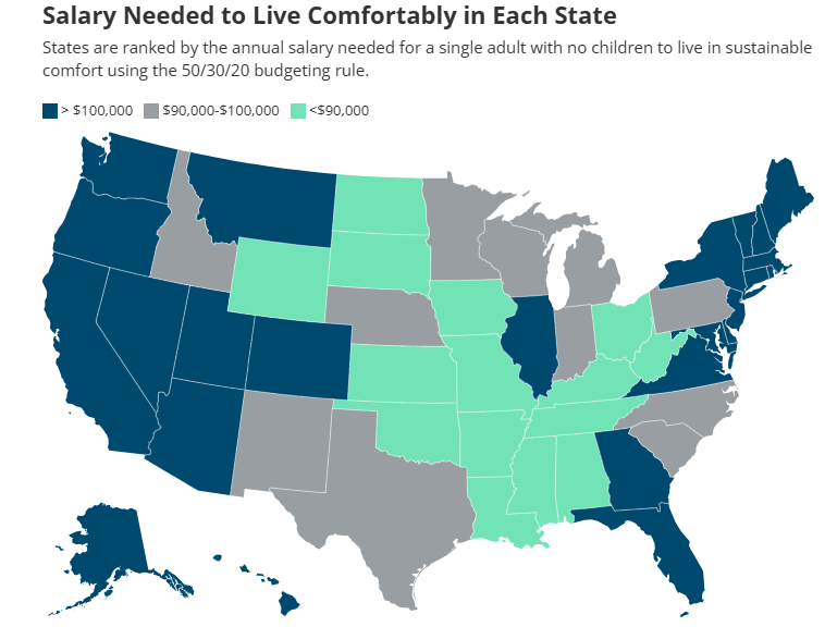
This positions Oregon as the seventh-most expensive state in the country for individuals seeking a comfortable lifestyle. The study employs a 50-30-20 budgeting framework, allocating half of the income to essential needs, 30% to discretionary spending, and 20% to savings or debt repayment. Comparatively, the income threshold for comfort
varies significantly across the nation, ranging from approximately $81,000 in West Virginia to $129,000 in Hawaii. https://smartasset.com/data-studies/heres-the-salary-it-takes-to-live-comfortably-in-each-u-s-state-in-2026
L. L. Stub Stewart and Rooster Rock State Parks will host OMSI Star Parties this summer

— L.L. Stub Stewart and Rooster Rock State Parks will celebrate the night sky with free stargazing parties in July, August and September.
The parks are partnering with OMSI and Rose City Astronomers to host an OMSI Star Party 2026, which includes a presentation at dusk and stargazing from 9 to 11 p.m. Telescopes will be provided by volunteers, and visitors are welcome to bring their own. Depending on the weather, stargazers will search out stars, the moon, and planets.
“We love helping people experience the park in a different way. After dark, everything feels calmer, quieter, and a little more magical,” shared Park Ranger Jeremy Williams at L. L. Stub Stewart State Park.
These events are free. Parking in the day-use areas requires a $10 parking permit per vehicle or you can use an annual parking pass if you have one.
Visitors are encouraged to bring their own chairs, blankets, warm clothing, snacks and water. Bug repellent is always a good idea. Please use red flashlights to avoid interfering with the dark sky viewing. You can also cover your flashlight or smartphone with red electrical tape.
Star maps will be provided along with recommended astronomy apps that visitors can load on their phones if interested.
Visitors should arrive early to familiarize themselves with the area and park only in designated spaces. Overnight camping is not permitted in day-use areas, though campground reservations are available at stateparks.oregon.gov.
On the scheduled day for OMSI Star Parties, visitors should visit the OMSI website for possible weather-related cancellations. The long-range forecast looks promising for excellent viewing.
“Whether you come to Rooster Rock to count Perseids or simply to spend a peaceful evening under the stars, the meteor shower is a wonderful excuse to slow down, look up, and experience the Gorge in a whole new light”, said Park Ranger Elika Paki at Rooster Rock. “And if you lose track of how many shooting stars you’ve seen, don’t worry, that just means you’re doing it right.”
All events begin at dusk. We recommend arriving early to accommodate parking. Parks will close at 11:45 p.m.
Equinox Celebration | Saturday, September 12 at L. L. Stub Stewart State Park
You can find additional details about the event, parking logistics, whether pets are allowed, and how to request accessibility accommodations on the L.L. Stub Stewart State Park and Rooster Rock State Park event pages, and the OMSI event page.
Oregon State Parks often hosts stargazing events across the state. More opportunities can be found on Oregon State Parks’ event page.
High Desert Museum · Congratulations to Alexa Hagerty, winner of the 12th annual Waterston Desert Writing Prize!

 Alexa, a writer and anthropologist, was recognized for “Salt, Cloud, Ghost: A Journey through Desert, Deep Time, and Digital Age,” a journey through Chile’s Atacama Desert where the extraction of minerals and data for AI meets the region’s long history of colonialism, dictatorship and disappearance.
She’s also the author of “Still Life with Bones: Genocide, Forensics, and What Remains,” a New York Times Editors’ Choice, one of the New Yorker Best Books of the Year, and winner of the 2024 Juan E. Méndez Book Award for Human Rights in Latin America.
Join us at the Museum on September 17 to celebrate Alexa and hear from keynote speaker Joy Harjo, the 23rd U.S. Poet Laureate. Tickets are $10, with a 20% discount for members.Get your tickets: https://ow.ly/hG2S50ZB6Xn
Public invited to comment on plan to possibly triple logging in eastern Oregon national forests
The U.S. Forest Service’s proposed revisions to the Blue Mountain Forest Plan would allow more logging and taking older trees in the name of wildfire prevention

Officials at the U.S. Forest Service are proposing new management plans for eastern Oregon’s Blue Mountains that include potentially tripling the amount of logging across 5.5 million acres in the next decade.
The Forest Service published a draft of proposed changes to the 35-year-old Blue Mountain Forest Plan last week. It would allow more logging, mining and grazing across four national forests spread across eastern Oregon, as well as parts of southeast Washington: the Malheur, Ochoco, Wallowa-Whitman and Umatilla National Forests.
The public has until Sept. 30 to submit comments on the 350-page draft proposal.Submit comments on the revised Blue Mountain Forest Plan here.
The draft plan describes increases in logging and animal grazing as important to local economies and to preventing wildfire.
It predicts everything from habitat conservation to forest carbon storage would improve over the long term if more logging is allowed because strategically logging and grazing parts of the forest would prevent wildfire, which officials characterize as the biggest threat to habitat and forest loss.
Environmental advocates disagree with the framing.
The Blue Mountains encompass Oregon’s largest protected wilderness areas. Conservation groups have expressed concern and outrage over the draft management plan, which they say could exacerbate area drought and water quality issues, wildfire risks and impact habitat for elk, wolverine, wolves, moose, owls and salmon.
“This plan seeks to open up and pillage one of the wildest places left in the U.S.,” Lauren Anderson, a climate forests manager at the nonprofit Oregon Wild, said in a statement. “The Trump administration is already taking a hatchet to protections for water, wildlife and the public’s voice. This plan is that philosophy in action, putting at risk the very values that make the Blue Mountains special.”
Bev Law, a forest scientist and professor emerita at Oregon State University who has studied extensively the potential forest carbon storage in Oregon forests, found that protected wilderness areas in the Blue Mountains contain the second highest proportion of above-ground carbon stocks in all of Oregon’s protected wilderness areas.
Nick Smith, a spokesperson for the American Forest Resource Council, a trade association representing the timber industry, said in a statement that the group is still reviewing the proposed updates but that change is overdue.
“These national forests face some of the highest wildfire, insect and disease risks in the West. At the same time, the region is steadily losing the sawmills, logging contractors and the skilled workforce needed to carry out active forest management and provide markets for the material that needs to come out of the woods,” he said.
The draft Blue Mountain Management Plan proposal also includes rescinding a 32-year-old rule called the Eastside Screens that prohibits logging trees that are 21 inches in diameter or larger on six eastern Oregon and Washington national forests. Forest Service officials attempted to rescind the rule during the first Trump administration, but conservation groups sued and it was blocked by a federal judge.
Forest Service officials have argued that some younger trees that grow fast should be able to be removed even if they are more than 21 inches in diameter, because they are crowding out other tree species that take longer to grow but are important to the forest ecosystems.
The proposal also assumes Congress will soon rescind the 25-year-old Roadless Rule, which prohibits road construction, logging and mining on roughly 60 million acres of public land, including about 2 million acres of forests in Oregon. That alone would increase the amount of land classified as open for logging in the Blue Mountains by 17%, according to the draft.
Most of the increased logging would take place in the Malheur National Forest, followed by the Wallowa-Whitman and then Umatilla national forests. (SOURCE)
Check out Oregon State Parks with your library card
Borrow an Oregon State Parks parking permit for free at 82 libraries statewide.

– Oregon Parks and Recreation Department (ORPD) and the State Library of Oregon are partnering to offer free state parks parking permits to Oregon public libraries. There are currently 200 parking permits available at 82 libraries across the state.
“Oregon’s state parks are for everyone,” said OPRD deputy director JR Collier. “As we assess ways to manage our budget responsibly, we also want to uplift equitable access to our parks.”
Each participating library received up to four parking permits. These are the physical hang tags you check out from the library and put in your car. The permit covers parking in all Oregon State Parks day-use areas for one vehicle. Go to the Oregon State Parks website to find participating libraries. All you need to participate is your library card.
“Libraries help make life more affordable for Oregonians. This program leverages the existing borrowing system to help connects folks of all income levels with the beauty and splendor of Oregon’s State Parks,” said Wendy Cornelisen, State Librarian.
Both OPRD and the State Library contributed 100 parking permits to the program to distribute to libraries. The agencies determined how many passes each library would receive based on interest from the library, its proximity to a park charging a day use fee, and the size of the population it serves. The State Library purchased permits with Library Services and Technology Act funds from the federal Institute of Museum and Library Services.
OPRD first distributed parking permits to 28 libraries as part of a year-long pilot program starting in August 2024. Those passes were checked out more than 2,100 times. At the pilot’s conclusion, OPRD evaluated how to best move the program forward in the context of its changing fees. In 2027, OPRD and the State Library will continue to explore options for an expanded long-term program that will serve even more libraries and people in Oregon. Learn more about the OPRD Library Pass Program.
Wildfire smoke and evacuation threats can take a toll on mental health
Staying connected, taking breaks from the news and seeking support can help people cope during wildfire season
Wildfires can affect more than the air we breathe. The uncertainty of an approaching fire, evacuation warnings, disrupted routines, loss of property or community, and prolonged exposure to wildfire smoke can create stress, anxiety, grief and other emotional responses.
As wildfires and smoke continue to impact communities across Oregon, Oregon Health Authority (OHA) is reminding people that supporting mental health is an important part of wildfire preparedness and recovery.
“It’s completely understandable to feel uneasy when wildfires are threatening our communities or when smoke is affecting the air we breathe,” said Dean Sidelinger, M.D., M.S.Ed., OHA health officer and state epidemiologist. “These conditions can take a real toll on our physical and mental health. Taking care of ourselves, staying connected with others and knowing where to turn for support can help us cope during these difficult times.”
Wildfire stress can affect anyone.
People may experience a range of emotions during and after a wildfire, including fear, sadness, anger, grief, helplessness, trouble sleeping or difficulty concentrating. Children and teens may also have strong emotional reactions, even when they do not directly experience a fire or evacuation.
People who have experienced previous disasters or wildfire losses may find that a new fire or smoke event brings back difficult memories.
OHA recommends several ways people can support themselves and others:
Check in with neighbors, friends and coworkers – simple conversation can help people feel less alone. Reach out to people who may need additional support, including older adults, children, people with disabilities and those who may have difficulty evacuating or accessing resources.
Create space to express emotions — Give people permission to talk about what they are experiencing at their own pace and without judgment. This can be especially important for children and teens.
Encourage rest and recovery – Healing takes time. Maintaining routines when possible, getting enough rest and reconnecting with people and activities that bring comfort can help restore a sense of stability.
Take breaks from the news and social media – Staying informed is important during an emergency, but continuously monitoring wildfire coverage can increase stress and anxiety. Check trusted sources for updates, then give yourself permission to step away.
Prepare for evacuation – Having a plan can reduce some of the uncertainty that comes with a wildfire threat. Know your evacuation zone and routes, sign up for emergency alerts, keep important medications and documents accessible, and have a go-bag ready.
Protecting mental health during smoke events
People do not have to navigate the emotional effects of wildfire alone.
- 988 Suicide & Crisis Lifeline: Call or text 988 for free, confidential crisis support.
- Lines for Life: 800-923-HELP (4357) provides emotional support and help connecting with resources. Oregon’s wildfire recovery resources also direct people to Lines for Life for emotional support, with interpreters available.
- YouthLine: Young people can call 877-968-8491 or text teen2teen to 839863 for support.
- The AgriStress HelpLine is a free, 24/7 hotline for Oregon’s agricultural and forestry communities, including farmers, ranchers, fishermen, foresters, and their families. Call or text: (833) 897-2474. Helpline operators are trained to understand the unique stressors and situations of agriculture, forestry, and fishing. All calls are answered within 30 seconds.
People affected by a wildfire who need help finding food, shelter, health care, emotional support or other services can also connect with 211 for local resources.
Support for children and teens
Parents and caregivers can help children feel safer by providing reassurance, maintaining routines when possible and giving children opportunities to ask questions and express their feelings.
During a wildfire or evacuation, children may need additional reassurance and opportunities to reconnect with familiar people and routines. Adults can model healthy coping behaviors by taking breaks, getting rest, talking with others and asking for help when needed.
Additional resources:
- Wildfires and smoke: Oregon Health Authority wildfire resources
- Crisis and trauma resources: OHA Resources for Crisis and Trauma Response
- Wildfire recovery assistance: Oregon Department of Human Services – Get Help After a Wildfire
- Oregon wildfire preparedness and evacuation information: Oregon Department of Emergency Management
Oregon Health Authority · Emotional responses like fear, sadness, anger, or fatigue are natural and OK in the aftermath of a disaster.
However, if these feelings become prolonged, overwhelming, or begin to interfere with daily functioning, it may be a sign that someone needs additional mental health support.
It’s important to recognize when a normal reaction shifts into something more concerning.Being aware of this distinction can help individuals and communities respond with compassion and connect people to the help they need. If you need help, call or text the Disaster Distress Helpline at 800-985-5990.
Oregon state agencies remind everyone to be informed and prepared

— With the National Weather Service issuing a fire weather watchs across large portions of north‑central, northeast and southeast Oregon, the state’s public safety services, natural resource agencies, and tourism office want to remind residents and visitors to practice wildfire prevention, prepare their home and a go-bag for evacuation, and know where to go for real-time alerts and information.
According to the Northwest Interagency Coordination Center’s predictive services, each year the Pacific Northwest is at elevated risk of significant fires from now until October.
With fire crews responding to new fire starts every day, Oregonians and our visitors need to be prepared for wildfires, help prevent future ones, and be aware of up-to-date conditions as they travel across the state.
How can people help prevent wildfires?
The Oregon Department of Forestry is urging the public to actively practice wildfire prevention as the state continues to put out new fires every day. Additional human-caused fires on the landscape will draw the firefighting efforts away from the lightning-caused fires and put extra strain on ground and aviation resources, which are already spread thin. YOU can help prevent wildfires by:
- Checking and following your local fire regulations. The majority of the state is either in high or extreme fire danger right now, meaning even the smallest of sparks could start the next large wildfire.
- Debris burning may be prohibited where you live.
- Check local restrictions or contact your local ODF office.
- Return to check on your burn site if you burned earlier in the year.
- Make sure your car has been recently serviced to avoid faulty parts throwing sparks.
- Don’t drag tow chains.
- Avoid parking vehicles on tall, dry grass.
- Recreate responsibly. Where campfires are allowed, make sure your campfire is DEAD OUT before leaving it by drowning it with water, stirring it with a shovel and repeating that process until it is cold to the touch. If there is heat coming off it, there are still embers that could reignite.
Take Simple Steps to Protect Your Home from Wildfire
The Oregon State Fire Marshal reminds Oregonians that summer is not the safest time to tackle large landscaping or defensible space projects. Hot, dry conditions increase the risk of starting a fire from using tools or equipment. There are small, safe steps you can take now to reduce wildfire risk around your home. The Oregon State Fire Marshal encourages everyone to plan ahead and do light cleanup tasks that protect your property without increasing fire danger.
Easy tasks to reduce risk in the first five feet around your home:
- Clear leaves, pine needles, and other debris from your roof, gutters, and under decks.
- Trim plants and bushes that are touching your home or growing under roof eaves. Give trees and shrubs space from each other and from structures.
- Remove dead plants and wood mulch. Use nonflammable materials like rocks or gravel near your home. Avoid bark mulch or dry grasses right next to buildings.
- Move firewood, propane tanks, and other flammable items at least five feet away from your home.
- Cover attic vents, soffit vents, and spaces under decks with 1/8-inch metal mesh to block embers.
Avoid using power tools or equipment that could spark a fire, especially during the heat of the day. Summer is a good time to plan defensible space projects, so you’re ready to work safely once wildfire season ends.
For more tips or help with defensible space, visit www.oregondefensiblespace.org or https://preventwildfires.oregon.gov.
How can I prepare myself in case I need to evacuate?
The Oregon Department of Emergency Management (OEM) urges everyone to prepare for wildfires and other emergencies by knowing evacuation levels, staying informed, having a plan, and having a go-kit ready.
Evacuation Levels
- Oregon follows a three-level evacuation notification system, each structured around safety threat level.
- Oregonians should become familiar with “Be Ready, Be Set, Go!” evacuation levels to make informed decisions when receiving evacuation notices.
- OEM urges people to evacuate whenever they feel unsafe, conditions can change rapidly; individuals should always make the best decision for their safety.
- Following evacuation, people should not return to the area until public safety officials state it is safe.
Stay Informed
- Stay informed, sign up to receive evacuation at, ORAlert.gov remember to update information if need be.
- Find the websites for your county emergency management, sheriff’s office, or tribal police and follow them on social media.
- Check your phone settings to ensure wireless emergency alerts are turned on.
- Build redundancy into how you can access alerts. Have a personal C.E plan for what you will do if your cell phone stops working. A good place to start is a hand-cranked NOAA radio.
- If you use a third-party app for alerts and situational awareness and notice discrepancy information, default to the information provided by your local emergency management office.
Have a Plan
- Do you know what to do during an evacuation? This evacuation checklist explains what to do before, during and after an evacuation.
- Establish a communication plan with a list of important contacts and a safe place for loved ones to meet if they are separated during an emergency.
- Identify multiple evacuation routes from home, work, or school and plan for transportation needs.
- People with disabilities should consider individual circumstances and specific needs when planning for evacuation, such as special equipment, transportation, and service animals. Then plan extra time, when possible, this may mean treating a level 2 notice like a level 3 notice.
- Have an evacuation plan for pets, make a pet evacuation kit in a tote bag or pet crate, and plan for transportation and sheltering of large animals such as horses and other livestock.
Make a Go-Kit
- Assemble an emergency kit of essential supplies that can be grabbed quickly.
- Pack an easy-to-carry backpack or bag for each household member with health and safety items such as food, water, medication, flashlights, phone chargers, clothing, and important documents. Visit American Red Cross to learn more.
- Find more information and resources at Wildfire.Oregon.gov.
Recreate Responsibly
Oregon Parks and Recreation Department (OPRD) encourages visitors to know before they go when it comes to campfire restrictions. OPRD coordinates with local fire officials throughout the summer and bans open flames in high-risk areas around the state until conditions improve. Please check park webpages or the current fire restrictions list before your next visit. Thank you for helping to reduce the risk of wildfires.
Additionally, many waterways in eastern Oregon are currently being used by firefighting aircraft. Stay clear of the center of major waterways. Recreational boats can block aircraft from accessing the water, which means they will not be able to retrieve water to help put out nearby wildfires.
Occasionally, OPRD will need to evacuate a state park. Evacuations occur at level 2 or earlier depending on fire conditions and the time required to get in and out of the park. Please follow park ranger instructions to pack gear and evacuate. Any park closure information will be posted on the park web page and OPRD social media.
How do I know if I should change my vacation plans?
Oregon is a large state, and while wildfires can disrupt travel in some regions, those impacts are often localized and can change rapidly as conditions improve or deteriorate. Because of this, it’s important to check current alerts at the resources below to see whether your destination is affected. If you’re looking for general guidance about traveling during wildfire season, read Travel Oregon’s Wildfire Travel FAQ.
Before You Go:
- Check road conditions at TripCheck.com or by calling 511.
- Review and follow all local fire restrictions and closures.
- Be aware of air quality conditions that could impact health and visibility.
- View real-time hazard updates, maps, and fire information through OEM’s Wildfire Dashboard.
- Sign up for emergency alerts at ORAlert.gov and ensure Wireless Emergency Alerts are enabled on your mobile device.
Oregon Department of Veterans’ Affairs
No veteran should be without a place to call home, and the Oregon Department of Veterans’ Affairs is committed to ending veteran homelessness in our state. The new ODVA Houseless Veterans Program collaborates with federal, state, county, and Tribal agencies, veteran services offices, and community homeless service providers to meet the urgent and unique needs of Oregon’s diverse veteran communities challenged with housing stability. In addition to advocating for Oregon veterans experiencing or at risk for houselessness, the program provides direct service to veterans and their families seeking federal and state veterans’ benefits, including access to local VA health care, documentation of service, as well as other available state benefits, and local homeless services organizations and low-income assistance programs. If you or a veteran you know is dealing with homelessness, contact the ODVA Houseless Veterans Coordinator today at houselessvets@odva.oregon.gov or visit https://ow.ly/V4EH50VnL93 to learn more.
Staying Informed During a Communications Outage: Best Practices for the Public
Disasters can damage critical infrastructure, leading to temporary outages in cell service, internet, and power. When communication systems go down, it’s vital to be prepared with alternate ways to get emergency information and stay connected. Here’s how you can prepare and respond:
Have a Battery-Powered or Hand-Crank Emergency Weather Radio
- Why it matters: Emergency radios can receive Emergency Alert System (EAS) broadcasts via AM/FM or NOAA Weather Radio frequencies—even when cell towers and the internet are down.
- Note: Emergency radios do not receive Wireless Emergency Alerts (WEA) like cell phones do. Tip: Pre-tune your radio to your local emergency broadcast station (e.g., OPB in Oregon or NOAA frequencies).
Turn On WEA Alerts on Your Phone
- Make sure Wireless Emergency Alerts (WEA) are enabled in your phone’s settings. These alerts include evacuation orders, severe weather warnings, and other urgent notifications.
- WEA messages are sent through cell towers—if cell service is out, WEA alerts will not be delivered. This is why having backup methods like a radio is essential.
Charge Everything in Advance and Have Backup Power
- Charge phones, power banks, laptops, and rechargeable flashlights before fire weather conditions worsen.
- Consider solar-powered chargers or car chargers as backups.
- If you are sheltering in place, a generator (solar or gas powered) is helpful.
Know Your Evacuation Routes in Advance
- Save printed or downloaded evacuation maps in case you can’t access GPS or navigation apps.
- Most mapping services (like Google Maps or Apple Maps) offer the ability to “Make maps available offline.” Download your area in advance so you can navigate even if cell towers or internet access are down.
- When in doubt, call 511 or visit the TripCheck.com website if you have cell service.
- Don’t wait for a notification—if you feel unsafe, evacuate early.
Print or Write Down Critical Contacts and Info
- Phone numbers of family, neighbors, and local emergency contacts.
- Address of evacuation shelters, veterinary services (for pets/livestock), and medical facilities.
- Your own emergency plan, including meeting locations.
- Have copies of vital documents in your go-bag and take video of your property (inside and out) for insurance claims later.
If Calling 9-1-1 Over Wi-Fi or Satellite, Check Your Location Settings
If you call 9-1-1 using Wi-Fi calling or a satellite-connected phone (like an iPhone or Android), your location might not be automatically visible to dispatch. Instead, it may rely on the emergency address saved in your phone’s settings.
- Update this emergency address when you travel or relocate—especially in evacuation zones or rural areas.
- Most importantly, always tell the dispatcher exactly where you are—include your address, landmarks, road names, or mile markers to help first responders reach you quickly.
Sign Up for Alerts Before There’s an Outage
- Register for OR-Alert and your county’s local alert system.
- Follow your local emergency management officials’ and bookmark resources like: wildfire.oregon.gov.
Prepare for Alert Delays or Gaps
- Know the three levels of evacuation:
- Level 1 – Be Ready
- Level 2 – Be Set
- Level 3 – GO NOW
- If you hear a siren, see a neighbor evacuating, or witness fire behavior increasing—take action even if you haven’t received an alert.
Be Your Own Info Network
- Check on neighbors, especially seniors or those with disabilities.
- Post printed signs with updates for those passing by.
In rural areas, community bulletin boards or fire stations may serve as local information points. Support and Restoration in Progress To help maintain emergency communications during this incident, OEM deployed eight Starlink terminals under the guidance of ESF 2 and the Statewide Interoperability Coordinator (SWIC). A Communications Technician (Jeff Perkins) was also deployed to assess connectivity needs on the ground. These Starlink terminals have been providing service to the Lake County Emergency Operations Center (EOC), Oregon State Police (OSP), Warner Creek Correctional Facility, and will soon support the town of Lakeview, the Bureau of Land Management (BLM), and the Lakeview Ranger Station. OEM’s Regional Coordinator (Stacey) is also on-site supporting the Lake County EOC. Coordination has been strong across local, state, and private sector partners. *** Update: As of 7/10/25 at 1:47 PM, fiber service has been restored.
Reconnect When Service Returns
- Once communications are restored, check official websites:
- Oregon.gov/oem
- Your county emergency management page
- TripCheck.com for road conditions
- Share verified info—not rumors—on social media or community pages.
Prepare for Delays in Restoration
- Communication may come back in phases. Damage to fiber lines or cell towers can take time to repair.
- Continue using backup methods and stay alert for updates via radio or in-person notices.
Final Tip:
In an emergency, CALL 9-1-1 to report life-threatening danger, not for general information. Use local non-emergency numbers or go to physical information points if needed. You can find more tips for preparing in OEM’s Be2Weeks Ready toolkit.

https://www.oregon.gov/osp/missing/pages/missingpersons.aspx
Oregon’s Missing Persons
Many times you’ll see postings without case numbers or police contact. There is rarely a nefarious reason why (the nefarious ones are pretty obvious). Usually the loved one tried to call to report their missing person and they are either refused or told to wait a day or two by people who are unaware of SB 351 and the laws that they are bound to when answering the phone. Many people don’t bother calling LE if their loved one is homeless or in transition because they believe LE won’t care. The biggest myth is the 24 hour rule.
In Oregon we don’t have those rules and an officer or person answering the phone is not allowed to decide. The law decides. We have Senate Bill 351 and it states that the police CANNOT refuse a request for any reason and they must begin working on it within 12 hours. The person making the report does not have to be related to missing person either.
Here is SB 351 written by families of the missing here in Oregon in conjunction with Oregon law enforcement officers. This should be common knowledge, please make it this way. https://olis.oregonlegislature.gov/…/SB351/Introduced


Contact us: Info@OregonBeachMagazine.com
Find the mental health support you need

Click to see all resources https://oregonhealthnews.oregon.gov/find-the-mental-health-support-you-need/?utm_medium=email&utm_source=govdelivery