
The latest news stories across the state of Oregon from the digital home of the Oregon coastal cities, OregonBeachMagazine.com
Friday, July 16, 2021
Oregon Beach Weather
Today– Cloudy, then gradually becoming mostly sunny, with a high near 63. Northwest wind 5 to 8 mph.
Saturday– Cloudy, then gradually becoming mostly sunny, with a high near 62. Breezy, with a light north wind becoming north northwest 11 to 16 mph in the afternoon. Winds could gust as high as 26 mph.
Sunday– Sunny, with a high near 65. Light north wind becoming north northwest 9 to 14 mph in the afternoon. Winds could gust as high as 18 mph.
Monday– Sunny, with a high near 66.
Tuesday– Mostly sunny, with a high near 64.

Oregon reports 322 new confirmed and presumptive COVID-19 cases, 7 new deaths
There are seven new COVID-19 related deaths in Oregon, raising the state’s death toll to 2,810. The Oregon Health Authority reported 322 new confirmed and presumptive cases of COVID-19 bringing the state total to 211,631.
The new confirmed and presumptive COVID-19 cases reported today are in the following counties: Benton (5), Clackamas (33), Columbia (8), Coos (3), Crook (6), Curry (2), Deschutes (13), Douglas (15), Jackson (25), Jefferson (1), Josephine (19), Klamath (4), Lake (1), Lane (10), Linn (18), Marion (37), Morrow (4), Multnomah (22), Polk (9), Tillamook (2), Umatilla (32), Union (3), Wasco (3), Washington (39) and Yamhill (8).
Oregon’s 2,807th death is a 75-year-old man from Jackson County who tested positive on July 11 and died on July 13 at Providence Medford Medical Center. He had underlying conditions.
A Josephine County individual has died from complications relating to a COVID-19 infection. A 70-year-old man tested positive for COVID-19 Jan. 22 and died Feb. 3 at an Arizona hospital. He had underlying conditions. He had not been vaccinated for COVID-19.
Josephine County now has a total of 79 COVID-19-related deaths. Of those patients, 78 died from complications relating to COVID-19 infections. None of the individuals were fully vaccinated for COVID-19.
OHA establishes 80% vaccination goal to close equity gap
In early July, Oregon achieved a 70% vaccination rate for Oregonians 18 years of age and older. Approaching this number in late June enabled Governor Brown to reopen the state on June 30. However, vaccination rates for Hispanic/Latino/a/x, American Indian/Alaska Native and Black/African American/African Immigrant communities are still hovering in the mid-40% range. To close the equity gap for communities of color, the Oregon Health Authority (OHA) is recommitting and focusing on increasing vaccination access through a vaccination equity strategy aimed at achieving a goal of vaccinating 80% of adults of color by the end of this summer. OHA is also committed to vaccinating 80% of all adults in coming months.
“This is about doing everything we possibly can to meet that goal for our communities of color. There is potential to meet this goal by the end of August in some communities, and OHA and its partners will keep pushing until we can say that we have provided every Oregonian with the information they need about vaccines and an opportunity to get vaccinated,” said Erica Sandoval, Equity Director, Oregon Health Authority COVID-19 Response & Recovery Unit.
OHA is supporting both rural and urban areas where efforts would have a high impact on communities of color The OHA data team has been developing data to support this next milestone.
Major dashboard updates are:
- Switching to 80% goal from 65% county goal
- Switching from Population 16+ to Population 18+, keeping Total Population option as is
- Goal will be based on ALERT IIS data only, rather than on CDC data
- New race and ethnicity panel counting down total people remaining to 80% in tribal communities and communities of color statewide
Here is a link to the new dashboard that sends web viewers directly to the Race and Ethnicity tab.
Please note that switching from Population 16+ to Population 18+ resulted in a slight reduction in the race and ethnicity vaccination rates for communities of color, this is likely because younger populations have higher diversity.
Vaccinations in Oregon
Today, OHA reported that 6,125 new doses of COVID-19 vaccinations were added to the state immunization registry. Of this total, 2,904 doses were administered on July 14 and 3,221 were administered on previous days but were entered into the vaccine registry on July 14.
The seven-day running average is now 5,224 doses per day.
Oregon has now administered 2,591,443 first and second doses of Pfizer, 1,761,856 first and second doses of Moderna and 174,714 single doses of Johnson & Johnson COVID-19 vaccines.
As of today, 2,438,195 people have had at least one dose of a COVID-19 vaccine and 2,242,125 people have completed a COVID-19 vaccine series.
Cumulative daily totals can take several days to finalize because providers have 72 hours to report doses administered and technical challenges have caused many providers to lag in their reporting. OHA has been providing technical support to vaccination sites to improve the timeliness of their data entry into the state’s ALERT Immunization Information System (IIS).
To date, 2,973,645 doses of Pfizer, 2,266,140 doses of Moderna and 299,100 doses of Johnson & Johnson COVID-19 vaccines have been delivered to sites across Oregon.
These data are preliminary and subject to change. Updated vaccination data are provided on Oregon’s COVID-19 data dashboards and have been updated today.
COVID-19 hospitalizations
The number of hospitalized patients with COVID-19 across Oregon is 137, which is 15 more than yesterday. There are 38 COVID-19 patients in intensive care unit (ICU) beds, which is four more than yesterday.
The total number of patients in hospital beds may fluctuate between report times. The numbers do not reflect admissions per day, nor the length of hospital stay. Staffing limitations are not captured in this data and may further limit bed capacity. More information about hospital capacity can be found here.
Gov. Brown Announces Winners of the College Scholarships In Vaccine Lottery

Earlier this month, an Oregon State University student from McMinnville won the state’s vaccine lottery — and a $1 million check. She said she is going to use the money to pursue her dream of becoming an artist, pay off her student loans, and one day open up a studio.
Five lucky adolescents won $100,000 college scholarships as part of the Take Your Shot, Oregon campaign aimed at encouraging COVID-19 vaccinations. On Thursday, the governor’s office announced the winners, ages 12-15, who had received at least one dose of a COVID-19 vaccine that made them eligible for consideration. Four of the five were from the greater Portland area and one was from southern Oregon.
- Joshua Greco, 14, Damascus, entering 9th grade
- Maya Kolaric, 14, Portland, entering 9th grade
- Nola Miller, 15, Portland, entering 10th grade
- Mia W., 12, Tigard, entering 7th grade
- Laney Myers, 15, Grants Pass, entering 10th grade
One of the young scholarship winners, Laney Meyers, said she would have chosen to get the COVID-19 vaccine regardless of the scholarship incentive. She said she thought the scholarship was an amazing opportunity that she never thought she’d win.
“I got the vaccines to be better protected against COVID because I’m exposed by my parents who work in health care and I also want to help prevent spread in my community,” Laney said.
The five youths will be invited to the Capitol later this summer to meet the Gov. Brown and State Treasurer Tobias Read. The Oregon State Treasury will oversee the college savings prizes.
The six figure sum will be placed in Oregon College Saving Plans with the winners’ parents or guardians serving as the account holder and the youths designated as beneficiaries, according to the governor’s office.
LOCAL HEADLINES:
Severe Covid Outbreak at Assisted Care Facility in Florence
A severe outbreak in an assisted care facility in Florence has been discovered. According to Jason Davis at Lane County Public Health, Spruce Point Assisted Living and Memory Care has had 19 residents and 6 staff members test positive for COVID-19.
Davis says the numbers are being confirmed and did not say whether there would be more cases spring up from this outbreak. Davis says this is the only type of outbreak that they are seeing in Lane County at this point. He says the lack of vaccinations among facilities contributes to these outbreaks.
“This really points to sort of a larger phenomenon that we’ve seen across the county with long-term care workers not being vaccinated and in turn seeing outbreaks in those facilities.”
The outbreak has yet to hit the county’s website for reporting numbers and Davis says it will likely be several days before they do. He says this is a grim reminder of the importance of getting vaccinated.
“Definitely an unfortunate situation there for Spruce Point Memory Care as those folks are some of our most vulnerable community members and rely on the rest of us getting our immunizations to protect them.”
Davis says there is a likelihood that some individuals from this outbreak could end up being hospitalized, but there is no certainty of that at this point.
Employment Issues Affecting Coastal Cities

Unemployment is down, tourism is booming, and Florence businesses are trying to keep up. Restaurants, retail shops, grocery and convenient stores are having trouble hiring workers and meeting demand.
Across the state, unemployment numbers are dropping: Oregon businesses added 7500 non-farm jobs in June and the unemployment rate has dropped to 5.6 percent, according to numbers from the Oregon Employment Department.
Yet, as tourism picks up speed and the customer base increases, businesses around the Oregon Coast are struggling to fill open positions. With minimum wage up and tips to boot, it’s been frustrating for businesses that are struggling to hire.
An expensive housing market, lack of affordable child care and enhanced COVID-19 unemployment benefits mean businesses must compete for employees. As coastal businesses reopen in preparation for a busy summer, finding ways to attract workers has become just as vital as customers.
Demand for employees has forced employers to offer starting wages that are higher than usual. According to the Oregon Restaurant & Lodging Association, coastal businesses have to offer starting wages ranging from $18-$20 an hour plus bonus incentives — a price not every coastal business owner can afford.
AROUND the STATE of OREGON
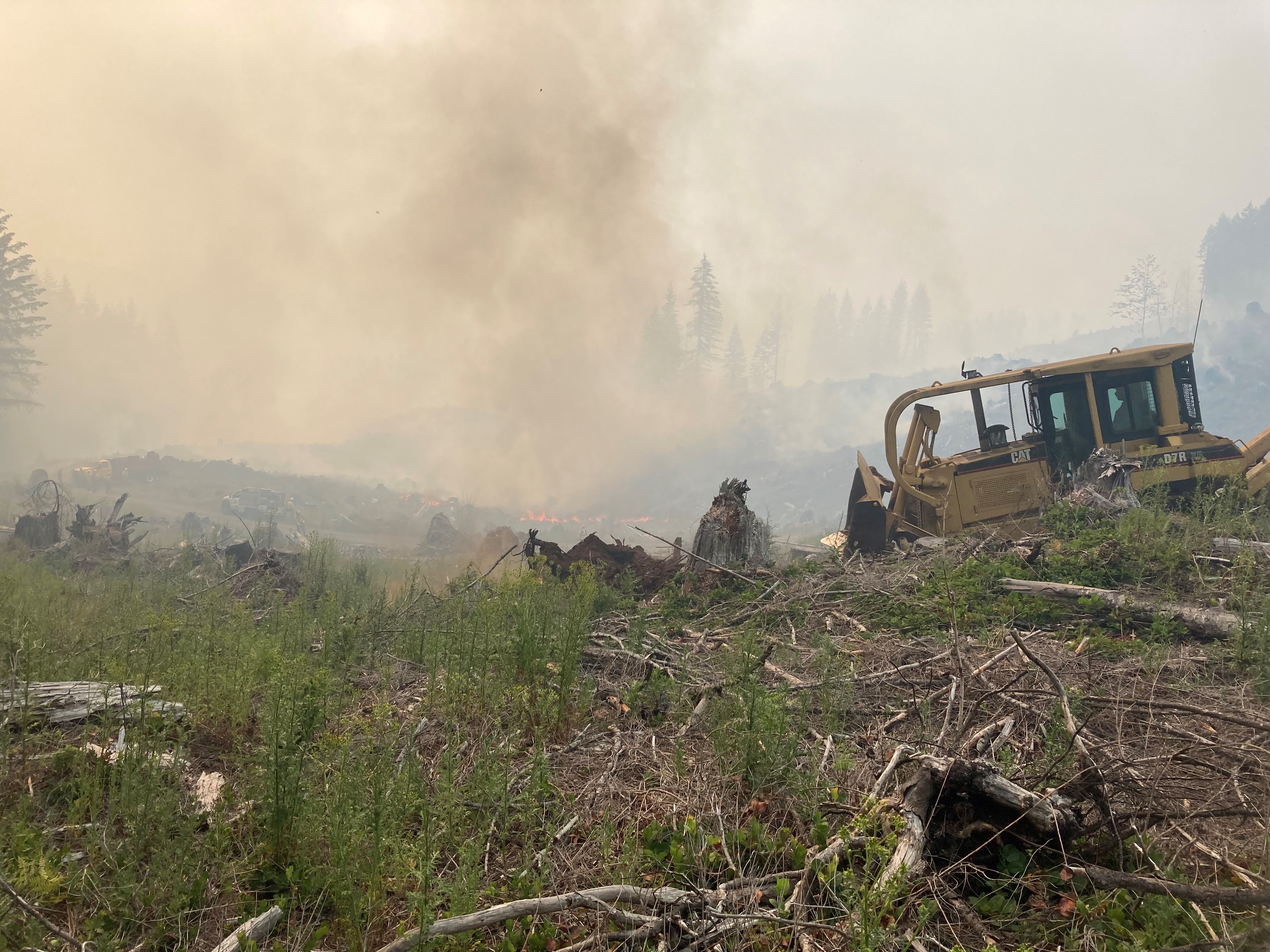
WILDFIRE UPDATES
Red Flag Warnings -Gusty afternoon winds occurred again through the valleys and basins east of the Cascades with slightly cooler temperatures across the geographic area. Clouds stayed west of the Cascades with smoky conditions over much of the east. Existing large fires again demonstrated active to extreme fire behavior as conditions remain dry. Initial attack was light in numbers, though the new fire, Elbow Creek Fire, grew to 5,000 acres in timber and grass in northeastern Oregon.
An upper level trough will remain in place across the Pacific Northwest through the end of the week. Gusty winds will persist through the Cascade gaps and across the east side basins into Friday evening along with low relative humidities east of the Cascades. Relatively cooler temperatures are also forecast Friday into Saturday which will produce slight increases in humidity levels east of the Cascades. No significant precipitation is expected into the weekend.
The overall flow is expected to turn more southerly early next week as an upper level ridge builds over the Great Basin and the Rockies. The southerly flow may draw some monsoonal moisture into the eastern tier of the region creating a threat of scattered thunderstorms early next week.
With fire danger above average in most areas, hot, dry and breezy conditions will maintain elevated potential for new
significant fire development east of the Cascades and in southwestern Oregon. Potential could moderate some toward the end of the week if cooler weather arrives as anticipated.
https://gacc.nifc.gov/nwcc/content/products/intelligence/MORNINGBRIEF.pdf?2015-06-23%2021:26:00
Bootleg Fire Remains Largest Fire in the Nation
Bootleg. OR-FWF-210321. Unified Command: IMT1, PNW Team 2 (Allen), IMT1, ODF Team 1 (Hessel) & OSFM Green
Team (Hallman). 15 mi NW of Beatty, OR. Start 7/6. Full Suppression. Cause: Unknown. 227,234 acres (+14,857). 7%
containment. Extreme fire behavior. Timber and brush. Structures threatened. Evacuations in effect. Road, trail and area closures. IMT2, NW Team 10 (Lawson) has been released.

The Bootleg fire currently 28 miles northeast of Klamath Falls has grown to 227,234 acres and is just 7% contained. There are currently 1,716 firefighters on scene battling the blaze. Firefighters reported another day of extreme fire behavior including torching, running, and frequent spotting ahead of the main fire including growth into the Gearhart
Wilderness and north towards Lake Henry. The Log Fire, located 8 miles southwest of Summer Lake, continued to spread to the east driven by steady west winds and is now 4,830 acres.
Large pyrocumulus clouds developed over the eastern portion of the fire during the afternoon and are possible again today. Throughout the night, crews continued working in the greater Fuego Mountain area as well as to the southeast along the 34 Road, improving existing containment lines.
Joe Hessel, Incident Commander for ODF Team 1 Incident Management Team said “This fire is going to continue to grow – the extremely dry vegetation and weather are not in our favor. “We are going to continue to prepare lines, protect structures, and move resources as we can around the fire’s edge.” With continued west winds predicted, firefighters will continue to work to hold the fire to the 34 Road to prevent further eastern and southern spread.
Heavy beetle killed timber and active fire behavior will present challenges in keeping the fire north and west of this road. Crews will continue to work on strengthening their existing line as well as scout for potential contingency lines. Structure protection groups are in place along the fire to help reduce risk to area homes.
Heavy smoke expected today with widespread impacts to communities and State Route 140 between Chiloquin and
Bly. A virtual community meeting is scheduled for tonight at 6:30pm at www.facebook.com/BootlegFireInfo. For those that have had to evacuate shelters are located at the Klamath County Fairgrounds, La Pine Middle School and at the Daly Middle School Auditorium.
Jet Fuel Shortage Impacting Firefighting Efforts
A national shortage of jet fuel impacted the Lake County Airport earlier this week as firefighting efforts on the Bootleg Fire ramped up along the county’s western reaches.
Airport officials across the U.S. West have sounded the alarm about the jet fuel shortage and the potential that they will have to wave off firefighting aircraft during an already active fire season. Some tanker bases have already encountered sporadic shortages, pointing to supply chains that atrophied during the pandemic.
According to the Lake County Sheriff’s Office, the airport ran out of Jet A fuel on Sunday, the day after the Bootleg Fire’s most alarming growth. The airport manager had placed an order for fuel nearly a week prior, but delivery was delayed.
The Lake County commissioners and emergency manager were made aware of the issue early Monday morning. They immediately took action looking for Jet A fuel in order to prevent an impact to wildfire initial attack and air ambulance operations at the Lake County Airport.
On Wednesday, Ocean Air in Klamath Falls delivered 3,500 gallons of Jet A fuel to Lake County, and officials said that the usual supplier Phillips 66 would bring 8,500 gallons more by today.
Jack Fire:
Jack Fire. OR-UPF-000265. IMT2, NW Team 9 (Goff). 20 mi E of Glide, OR. Start 7/5. Full Suppression. Cause:
Unknown. 15,248 acres (+1,453). 25% containment. Active fire behavior. Timber and brush. Structures threatened.
Evacuations in effect. Road, trail and area closures

Crews are working to reopen Oregon 138E affected by the Jack Fire, perhaps by this weekend. The road has been closed since the afternoon of July 5 between Steamboat and Slide Creek. The Jack Fire is now burning away from the North Umpqua Highway.
It caused minimal damage to the highway as compared to previous fires in the scenic corridor. Several hazard trees and other debris caused by the fire are still on or near the highway, but crews are working quickly to hit the weekend reopening goal. Crews are also evaluating burnt signs and sections of guardrail. They are making plans for their
replacement. When the highway does reopen, Griffin urged drivers to be careful, watch out for crews and expect delays due to slower speeds in the burn area. Motorists can also expect frequent delays throughout the summer between Idleyld and Steamboat and near Diamond Lake due to rehabilitation work on last year’s Archie Creek and
Thielsen wildfires
Grandview Fire:
Grandview 0558 OD. OR-955S-000558. IMT1, ODF Team 2 (Howard) & OSFM Red Team (Yocum). 10 mi NE of Sisters, OR. Start 7/11. Full Suppression. Cause: Unknown. 5,971 acres (+0). 20% containment. Minimal fire behavior. Timber and brush. Structures threatened. Evacuations in effect. Road and area closures.

Evacuation information: Sisters Middle School, located at 15200 OR-242 in Sisters has been set up as a temporary evacuation point. Level 1, 2 and 3 evacuation orders have been issued in Deschutes and Jefferson Counties.
Three homes, 11 structures and an RV were destroyed in the Darlene Fire, officials confirmed Wednesday, as crews battled two separate wildfires in Central Oregon.
The losses occurred Tuesday, said Stacy Lacey, a spokesperson with the U.S. Bureau of Land Management.
Firefighters were able to slow the Grandview Fire, 9 miles northeast of Sisters, and the Darlene Fire, 2 miles southeast of La Pine, on Wednesday. The Grandview Fire was 10% contained and has burned 5,971 acres, fire officials said during a community briefing Wednesday evening on Facebook.
Some 420 structures remain under threat near Sisters, according to McAdoo.Three crews arrived Tuesday night in Sisters from the state of Washington, joining seven other crews already working to protect homes near the Grandview Fire, according to a press release. With hot, windy conditions, structure protection and the safety of residents was the top priority for firefighters Wednesday.
The National Weather Service issued a red flag warning throughout Central Oregon due to anticipated gusty winds and low relative humidity beginning Wednesday afternoon and lasting through Thursday evening.
Winds did not exceed 10 mph Wednesday afternoon, but were expected to increase to as much as 10 mph out of the west later in the day, McAdoo said.
According to fire officials, 694 personnel, 49 hand crews, 15 fire engines, 15 dozers and two helicopters were sent to the Grandview Fire on Wednesday.
Multiple retardant-dropping air tankers were pulled away from the Grandview Fire in the afternoon to respond to the Darlene Fire, but three additional air tankers were ordered out of Burns for the Grandview Fire that later provided critical assistance, according to a Central Oregon Fire Info press release.
Level 3 “go now” and Level 2 “get ready” evacuation notices remain in place for residents northeast of Sisters, according to the Deschutes County Sheriff’s Office.
Sisters Middle School is set up as an evacuation center, and the Deschutes County fairgrounds is open for animal shelter. According to the Pet Evacuation Team, 10 horses, 30 goats, five or six dogs and some cats are currently being sheltered at the fairgrounds. Level 3 “go now” and Level 2 “get ready” evacuation notices also remain in place for residents southeast of La Pine.
La Pine Middle School is set up as an evacuation center, and the La Pine rodeo grounds for animals. Multiple horses were being transported to the rodeo grounds Wednesday afternoon, according to the Pet Evacuation Team.
Smoky conditions were visible Wednesday in Bend. Air quality was “moderate” throughout Central Oregon Wednesday afternoon, according to the Oregon Department of Environmental Air Quality.
Bruler Fire:
Bruler. OR-WIF-210239. IMT2, NW Team 13 (Gales). 10 mi S of Detroit, OR. Start 7/12. Full Suppression. Cause:
Unknown.156 acres (+1). 0% containment. Timber. Moderate fire behavior. Road, trail and area closures.

Firefighters took advantage of mild weather to make significant progress on the Bruler fire. A Type 2 helicopter continued dropping water to cool the interior while ground crews attacked the fire directly, digging handline for containment. Lines were further strengthened by two dozers, working to keep the fire within a small footprint. The fire is estimated to be 90 acres.
An additional 20 person hand crew and engines have arrived on the fire line. Northwest Incident Management Team 13, a Type 2 team, assumed command of the fire this morning. The fire is not currently threatening any communities or structures and there are no evacuation orders in place. The cause of the fire remains under investigation.
The weather will continue to be favorable including temperatures in the 70s and high relative humidity overnight. While the fire does still have potential to spread, fire behavior is expected to be moderate for the next few days allowing firefighters opportunities to make additional progress.
Air quality in and around the communities of Detroit and Sweet Home continues to be listed as “good”. Light winds from the north and west are keeping smoke from the Bruler Fire and surrounding larger fires to the south and east.
To provide for public and firefighter safety a large area closure is being finalized. This closure will encompass large portions of Forest Service lands south of Detroit Lake, west of Highway 22 and north of Highway 20. The closure will also include the Middle Santiam Wilderness, Daly Lake, Tule Lake and the trail network known as the Old Cascade Crest trail system. The closure will be posted to the Willamette National Forest webpage. Visitors are asked to avoid Bureau of Land Management (BLM) lands along the Quartzville Scenic Byway/Quartzville road including Yellowbottom Campground and Old Miner’s Meadow Group Site. Visit InciWeb (link below) for more information about closures in the area.
Darlene Fire:
Darlene 0572 NE. OR-PRD-000572. IMT2, NW Team 6 (Sheldon). 1 mi E of La Pine, OR. Start 7/13. Full Suppression.
Cause: Unknown. 678 acres (+90). 5% containment. Moderate fire behavior. Timber and brush. Structures threatened. Road closures.

Yesterday the northern half of the Darlene Fire area had spot fires that were caught and the eastern portion of the fire was plumbed with fire hose line. A spot fire went beyond the perimeter and was extinguished. Some of the western side of the fire was also plumbed.
Crews worked on the fire until midnight last night until no active movement was happening.There is a Red Flag Warning in effect through 11:00 p.m. tonight due to low humidity and high wind potential. Winds will be from the southwest switching to northwest in the afternoon with sustained speeds of 20-25 mph. Temperatures are predicted to be 83 to 86 degrees.
Today’s operations will include strengthening the containment lines along the fire perimeter and watching for any spot fires which could occur outside of the established lines. Dust continues to be an issue on unpaved roads. Exercising caution when driving and reducing speeds helps minimize the amount of dust that kicks up impeding visibility. Be aware of fire personnel on the roads and stay away from the Level 3 Evacuation area.
Evacuation status as of 8 a.m. July 15th: https://www.deschutes.org/sheriff/page/emergency-information Level 3: Go Now
Residences on Darlene Way south of La Pine to the Deschutes/Klamath County line, and along Old Ice Cave Road.Level 2: Be Set Areas south of the Deschutes/Klamath County line including the Sun Forest Estates, Split Rail subdivision and Antelope Meadows.
Log Fire:
Log. OR-FWF-210329. IMT1, PNW 2 (Allen). 25 mi S of Silver Lake, OR. Start 7/12. Full Suppression. Cause:
Unknown. 4,830 acres (+2,353). 0% containment. Active fire behavior. Timber and brush. Road and area closures.

Firefighters reported another day of extreme fire behavior including torching, running, and frequent spotting ahead of the main fire including growth into the Gearhart Wilderness and north towards Lake Henry. The Log Fire, located 8 miles southwest of Summer Lake, continued to spread to the east driven by steady west winds and is now 4,830 acres. Large pyrocumulus clouds developed over the eastern portion of the fire during the afternoon and are possible again today. Throughout the night, crews continued working in the greater Fuego Mountain area as well as to the southeast along the 34 Road, improving existing containment lines.
“This fire is going to continue to grow – the extremely dry vegetation and weather are not in our favor,” said Joe Hessel, Incident Commander for ODF Team 1 Incident Management Team. “We are going to continue to prepare lines, protect structures, and move resources as we can around the fire’s edge.”
With continued west winds predicted, firefighters will continue to work to hold the fire to the 34 Road to prevent further eastern and southern spread. Heavy beetle killed timber and active fire behavior will present challenges in keeping the fire north and west of this road. Crews will continue to work on strengthening their existing line as well as scout for potential contingency lines. Structure protection groups are in place along the fire to help reduce risk to area homes.
Community Meeting: Please join us for a virtual community meeting Friday July 16, 2021 at 6:30pm at www.facebook.com/BootlegFireInfo.
Evacuations: Evacuations are rapidly changing due to the nature of this wildfire. Please visit tinyurl.com/bootlegevac for an interactive map of evacuation level in Lake and Klamath Counties.
Greenridge Fire:
Green Ridge. OR-UMF-000659. IMT2, NW Team 7 (Loomis). Start 7/7. Full Suppression.
Cause: Lightning. 467 acres (+75). 15% containment. Moderate fire behavior. Grass and Timber. Structures threatened. Road, trail and area closures.

The Turkey Tail and Green Ridge fires began from lightning strikes July 7. The fires are managed as one incident, called the Green Ridge fire. The fires are in steep, remote and rugged terrain. Values at risk include Wilderness, residences and recreation facilities.
The fire grew 75 acres yesterday, primarily to the north. Firefighters scouted locations for indirect fire line to the east and cleared fuels along Kendall Skyline Road to the east and the 4608 Road to the south.
Facing extreme fire weather and very difficult and dangerous fire line construction, firefighters have modified their tactics while still implementing the strategy to minimize the size and duration, while prioritizing firefighter and public safety. Today, firefighters will work to improve indirect fire lines on roads to the east and south of the fire where terrain, fuels and weather have made direct fire line construction difficult. Scouting and line location continues to the east. Crews will continue improving structure protection around Godman Guard Station and the Little Turkey Tail Recreation Residents tract. Where terrain and fuels allow crews to safely engage, firefighters will directly limit the fire spread using helicopters and fixed-wing aircraft.
The Umatilla National Forest implemented an area and road closure across the entire Pomeroy Ranger District.
Game Hog Creek Fire:
Containment lines are holding on wildfire in the Tillamook State Forest
The firelines firefighters dug to control the Game Hog Creek Fire burning in the Tillamook State Forest have held. About 80 ground crew are engaged on the wildfire. They have been aided by helicopters assisting with air drops onto the fire, which is in a steep, inaccessible area of the forest.
More precise mapping shows the fire, which is about 22 miles northwest of Forest Grove, has burned a little over 130 acres.
Temperatures overnight are expected to drop somewhat, which will help retain moisture in the air. Cooler air off the ocean is expected to move inland over the fire on Friday, which should also aid firefighters.
Most of the Tillamook State Forest remains open to visitors with the exception of Drift Creek and Idiot Creek forest roads and the Fear and Loaming mountain bike trail due. These are closed due to fire activity in the area. Rogers Camp trailhead is being used as a staging area for firefighters and is also closed to the public. Highway 6 and 26 to the coast remain open and unaffected by the fire, which is entirely within the state forest.
Cause of the fire is still under investigation. Oregon Dept. of Forestry –
NEW FIRE– Elbow Creek Fire:
Elbow Creek. OR-UMF-000745. ICT4. Start 7/15. Full Suppression. Cause: Unknown. 5,000 acres. 0% containment. Extreme fire behavior. Timber. Area closures.

The Elbow Creek Fire burning in Northeast Oregon was first reported at 2:32 p.m. July 15, according to a press release from the U.S. Forest Service.
Just a few hours later, the Wallowa County Sheriff’s Office evacuated the Troy and Eden Bench areas.
Level 3 Evacuation orders are in place for Troy and residents living along Wild Cat Road, Powwatka Road, and the 500/501 up to the 763, according to the Wallowa County Sheriff’s Office Facebook page.
The fire is burning in Elbow Creek on the Walla Walla Ranger District of the U.S. Forest Service.
At 6 p.m. Thursday, officials said firefighters were actively suppressing the “rapidly growing wildfire” wildfire located near Mud Springs, approximately five miles northwest of Promise, Oregon.
It’s estimated to be 700 to 1000 acres in size. The cause of the fire is under investigation.
The Wallowa County Sheriff’s Office has issued a Level 3 evacuation notice for community members that live in the Eden Bench area. A Level 3 means those within the evacuation area should leave immediately.
Additional information regarding evacuations is available through the Wallowa County Sheriff’s Office at (541) 426-3131 or by monitoring the Wallowa County Sheriff’s Office Facebook.
Numerous resources are aiding in initial attack efforts, including support from Oregon Department of Forestry. Firefighter suppression efforts are also being supported by various aerial resources, including two helicopters and fixed wing retardant. Additional resources are on order.
Hot and dry conditions are expected to persist throughout the week. Fire officials want to remind everyone that the current fire danger rating remains at EXTREME and public use restrictions involving chainsaw use, smoking and off-road travel are in effect.
Film Highlights Oregon’s Wild and Scenic River System

River Democracy Act, filmed by Shane Anderson and produced by Pacific Rivers, highlights Senator Ron Wyden’s efforts to preserve the state’s rivers.
In October 2019, Wyden set out to substantially increase the number and miles of the state’s watersheds protected as Wild and Scenic Rivers. After evaluating the recommendations of their fellow Oregonians, Wyden and his staff settled on 800 separate sections, comprising a total of nearly 4700 miles, of Oregon rivers to include in the River Democracy Act.
A Wild and Scenic is sort of like the national park system for rivers. It protects the free-flowing nature of rivers and safeguards them against damming and harmful development, while still leaving room for river management that is in line with river conservation. A Wild and Scenic designation also protects 1/4-mile of land on each side of a designated river, making this a powerful tool for protecting the full suite of resources — habitat, water, food — that are so important for wildlife and overall watershed health.
The River Democracy Act would protect over 4,600 miles of rivers and streams in Oregon but Sen. Wyden is protecting far more than miles of rivers or acres of high-value riverside land. His sweeping act defined by an unprecedented public process would protect Oregon’s most valuable natural resource, which provides clean drinking water, fish and wildlife habitat and supports Oregon’s outdoor recreation economy.
According to Earth Economics, that economy supports 224,000 jobs statewide and generates $15.6 billion in consumer spending. The legislation supports good hunting, fishing and other outdoor recreation, and supports small businesses as more and more Oregonians find refuge in the outdoors.
Wyden said: “Rivers and streams are Oregon’s lifeblood, providing clean drinking water for our families, sustaining our thriving outdoor recreation economy, and nurturing the quality of life that brings new investments, businesses and jobs to our state.” And it’s true — not just for Oregon, but also for rivers and their tiny counterparts across the nation.
The River Democracy Act does something else that’s important, and timely. It recognizes the importance of protecting sources for drinking water — it sees the forest and the threats posed to the forest by climate change. The bill establishes a new national source for funding to restore rivers that have been devastated by fire and that provide drinking water, such as those that burned in Oregon in 2020.
And yet, even if the River Democracy Act becomes law, the nearly 7,500 miles of rivers and streams protected in Oregon will still represent a miniscule fraction of Oregon’s 110,994 total miles of rivers. Just 0.004 percent of the 3.5 million miles of streams and rivers in this country are protected as Wild and Scenic. Sure, a Wild and Scenic designation isn’t the only way to protect these rivers. But it is a powerful and arguably underutilized tool.
And right now, river protectors have momentum on our side. Biden’s pledge to advance the protection of at least 30 percent of the nation’s lands and waters by 2030 comes out of a growing recognition of the immense value these resources provide, and the myriad ways they are threatened. Wild and Scenic protections like the River Democracy Act move this vision forward.